


This is the Current Release Version of the ChartAware application for use by SCAUWG.ORG visitors.
EXCITING! - DISCOVER the AIRSPACE NO ONE TOLD YOU ABOUT!
NOW: DOWNLOAD the Program for Use with Your iPAD
ForeFlight Compatible!!
Garmin Pilot Compatible!!
![]()
Do you know where the boundaries are for flight training and aerobatic areas in the Southern California area? Take a look at our Interactive Practice Area Map Application. This interactive map, provided by SCAUWG, will show you the approximate locations of "Practice Areas", along with important information such as the ceiling altitudes, air-to-air frequencies, and other caution information. You can even turn on different aeronautical charts for backgrounds and typical air traffic tracks. Be a safer pilot and check it out! Just CLICK ON the IMAGE Below.
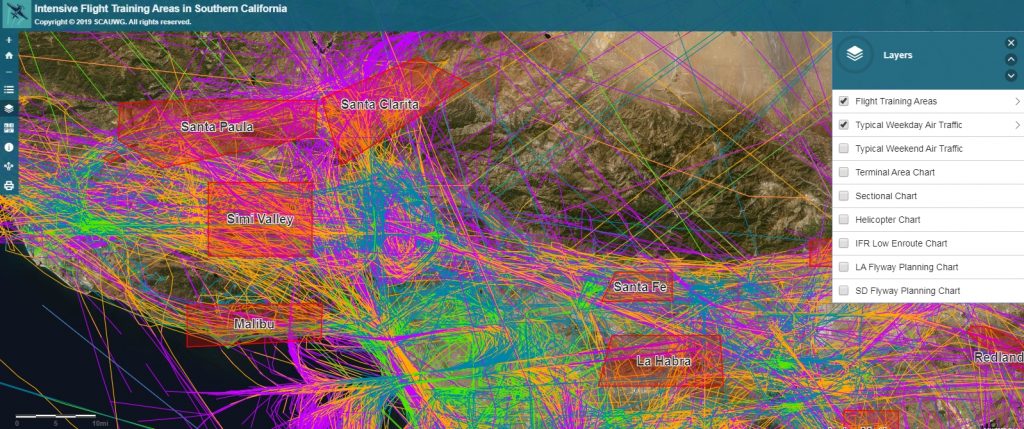
This first release version has further content changes/enhancements beyond those found in the beta version and is a powerfully loaded application that allows users to access a tremendous amount of information and to overlay flight tracks on not only FAA Published Navigation charts, but also a host of other charts/maps e.g. a street map, topography map, etc. The current version, 2.0 is downloadable and is designed to be used as an overlay with popular flight navigation applications like ForeFlight and Garman pilot. Your Comments Are Invited! Just send your input via the Contact SCAUWG option. ChartAware has been developed via the vision of Cartographer Mike Carson and Ron Berinstein CFII, webmaster/director, SCAUWG.ORG. The flight track information was gathered by Mike Carson and represents actual data over typical 24-hour periods, weekday and weekend. The displayed routes are color coded in order to display altitude information.
- Use With ForeFlight, or any program that accepts KML files!
Download the Aerobatic/Practice Areas
Want to add the aerobatic and practice areas to ForeFlight? Just download this KML file and add it as a custom map layer under Custom Content in ForeFlight. Need help doing that? Just follow the Import Custom Content directions from ForeFlight. The email option is the easiest.
To turn on the KML layer in ForeFlight, go to Maps, click on Aero & Category at the top, scroll down the second column of data layers, and at the bottom you will see the KML layer. Just click on it to turn it on! Zoom in and click on one of the center points in a practice area, an info window will open to the right where you can click on More Details to see more info about the practice area. Info includes the name, ceiling, frequency to use, and any caution info.
- For Use with the Android app. iFlyEFB - View installation directions by Clicking/Tapping Here.