


This is the Current Release Version of the AirportAware application
for use by SCAUWG.ORG visitors
![]()
EXCITING! - DISCOVER the possible NATURAL HAZARDS
NO ONE TOLD YOU ABOUT!
Access this Program for Use with Your Phone, Laptop or Desktop
Just CLICK ON THE IMAGE to get the free App.
Should a SIGN-IN box result - Click "CANCEL" twice.
AirportAware - created by MIKE CARSON
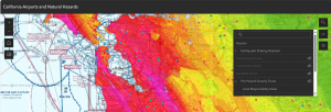 Interactive Chart for with TAC and Sectional Overlays that displays the possible dangers you select.
DIRECTIONS:
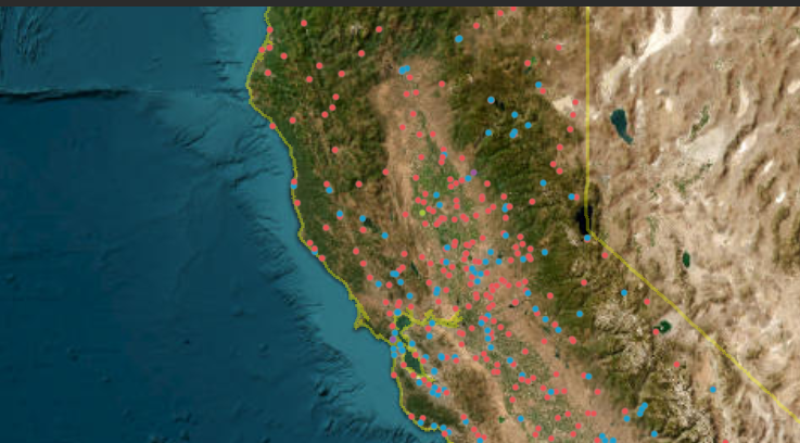 When the app opens you will see a satellite image and dots on the map of California airports. On the right the layer list is open and you can turn on/off layers by clicking the eyeball next to each. Some layers are grayed out which means you must zoom in to be able to see them on the map. I have included airport points, earthquake shaking potential, flood hazard zones, liquefaction zones, landslide zones, tsunami hazard areas, sectional chart, and the California boundary.You can click on most features to get attribute information. If you click on an airport point, you will see more attribute information as well as a link that takes you to airnav.com for more info. Airport identifiers appear as you zoom in closer on the map.Also, on the right there is a search icon to zoom to an address as well as a legend icon. On the left if you click the home icon the map zooms out where it started. There are zoom in and zoom out icons as well as a screenshot icon.
Try the app out! The app also works on mobile devices but might look a bit different because of the screen size.
SCAUWG,ORG wishes to acknowledge with thanks the CalDart organization for the inspiration to create this application. AirportAware is created by professional cartographer, SCAUWG technical advisor, and SCAUWG.ORG Contributing Editor, Mike Carson. This version is number one (V.1.0).