


“Supporting Airports, Strengthening Communities”
Updates & Proposed Changes
CLASS C CONFLICT with CHINO Traffic Pattern
The Los Angeles Terminal Area Chart (TAC) is updated every 56 days.
How to REPORT CHART ISSUES: "Aeronautical Inquiries"
Use this link: http://www.faa.gov/air_traffic/flight_info/aeronav/aero_data/aeronautical_inquiries
VFR CHART CHANGE NOTICES:
The Western Service Center Operations Support Group provided the attached “CHARTING NOTICE – 56-Day Visual Charts” from the FAA web site; https://www.faa.gov/air_traffic/flight_info/aeronav/safety_alerts/
The notice states; "Like other FAA Supplement, Enroute and Terminal products, each new visual navigation chart title panel will indicate the applicable AIRAC effective date range and no longer include an edition number.”
As the IFR charts on 56-day publishing schedule do not have an edition number, the new 56-day visual charts will be identified in the same way using effective dates.
Aeronautical Charting Meeting (Charting Group)
- The Aeronautical Charting Meeting (ACM) is a public meeting held two times every year. The purpose of the ACM is three-fold:
- Identify issues concerning safety and usefulness of aeronautical charts and flight information products/services.
- Discuss and evaluate proposals concerning aeronautical charts and flight information publications, digital aeronautical products, database coding, instrument flight procedures, and instrument flight procedure development, policy, and design.
- Provide an opportunity for government and interested participants to brief and/or discuss new navigation concepts, terminal instrument procedures (TERPS) policy/criteria changes, and charting specifications and methodologies.
The Aeronautical Charting Meeting is divided into two groups — the Instrument Procedures Group (IPG) and the Charting Group (CG) See Order 7910.5.
The CG portion of the ACM includes briefings and discussions on recommendations regarding aeronautical charts and flight information products/services. Please visit the ACM Instrument Procedures Group Web Site for information regarding Instrument Procedure issues.
The meeting is a facilitated discussion of new and outstanding topics. The status of an open issue will be reported from meeting to meeting until a resolution is reached, at which point the issue will be closed.
Aeronautical Charting Meeting (ACM) — Charting Group
Next Meeting
5/16/25: "We are planning to hold ACM 25-02 October 6-9, 2025. The new Recommendation Document submission deadline for ACM 25-02 is September 5, 2025."
- To be added to the ACM email distribution list, send a message with your first and last name and email address to: 9-amc-avs-acm-info@faa.gov
-
FOR: ACM Instrument Procedures Group and Charting Group Attendees,
As a result of the cancelation of ACM 25-01, the new Recommendation Documents (RDs) that were submitted for the April meeting will be added to the agenda for discussion at the 25-02 meeting, planned for October. The 25-01 RDs have now been posted to the IPG and CG websites. Due to other responsibilities, Gary Petty will be handing off the facilitation role for the IPG to Rune Duke, who will serve moving forward as the IPG Chair.
-
Jennifer Hendi, Chair ACM Charting Group - Rune Duke, Chair ACM Instrument Procedures Group - Jennifer L. Hendi
-
Aeronautical Information Services - Charting Products Integration Team, AJV-A25 - Visit Aeronautical Information Services Here
Rune Duke - Aviation Safety - Flight Technologies & Procedure Division, Flight Procedures & Airspace Group - Division Feedback: 9-AWA-AVS-AFS-400-flight-technologies-procedures@faa.gov
Flight Technologies & Procedures Division webpage
New Recommendation Documents for Upcoming ACM (CG)
New submission deadline for ACM 25-02: Close of business September 5, 2025.
Submitted new Recommendation Documents:
- C_25-01-396 Charting of Radial Distances for Class C Airspace (PDF)
- C_25-01-397 Mountain Pass Routes (PDF)
- C_25-01-398 Charting of Non Standard CPDLC Logon Information (PDF)
- C_25-01-399 Charting of Communications on SIDs and STARs (PDF)
- C_25-01-400 Publish ATCAA boundaries (PDF)
- C_25-01-401 Quality Alert Metrics (PDF)
- C_25-01-402 Airport Remarks Format (PDF)
- C_25-01-403 Julian Dates in the Chart Supplement (PDF)
- C_25-01-404 Unused Marker Beacons in NASR (PDF)
- C_25-01-405 Runway End Safety Areas (PDF)``
FLIGHT in the INLAND EMPIRE - PRECAUTION!
Pilots should be aware that this is a busy flight area. Besides the VFR traffic (often with some legacy aircraft), and IFR traffic there is a multitude of IFR training flights flown in the area located around the Paradise VORTAC (PDZ). Extreme caution should be exercised. Be on the ook out for jet arrivals into SBD,
AIRSPACE NEWS & PROPOSALS & CHART NEWS
10/03/2025 Hello ACM Participants,
Due to the lapse in government funding, we are expecting to cancel the ACM that is scheduled to be held next week, October 6-9. If funding is restored by Sunday, October 5, we plan to move forward with the meeting as scheduled. If funding is not restored, you will receive an email Monday morning officially canceling the meeting. If that happens, we are looking at rescheduling for later this year. - In the case of cancelation, the new Recommendation Documents (RDs) that were submitted for the October meeting will be added to the agenda for discussion at the next meeting. These RDs have been added to the applicable website:
Thank you for your understanding. - Jennifer Hendi, Chair ACM Charting Group - Rune Duke, Chair ACM Instrument Procedures Group
Jennifer L. Hendi - Aeronautical Information Services - Charting Products Integration Team, AJV-A25 - Visit Aeronautical Information Services Here
Rune Duke - Aviation Safety - Flight Technologies & Procedure Division, Flight Procedures & Airspace Group - Flight Technologies & Procedures Division webpage
09/22/2025 New APIS Rules for Bizav Start in Mexico - From AIN - "The new process involves a two-step authorization - Revised advanced passenger information system (APIS) requirements for travel in Mexico were instituted this week. AIN confirmed that a new two-step submission process now applies to all private and charter flights into and out of the country. - According to business aviation flight data provider OpsGroup and Miami-based international ground handler CST Flight Services, the first APIS submission must be filed within two hours before departure, for both inbound and outbound flights. The second filing must be confirmation of the passengers on board, “sent after doors close and before takeoff.” Read More Here.
09/22/2025 Next Charting Meeting
- ACM 25-02 Agenda
Aeronautical Charting Meeting – (Charting Group)
07/15/2025 SCAUWG.ORG CONTRIBUTING EDITOR MIKE CARSON Makes a VFR Chart Change! EMAIL RECEIVED:
From: noreply@faa.gov
Date: July 7, 2025 at 10:29:45 AM PDT
To: mike@kb6fcc.us
Subject: Aeronautical Inquiry AI-247366 has been closed
Michael Carson,
Your Aeronautical Inquiry has been closed. If you have follow-up questions or comments, please use the online inquiry form instead of sending via email.
========================================================
FAA Response:Thank you for bringing this to our attention. The current depiction is shown in blue, but you are correct, the linework for the NOAA Regulated National Marine Sanctuary Designated Areas should be shown in magenta. We will address this discrepancy and anticipate implementing this update for a future cycle.
========================================================
AI-247366
Category: Charts & Publications > VFR Charts
Chart Type: VFR Charts
Chart: Los Angeles
Inquiry: On the Los Angeles sectional chart (June 2025) the Special Conservation Areas magenta symbol is missing. For example, it is missing around the Channel Islands.
========================================================You may view your Aeronautical Inquiries online at https://nfdc.faa.gov
Aeronautical Information Portal
https://nfdc.faa.gov
07/06/2025 The FAA is alleviating the requirement for operators to seek additional FAA approval prior to using Foreign Terminal Instrument Procedures or foreign CAT II/III Facilities.
This change:
- No longer requires operators to seek approval from Safety Assurance offices for individual foreign CAT II/III runway operations or individual foreign RNP AR procedures; however, C060 and C384 will still be required to fly these procedure types, whether foreign or domestic.
- Was initiated because these procedures and facilities have reached a level of maturity that additional individual FAA review is no longer required. This change will be disseminated via the following directives issuance/revision/cancelation.
Documents include:
- Issuing FAA Notice 8900.740 to ensure the:
- Removal of Foreign Tables from OpSpec/MSpec/LOA −
- C059, Special Authorization Category I (SA CAT I) Instrument Approach and Landing Operations
- C060, Category II and Category III Instrument Approach and Landing Operations
- C384, Required Navigation Performance (RNP) Procedures with Authorization Required (AR)
- Decommissioning of OpSpec/MSpec/LOA −
- C058, Special Restrictions for Foreign Terminal Instrument Procedures
- C358, Special Restrictions for “RNP-like” Foreign RNAV Terminal Instrument Procedures with RNP Lines of Minima
- H107, Special Restrictions for Foreign Terminal Instrument Procedures
- Removal of Foreign Tables from OpSpec/MSpec/LOA −
- Revising 8900.1, Volume 3, Chapter 18, Section 5, Part C Operations Specifications—Airplane Terminal Instrument Procedures and Airport Authorizations and Limitations
- Revising Advisory Circular 120-105B, Foreign Terminal Instrument Procedures (FTIP) Acceptance/Review (Cancelling previous version: AC 120-105A)
- Cancelling FAA Order 8260.31C, Foreign Terminal Instrument Procedures (FTIP)
Please go to the following link for further explanation of these changes and to Foreign RNP AR and Foreign CAT II/III facilities spreadsheets: Foreign Terminal IFP Approvals
Note: The Foreign RNP AR and Foreign CAT II/III facilities spreadsheets are updated and will continue to be posted for 90 days to assist operators with making this transition.
Please direct any questions you have to 9-AMC-FSIFP-Oversight@faa.gov.
07/06/2025 Requirements to Fly a CAT II approach:
§ 61.67 Category II pilot authorization requirements.
(a) General. A person who applies for a Category II pilot authorization must hold:
(1) At least a private or commercial pilot certificate with an instrument rating or an airline transport pilot certificate;
(2) A type rating for the aircraft for which the authorization is sought if that aircraft requires a type rating; and
(3) A category and class rating for the aircraft for which the authorization is sought.
(b) Experience requirements. An applicant for a Category II pilot authorization must have at least—
(1) 50 hours of night flight time as pilot in command.
(2) 75 hours of instrument time under actual or simulated instrument conditions that may include not more than—
(i) A combination of 25 hours of simulated instrument flight time in a flight simulator or flight training device; or
(ii) 40 hours of simulated instrument flight time if accomplished in an approved course conducted by an appropriately rated training center certificated under part 142 of this chapter.
(3) 250 hours of cross-country time as pilot in command.
(c) Practical test requirements.
(1) A practical test must be passed by a person who applies for—
(i) Issuance or renewal of a Category II pilot authorization; and
(ii) The addition of another type aircraft to the applicant's Category II pilot authorization.
(2) To be eligible for the practical test for an authorization under this section, an applicant must—
(i) Meet the requirements of paragraphs (a) and (b) of this section; and
(ii) If the applicant has not passed a practical test for this authorization during the 12 calendar months preceding the month of the test, then that person must—
(A) Meet the requirements of § 61.57(c); and
(B) Have performed at least six ILS approaches during the 6 calendar months preceding the month of the test, of which at least three of the approaches must have been conducted without the use of an approach coupler.
(3) The approaches specified in paragraph (c)(2)(ii)(B) of this section—
(i) Must be conducted under actual or simulated instrument flight conditions;
(ii) Must be conducted to the decision height for the ILS approach in the type aircraft in which the practical test is to be conducted;
(iii) Need not be conducted to the decision height authorized for Category II operations;
(iv) Must be conducted to the decision height authorized for Category II operations only if conducted in a flight simulator or flight training device; and
(v) Must be accomplished in an aircraft of the same category and class, and type, as applicable, as the aircraft in which the practical test is to be conducted or in a flight simulator that—
(A) Represents an aircraft of the same category and class, and type, as applicable, as the aircraft in which the authorization is sought; and
(B) Is used in accordance with an approved course conducted by a training center certificated under part 142 of this chapter.
(4) The flight time acquired in meeting the requirements of paragraph (c)(2)(ii)(B) of this section may be used to meet the requirements of paragraph (c)(2)(ii)(A) of this section.
(d) Practical test procedures. The practical test consists of an oral increment and a flight increment.
(1) Oral increment. In the oral increment of the practical test an applicant must demonstrate knowledge of the following:
(i) Required landing distance;
(ii) Recognition of the decision height;
(iii) Missed approach procedures and techniques using computed or fixed attitude guidance displays;
(iv) Use and limitations of RVR;
(v) Use of visual clues, their availability or limitations, and altitude at which they are normally discernible at reduced RVR readings;
(vi) Procedures and techniques related to transition from nonvisual to visual flight during a final approach under reduced RVR;
(vii) Effects of vertical and horizontal windshear;
(viii) Characteristics and limitations of the ILS and runway lighting system;
(ix) Characteristics and limitations of the flight director system, auto approach coupler (including split axis type if equipped), auto throttle system (if equipped), and other required Category II equipment;
(x) Assigned duties of the second in command during Category II approaches, unless the aircraft for which authorization is sought does not require a second in command; and
(xi) Instrument and equipment failure warning systems.
(2) Flight increment. The following requirements apply to the flight increment of the practical test:
(i) The flight increment must be conducted in an aircraft of the same category, class, and type, as applicable, as the aircraft in which the authorization is sought or in a flight simulator that—
(A) Represents an aircraft of the same category and class, and type, as applicable, as the aircraft in which the authorization is sought; and
(B) Is used in accordance with an approved course conducted by a training center certificated under part 142 of this chapter.
(ii) The flight increment must consist of at least two ILS approaches to 100 feet AGL including at least one landing and one missed approach.
(iii) All approaches performed during the flight increment must be made with the use of an approved flight control guidance system, except if an approved auto approach coupler is installed, at least one approach must be hand flown using flight director commands.
(iv) If a multiengine airplane with the performance capability to execute a missed approach with one engine inoperative is used for the practical test, the flight increment must include the performance of one missed approach with an engine, which shall be the most critical engine, if applicable, set at idle or zero thrust before reaching the middle marker.
(v) If a multiengine flight simulator or multiengine flight training device is used for the practical test, the applicant must execute a missed approach with the most critical engine, if applicable, failed.
(vi) For an authorization for an aircraft that requires a type rating, the practical test must be performed in coordination with a second in command who holds a type rating in the aircraft in which the authorization is sought.
(vii) Oral questioning may be conducted at any time during a practical test.
[Docket 25910, 62 FR 16298, Apr. 4, 1997; Amdt. 61-103, 62 FR 40900, July 30, 1997, as amended by FAA-2023-1275; Amdt. 61-157, 89 FR 92483, Nov. 21, 2024]
07/05/2025 CHARTING NOTICE - July 3, 2025
Users of: U.S. Terminal Procedures Publications
Digital-Terminal Procedures Publications
Chart Supplement Pacific - Aeronautical Information Services (AJV-A)
Removal of Redundant Communications Data from Instrument Approach
Procedure (IAP) charts.:
At the October 2024 Aeronautical Charting Meeting (ACM), a recommendation was submitted to remove
certain frequency data included in the bottom briefing strip of IAP charts because it is redundant and
contributes to chart clutter, potentially reducing clarity during critical phases of flight. This
recommendation subsequently received concurrence from stakeholders at the ACM.
Beginning with the October 2, 2025 publication date, FAA Aeronautical Information Services (AJV-A)
will begin removing redundant communications data from Instrument Approach Procedure (IAP) charts.
Departure ATIS, CLNC DEL, and the availability of CPDLC will not be charted when the information is
shown on the corresponding airport diagram.
View Aeronautical Information Services Safety Alerts and Charting Notices at
(https://www.faa.gov/air_traffic/flight_info/aeronav/safety_alerts/)
for awareness of chart and data corrections. A page subscription service is available.
07/01/2025
| Subject: | Aeronautical Inquiry AI-247366 Received |
|---|---|
| Date: | Tue, 1 Jul 2025 23:33:13 -0500 (CDT) |
| From: | noreply@faa.gov |
| To: | mike@ email |
Michael Carson, SCAUWG.ORG Contributing Editor
Your Aeronautical Inquiry has been received by the FAA.
========================================================
AI-247366
Category: Charts & Publications > VFR Charts
Chart Type: VFR Charts
Chart: Los Angeles
Inquiry: On the Los Angeles sectional chart (June 2025) the Special Conservation Areas magenta symbol is missing. For example, it is missing around the Channel Islands.
========================================================
You will receive email updates as your inquiry is processed. You may view your Aeronautical Inquiries online at https://nfdc.faa.gov.
Aeronautical Information Portal
https://nfdc.faa.gov
06/17/2025 LA TAC CHART - NEW ITEMS / CORRECTIONS:


Illustration Credit: Candy Robinson - Long Beach Flying Club


6/16/2025 TCAS RAs - WHERE in the LA AREA MIGHT YOU be CONCERNED? By report, one airline found that in one year their pilots experienced 9 in the Burbank area, 12 in the LAX area, Ontario yielded 15, and Santa Ana 6. Independent reports that the area northwest of Long Beach airport exactly where the LA TAC "FLYWAY PLANNING CHART " shows GA aviators should be. Unfortunately, that chart was created in the early eighties and has only been very minimally updated since. Today's reality is different. In the case of LGB, the Flyway Chart doesn't take into account jet departures from the airport that very well present a conflict. GA pilots might well consider planning flights with the aid of ChartAware, that when the website version is accessed, depicts recorded typical flight tracks over the LA Basin and indicates the altitudes flown. ChartAware is a free Flight Planning App featured on SCAUWG.ORG. You can check it out Here.
06/16/2025 HELICOPRTER Routes LAX AREA - CHANGES! LAX ISSUED LTA: Due to the unusual accident activity in the Washington DC area there have been inspired changes to the LA area. The following LTA has been issued. You can download a copy Here.

Close Up View Here (unavailable after August 7, 2025)

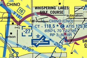
06/15/2025 Ontario Class C Airspace is expected to change in order to accommodate better the north pattern at Chino. Though there is a LOA with Chino when the aircraft is in contact with Chino Tower, there has been a source of discomfort and some unpredictable flight tracks that result when the pilot realizes that Ontario's Class C airspace is directly ahead. It should be noted that when the tower is closed the pattern is charted for south of the airport. When pilots use the north side ignoring the TAC Chart data, there is no LOA in effect. The proposed change to the Ontario Class C would help to alleviate the current problems caused by the "carve out." See the illustration below. It is anticipated that there will be a community forum in early August '25 to discuss the matter.

05/24/2025 InFO 24002, Alaska Guide Pilots has been revised. - This InFO provides information to operators and pilots engaged in Alaska Guide Pilot operations by discussing the statutory authorization provided in Section 732 of Public Law 106-181 for operations conducted under Title 14 of the Code of Federal Regulations (14 CFR) Part 91 and the limitations of that authorization. This InFO provides information on how to comply with regulatory requirements and on compliance with certain regulations that apply to operations for compensation or hire. - The InFO can be viewed by downloading the attached .pdf files or by clicking on the following link,
https://www.faa.gov/other_visit/aviation_industry/airline_operators/airline_safety/info/all_infos/
05/24/2025 This information has recently been updated, and is now available. - 28 Day NASR Subscriber Files - Eff. June 12, 2025dfs
Safety Alerts, Charting Notices & Data Product Notices
05/24/2025 This information has recently been updated, and is now available. - digital-Terminal Procedures Publications, Digital-Terminal Procedures Publications and Chart Supplement Pacific - Eff. Aug 7, 2025
Safety Alerts, Charting Notices & Data Product Notices
05/24/2025 PR Release: Washington, DC, May 14, 2025 – While the National Airspace System (NAS) remains the world’s safest, recent equipment outages across one of the nation’s busiest sectors have rattled pilots and air traffic controllers (ATC) alike. As the Federal Aviation Administration (FAA) works to resolve these challenges across the Northeastern U.S., the National Business Aviation Association (NBAA) urges business aviation flight crews to approach the situation with level heads and work strategically within established procedures.
On May 12, Transportation Sec. Sean Duffy announced the formation of a “tiger team” task force dedicated to resolving issues in the Philadelphia Terminal Radar Approach Control (TRACON Area C) sector that controls airspace overlying multiple New York City-area airports.
Solutions in the works include adding three new, high-bandwidth feeds between the New York-based Standard Terminal Automation Replacement System (STARS) and the Philadelphia TRACON to provide greater speed, reliability and redundancy. The FAA is also deploying a temporary backup system to maintain communications, with plans for a dedicated STARS hub for the Philadelphia location.
Additional controllers are also part of the solution. The FAA noted Area C currently has 27 fully certified controllers and supervisors on duty, with an additional 21 in training. Of the latter, 10 are receiving on-the-job training to cover additional sectors but are already certified on at least one position, with three certified on multiple positions.
In the near term, however, flight crews should expect possible traffic management initiatives in the region, which may impact operations to and from some of the area’s busiest general aviation airports including New Jersey’s Essex County Airport (CDW), Morristown (MMU) and Teterboro (TEB).
“NBAA is in direct dialogue with the FAA to work through this situation,” said Heidi Williams, NBAA senior director of air traffic services and infrastructure. “We encourage business aviation flight crews to consider their alternatives before wheels up. Think strategically, as always, but remain flexible in your plans.”
For example, congestion at TEB may drive crews to file Westchester County Airport (HPN) as an alternate, leading to similar delays at that New York airport. “Consider and plan for additional alternatives outside the immediate area or drop and go operations could be an option,” Williams said. “Pilots may also consider tankering additional fuel in the event of delays or reroutes.” - NBAA also urges pilots to utilize flight planning resources available from both NBAA and the agency. That includes subscribing to Airspace/Airport Alerts from NBAA Air Traffic Services, and staying updated on the status of the National Airspace System through nasstatus.faa.gov.
Additionally, NBAA will host a live News Hour webinar featuring expert guidance on the procedures and tools in place to manage operations in the near term and how to ensure business aviation flights in the sector support the highest levels of safety. - Williams stressed crews should not attempt to deviate from established airspace procedures. “We recognize the challenges and strongly encourage crews to keep level heads, exercise patience and thorough preflight planning, and we’ll get through this together.”
05/11/2025 MINI ROUTE may not be Available due to understaffing at LAX Tower. It will remain on the TAC Chatr.
05/11/2025 Aeronautical Data Delivery Service (ADDS) - Eff. Apr 17, 2025 - See the changes (including the new location of the climb/decent table data) Click or Tap: Safety Alerts, Charting Notices & Data Product Notices
05/09/2025 General and Business Aviation Call to Action: Airport Familiarization - Notice Number: NOTC4406
- Reminder: Familiarization with your Destination Airport is Important
The FAA and the aviation community are committed to pursuing a goal of zero serious close calls and improving situational awareness in the airport surface environment. Be sure to utilize all the tools available and get acquainted with your destination airport before you takeoff.
- Arrival Alert Notices
To manage wrong surface events where an aircraft lines up to or lands on the incorrect runway, taxiway, or airport, the FAA released Arrival Alert Notices (AAN) at airports with a history of misalignment risk. AANs are graphics visually depicting the approach to a particular airport and language describing the risk of misalignment. You can view the complete list of AANs at www.faa.gov/aan.
- From the Flight Deck
The FAA’s From the Flight Deck video series (https://bit.ly/2Mj0Cme) provides pilots with actual runway approach and airport taxiway footage captured with aircraft-mounted cameras, combined with diagrams and visual graphics to clearly identify hot spots and other safety-sensitive items. The videos also provide advice for pilots on how to mitigate the risk of runway incursions and wrong surface events.
To supplement the videos, the FAA also publishes additional “Pilot Handbook” content. This includes details such as airport-specific cautions, information local controllers want pilots to know, airport communications, airspace details, and other preflight planning resources. To learn more visit www.faa.gov/flight_deck.
- Aeronautical Charts
Aeronautical charts are the road map for a pilot flying under VFR. The charts provide information that allows pilots to track their position and provides available information that enhances safety. Always review your destination’s Chart Supplement to become aware of any special aviation activities, traffic patterns, or obstructions. Prepare for your next flight by checking the charts at www.faa.gov/air_traffic/flight_info/aeronav/digital_products/.
In early March 2025, the FAA held an Aviation Safety Call to Action (www.faa.gov/newsroom/faa-takes-immediate-safety-steps-following-general-and-business-aviation-call-action) to identify concrete steps to address recent safety incidents and make general and business aviation safer. As part of our commitment to aviation safety, we are reminding general and business aviation pilots about the tools and resources available to them during their pre-flight, in-flight, and post-flight activities. Learn more about the GA Call to Action at www.faa.gov/GA-action.
Special Programs Section (AFS-830) SafetyBriefing@faa.gov - (202) 267-1100
05/04/2025 NTSB probing aborted landings at Reagan National Airport prompted by nearby Army helicopter - From CNN - "The National Transportation Safety Board is investigating the aborted landings of two commercial flights approaching Reagan National Airport on Thursday as a US Army Black Hawk helicopter was approaching the Pentagon nearby. - Helicopters near the airport have been under intense scrutiny since the January 29 midair collision of American Airlines Flight 5342 and an Army helicopter from the same unit. The crash killed 67 people.
The Federal Aviation Administration, which is also investigating, said air traffic controllers instructed Delta flight 1671 and Republic flight 5825 “to perform go-arounds at the Reagan Washington National Airport due to a Priority Air Transport helicopter inbound to the Pentagon Army Heliport” around 2:30 p.m. ET on Thursday. - In a statement, US Army spokesperson Capt. Victoria Goldfedib said, “A UH-60 Blackhawk was directed by Pentagon Air Traffic Control to conduct a ‘go-around,’ overflying the Pentagon helipad in accordance with approved flight procedures. As a result, DCA Air Traffic Control issued a ‘go-around’ to two civil fixed wing aircraft to ensure the appropriate deconfliction of airspace.” Continue Here.
04/16/2025 - Los Angeles / Santa Barbara Low Flying Violations - Notice Number: NOTC4361 - There has been a significant number of minimum safe altitude violations in the Southern California area especially in the Los Angeles and Santa Barbara areas. Specific areas include Point Dume, Simi Valley, and coastal communities. Many of these flights are occurring during dual instruction flights using different practice areas. It is imperative that all pilots review and maintain the required minimum safe altitudes per 14 CFR 91.119.
Flight Instructors providing dual instruction must maintain situational awareness as to their altitude, especially during low-level flight maneuvers. - It is asked that Flight Instructors not utilize the same flight routes and practice areas multiple times daily or day after day, to avoid becoming a nuisance to the neighborhoods and people on the ground.
Pilots flying for recreation must maintain minimum safe altitudes per 14 CFR 91.119 over congested areas. Some areas of high terrain are in congested areas. Pilots need to keep their proper altitude above the ground and horizontal distances. - If the purpose of the flight is to fly along the coast, then pilots must maintain minimum safe altitudes over congested areas and not descend early before the open water. Once over the open water pilots still must maintain minimum safe altitudes in accordance with 14 CFR 91.119.
Keep in mind that the coastal terrain along most of California rises quickly. Being at 1000' Above Ground Level over the water will usually require a climb when flying back over land. - Pilots should be aware that the public has access to aircraft altitudes through multiple online applications, and those low-altitude flights are being reported to the local FAA Flight Standards District Offices daily.
For all flights that violate the minimum safe altitude prescribed by 14 CFR 91.119, the FAA will take the most appropriate action to correct the violation. - For more information please contact the Van Nuys Flight Standards District Office at (818) 267-3300.
04/10/2025 Restricted Airspace - Washington D.C. Area
Special Flight Rules Area (SFRA)
The Washington D.C. Metropolitan Area Special Flight Rules Area (DC SFRA) is roughly a circular area with a 30 nautical mile (about 33 statute miles) radius around Washington, D.C., and surrounds the Flight-Restricted Zone (FRZ).
The Leesburg Executive Airport is located on the boundary of the SFRA. The Leesburg Maneuvering Area was developed to ease access into and out of Leesburg airport. The current Code of Federal Regulations detail proper procedures to access the area. Flight exercise operations at non-controlled tower airports within the SFRA (but not within the DC FRZ) must be conducted in accordance with 14 CFR section 93.339 (C).
There are a number of requirements for aircraft flying within the SFRA:
- Pilots must obtain an advanced clearance from FAA air traffic control to fly within, into, or out of the SFRA.
- Aircraft flying within the SFRA must have an altitude-encoding transponder and it must be operating.
- FAA air traffic control must assign a four-digit number that identifies the aircraft by call sign or registration number when it gives a pilot clearance to fly in the SFRA.
- While flying within the SFRA, the pilot must be in direct contact with air traffic control unless cleared to the local airport traffic advisory frequency.
Flight-Restricted Zone (FRZ)
The Flight-Restricted Zone (FRZ) extends approximately 15 nautical miles (about 17 statute miles) around Ronald Reagan Washington National Airport. The airport is located in Arlington County, VA, four miles from downtown Washington, D.C. The FRZ has been in effect since September 11, 2001.
The only non-governmental flights allowed within the FRZ without a waiver are scheduled commercial flights into and out of Ronald Reagan Washington National Airport. Airlines operating charter flights that support the U.S. government may land at Joint Base Andrews Air Force Base or Ronald Reagan Washington National Airports without a waiver and under certain conditions per FDC NOTAM 8/3032.
Certain general aviation flights may be authorized to fly within the FRZ. Information about waiver applications and Transportation Security Administration (TSA) authorizations can be found at: https://www.tsa.gov/for-industry/general-aviation or by contacting TSA at (571) 227-2071. Individuals may submit a request for an FAA waiver at https://waivers.faa.gov.
Pilots who have been vetted by the TSA are allowed to fly in and out of the three Maryland general aviation airports. Other commercial air carrier flights can be vectored into the FRZ by air traffic controllers. Some approved news and traffic-reporting aircraft are allowed to operate under certain conditions within the FRZ. Contact TSA Maryland Three Program mdthree@tsa.dhs.gov for any questions.
Prohibited Area 56 (P-56)
P-56A & B are prohibited areas surrounding the White House, the National Mall, and the vice president's residence in Washington, D.C.
The only aircraft that are allowed to fly within these prohibited areas are specially authorized flights that are in direct support of the U.S. Secret Service, the Office of the President, or one of several government agencies with missions that require air support within P-56. These prohibited areas have been in effect for about 50 years.
P-56A covers approximately the area west of the Lincoln Memorial (Rock Creek Park) to east of the Capitol (Stanton Square) and between Independence Avenue and K Street up to 18,000 feet.
P-56B covers a small circle with a radius of about one nautical mile (about 1.2 statute miles) surrounding the Naval Observatory on Massachusetts Avenue up to 18,000 feet.
Temporary Flight Restrictions
The FAA institutes temporary flight restrictions for security reasons and many aviation activities like air shows and hazards to aviation such as forest fires, smoke, and volcano plumes. Most temporary flight restrictions (TFRs) are noted on the FAA home page under "Graphic TFRs."
At the request of the U.S. Secret Service, the FAA can restrict airspace around locations where officials are visiting.
Airspace Security Violations
FAA regulations require pilots to check in advance for any flight restrictions that may be in effect on or near their planned routes before they fly. The best way for pilots to do this is to call their Flight Service Stations before take off for briefings on the weather, flight restrictions, and anything else that may affect the area in which they plan to fly. The FAA issues Notices to Air Missions (NOTAMs) to advise pilots of flight restrictions and other special circumstances (such as closed runways, restrictions due to volcanic plumes, etc). Both the NOTAMs and most of the graphic representations of all flight-restricted areas can be found on the FAA home page under "NOTAMs" and "Graphic TFRs." The agency has also performed extensive outreach, in coordination with the Aircraft Owners and Pilots Association and other aviation groups, when it implements unusually extensive temporary restrictions (such as the Presidential Inauguration, the Democratic and Republican National Conventions, and the G8 Summit).
The FAA has the authority to suspend or revoke a pilot’s certificate or issue civil-penalty (monetary) actions against pilots who violate the Federal Aviation Regulations or federal aviation laws. Other agencies may pursue criminal actions if those are warranted.
Visual Warning System for the SFRA
In some situations, NORAD (the North American Aerospace Defense Command) uses a warning signal to communicate with pilots who fly into the SFRA or FRZ without authorization. The signal uses highly focused red and green lights in an alternating red/ red/green signal pattern. This signal is directed at specific aircraft suspected of making unauthorized entry into the SFRA/FRZ that are on a heading or flight path that may be interpreted as a threat, or that operate contrary to the operating rules for the SFRA/FRZ.
The beam will not injure the eyes of pilots, aircrews or passengers, regardless of altitude or distance from the source.
If pilots are in communication with air traffic control and this signal is directed at their aircraft, they are advised to immediately tell air traffic control that they are being illuminated by a visual-warning signal. If this signal is directed at a pilot who is not communicating with air traffic control, that pilot should turn to a heading away from the center of the FRZ/SFRA as soon as possible and immediately contact air traffic control on an appropriate frequency. If a pilot is unsure of the frequency, he or she should contact air traffic control on VHF guard frequency 121.5 or UHF guard 243.0.
Failure to follow these procedures may result in interception by military aircraft and/or the use of force. This applies to all aircraft operating within the SFRA, including Department of Defense, law enforcement, and aeromedical operations.
04/08/2025 Arizona MOAs - Concern about the current proposal to bring MOAs down to 500'. AGL. - and 100' AGL, and allow Supersonic travel at 5000 LASER Strikes in Arizona are a concern as well. They are a felony in Arizona and convicted folks are subject to up to 5 years in jail and a $11,000 fine. Tree is an FAA Report link.
Here is WHAT TO DO when victimized by Laser:: Laser Strikes Ways for Pilots to Report Laser Incidents by Cary Grant:
- Hit the transponder identification button as soon as pilots are aware of being Lased. This will mark the planes position on the air traffic controllers radar scope, which may help law enforcement triangulate where the laser light is originating from.
- Tell us where the Laser event happened. Was it at a gas station, intersection, etc.?
- Verbally alert ATC of the attack using the phrase laser attack, including direction and location of the laser source, beam color and length of exposure (flash, pulsed or perceived intentional tracking).
- Once on the ground, complete the HYPERLINK: http://www.faa.gov/aircraft/safety/report/laserinfo/ FAA-requested Laser Beam Exposure Questionnaire.
04/08/2025 Saddle Peak Transceiver - OUT of SERVICE - It handles (or did) the Fillmore & Glendale sector (120.4 135.05) was burned up in the Palisades fire. A new tower is expected to be commissioned in February 2027. A secondary frequency is in use (transceiver is atop of Burbank tower, and the Santa Clarita area transmissions are compromised. Noted: there may not be communication NOTAMS that list outages.
04/08/2025 NAVAIDS Currently OUT of SERVICE - Santa Monica, Fillmore, Pomona, Homeland, Lake Hughes, Jullian, LAX TACAN & Ventura. This circumstance makes having GPS capability important.
04/08/2025 RCO NPRM - Possible removal of the RCO system may inconvenience pilots. The potential for pilot reports may be jeopardized. There is a COMMENT PERIOD in place, AOPA is concerned, They are concerned with Flight Service when airborne. They are more in favor of a phased close down of the unused RCOs. AOPA will participate in an upcoming SRM meeting. Link for making a comment: Federal Register :: Notice of Intent To Decommission Flight Service Remote Communications Outlets (RCOs)
04/08/2025 SMO VOR - Currently out of service at the moment suggesting that a waypoint needs to be charted as when the VOR is out of service. Also, should the airport close on December 31,2028, as the City of Santa Monica currently desires, it is unclear if the VOR will continue to exist. The VOR is a part of several procedures including arrivals into LAX.
04/08/2025 The nearby KWHP "4 STACKS," long out of industrial use are in the process of being removed. This presents a plethora of problems as they are depicted on Procedure Charts and Navigational Charts and have been used as the basis of situational awareness (e.g. departures from WHP) in the area. The removal is being completed with the goal to restrict toxic emissions from escaping.
This affects the 4 Stacks Visual Runway 15 procedure into BUR in addition to other examples (the 4 stacks depicted as a charted obstacle) that must be rewritten. Several agencies including FAA Runway Safety, Tracon, the FAA Western Region Service Center, are concerned. As the 4 Stacks sit on the boarder of Whiteman's Class D airspace and the inner circle of Burbank's Class Charlie Airspace, one concern is that pilots from out of the area will follow the AIM departure procedure to climb to 700' departing KWHP prior to turning crosswind and incur a Burbank Class C airspace violation. An are of concern is possible confusion created by three airports in close proximity that upon occasion has resulted in aircraft approaching an unintended airport.
03/31/2025 LAX AREA Transition Route Considerations - Do to concerns motivated by the recent Washington D.C. Reagan National Mid-Air collision, LAX tower management is addressing precautionary steps planned to enhance safety. Of concern are go arounds from LAX and the potential to conflict with VFR transition routes. LOAs have been cancelled for the offshore Banner tow route that has been flown at 150'. The nearby Shoreline Helicopter route (usually only used when there is westerly flow winds) (though that does not parallel the DC accident) at 150' within Class B airspace is in the crosshairs. It is assumed by some that the route will remain available. The Mini Route at 2500' over KLAX is also of concern. Should a jet go missed at 3000' some distance away might continue speedily at that altitude creating a potential calamity with Mini Route traffic. Due to staffing shortages at the LAX tower cab, it may not be possible to oversee Mini Route VFR transitions through the Class B airspace. That route whose use has been challenged for some time will no doubt remain depicted on the TAC chart but not enabled. The last change will be the Sepulveda Route going from 1500 feet to 2500 feet. The intent is to move the transition to a less congested area. The date of this change is still upcoming.
Navigation Charts - The Federal Aviation Administration (FAA) is increasing pilot safety and airspace awareness by marking more space launch activity areas on navigation charts.
Adding space launch activity areas to the navigation charts used by pilots who fly visually responds to the recent and expected continued growth of commercial space operations. All 12 FAA-licensed spaceports, and other federal and private launch and reentry sites, are represented on the charts by a rocket symbol. These areas are in Alaska, California, Colorado, Florida, New Mexico, Oklahoma, Texas and Virginia.
Pilots can download the free charts and reference the FAA Aeronautical Chart User’s Guide for more information. In addition, the FAA encourages pilots to check the NOTAM database for any Temporary Flight Restrictions (TFRs) issued to divert air traffic from where space operations are scheduled.
In 2020, the FAA licensed 41 commercial space launches and reentries, the most in the agency’s history. For 2021, that number could reach 50 or more. Pilots also need to be aware of NASA, military and other government launches that the FAA does not license.
To learn more about how the FAA safely and efficiently integrates commercial space operations in the National Airspace System, please listen to the Ticket to Space episode of the agency’s The Air Up There podcast.
Needed - Additional LA TAC Flyway Routes:
Additional attention needs to be focused on two critical LA Basin flight path directions.
At this time the LA TAC Flyway Chart needs to address, via the creation of New Flyway Routes, the following:
1. Departing Torrance Area Northeast Bound (and arriving)
2. Departing Torrance Area Southeast Bound (and arriving)
These proposals should also consider the added dimension created by the flights that are exiting the LA Special Flight Rules Area, and those flights that are departing the MINI route as well. Any quick glimpse at the chart regarding this airspace will note that the Long Beach Airport (KLGB) Class Delta airspace looms to the east; and realizing that KLGB accommodates many GA and Commercial arrivals and departures, safe routes for VFR traffic that will avoid conflict with those arrivals, would make improved flight safety sense.
One only has to recall a February 2016 mid-air collision near San Pedro involving a Citabria flying to Torrance (speaking to Torrance Tower) and a Beechcraft 35. That accident resulted in 3 fatalities.