


LA Helicopter Chart & Routes and Transitions
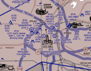
LA Helicopter Chart
For the fixed wing pilot, the LA Helicopter Chart & Routes most often flown are just about totally hidden in plain sight.
SCAUWG has proposed for some time that a hybrid chart be published combining the two worlds on the same page, at this time separate charts are issued for each platform. Each, with little reference to the other, possibly resulting in an out of sight, out of mind sensitivity, and consequently a false sense of security.
Though fixed wing traffic often fly the en route portions of their flights at higher altitudes than many helicopters choose, both the arrival and departure portions of fixed wing flight are understandably at low altitudes. Learning about the recommended helicopter arrival and departure routes will contribute to better situational awareness and safer flights.
6/16/2025 HELICOPTER ROUTES LAX CHANGES - Due to the recent Regan National Area accidents there have been inspired changes to the LA Airspace. The following has been issued by Los Angeles Tower: You can download a copy of this LTA HERE.

Close Up View: "...unavailable as of August 7, 2025"
Long Beach Airport has taken a particularly pro-safety position and has published inflight videos describing four sets of helicopter arrival/departure routes.
You can view the recommended KLGB helicopter arrival/departure routes HERE.
For the FAA List of available VFR Raster Charts that INCLUDES Helicopter Charts currently published Tap or Click HERE.
For the L A Basin Area VFR Helicopter Chart use the following link:
LA Helicopter Chart 05 16 2024 - Here
* Provided for convenience - please check the VFR Raster Chart reference above for the latest published edition. - Thanks!
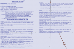
Chart Side Panel Description of Routes & Transitions: (Sample Only - Not for Navigation)
![]()
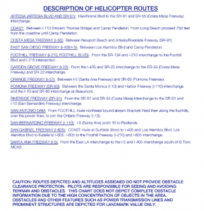
Chart Section Image (Sample Only - Not For Navigation)
LTA - OSC WSC BEACON CODES FOR HELICOPTERS OPERATING IN THE LA AREA:
Beacon Codes for Helicopter LA Area