This is the DEBUT VERSION of ChartCompare for use by SCAUWG.ORG visitors. For the 1st Time Ever:
COMPARE the NEW CHART EDITION to the
OLDER VERSION - FAST & EASY!

Have you noticed that airport symbols and VORs are being moved on our charts for better positional accuracy? Did you see that the isogonic lines have changed too?
Did you know that the FAA only publishes news about major chart changes? And, when was the last time you looked at the chart updates? - Well, you do not have to answer that question! - The fact is now you can get the information you need right away in a fast, easy to use, visual format! With ChartCompare you can instantly compare the new version of a navigational chart with the superseded version. Plus, using ChartCompare you can quickly locate the chart area you wish to investigate.
The fact is that the FAA charting division is quietly working to make our charts more accurate. Because of today's technology this has become possible. When the navigation charts were first introduced several decades ago, chart designers did the absolute best they could, but the results were a bit less than perfect. Even now, some airport locations and certain informational data points are to a degree flawed. Have you ever wondered why a GPS approach is still classified as a "non-precision" approach, while an ILS is defined as a "precision" approach? Our application ChartAware, can be used to illustrate some of these examples when one compares via an overlay, the high resolution satellite map location to a chosen chart location.
You can now check out our “swipe tool” apps that allow you to see these subtle changes on the Los Angeles Sectional, TAC, and Flyway charts. Just move the slider in the apps to see the changes between the old chart on the left and new one on the right! ChartCompare has been developed via the vision of Cartographer Mike Carson in co-ordination with the ChartAware Project developed by Mike Carson and Ron Berinstein.
You can begin by just clicking on one of the chart images below. That will take you to our ChartCompare page and you can begin your journey into the new, quick and easy to use world of staying up to date with the new FAA Charts!
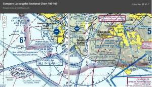
You Can Choose the Los Angeles Sectional Chart:
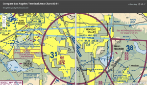
You Can Choose the Los Angeles Terminal Area Chart:
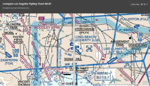
You Can chose the Los Angeles Flyway Chart: