


“Supporting Airports, Strengthening Communities”
Updates & Proposed Changes
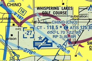
CLASS C CONFLICT with CHINO Traffic Pattern
The Los Angeles Terminal Area Chart (TAC) is updated every 56 days.
How to REPORT CHART ISSUES: "Aeronautical Inquiries"
Use this link: http://www.faa.gov/air_traffic/flight_info/aeronav/aero_data/aeronautical_inquiries
VFR CHART CHANGE NOTICES:
The Western Service Center Operations Support Group provided the attached “CHARTING NOTICE – 56-Day Visual Charts” from the FAA web site; https://www.faa.gov/air_traffic/flight_info/aeronav/safety_alerts/
The notice states; "Like other FAA Supplement, Enroute and Terminal products, each new visual navigation chart title panel will indicate the applicable AIRAC effective date range and no longer include an edition number.”
As the IFR charts on 56-day publishing schedule do not have an edition number, the new 56-day visual charts will be identified in the same way using effective dates.
Aeronautical Charting Meeting (Charting Group)
- The Aeronautical Charting Meeting (ACM) is a public meeting held two times every year. The purpose of the ACM is three-fold:
- Identify issues concerning safety and usefulness of aeronautical charts and flight information products/services.
- Discuss and evaluate proposals concerning aeronautical charts and flight information publications, digital aeronautical products, database coding, instrument flight procedures, and instrument flight procedure development, policy, and design.
- Provide an opportunity for government and interested participants to brief and/or discuss new navigation concepts, terminal instrument procedures (TERPS) policy/criteria changes, and charting specifications and methodologies.
The Aeronautical Charting Meeting is divided into two groups — the Instrument Procedures Group (IPG) and the Charting Group (CG) See Order 7910.5.
The CG portion of the ACM includes briefings and discussions on recommendations regarding aeronautical charts and flight information products/services. Please visit the ACM Instrument Procedures Group Web Site for information regarding Instrument Procedure issues.
The meeting is a facilitated discussion of new and outstanding topics. The status of an open issue will be reported from meeting to meeting until a resolution is reached, at which point the issue will be closed.
We have rescheduled ACM 25-02 to January 12-15, 2026, via Zoom. Due to scheduling constraints, we are switching the order of the meeting and will conduct the Charting Group (CG) the first 2.5 days and the Instrument Procedures Group (IPG) the last 1.5 days.
The dates and times (all times are Eastern) for the meeting will be:
- Monday, 12 January, 1000 – 1700: CG
- Tuesday, 13 January, 1000 – 1700 CG
- Wednesday, 14 January 1000 – approximately 1200: CG (will continue the CG until completion)
- Wednesday, 14 January approximately 1300 – 1700: IPG (will begin after CG is completed)
- Thursday, 15 January, 1000 – 1700: IPG
Details regarding how to register and participate in the meeting will be provided in a separate email one week before the meeting. For the Instrument Procedures Group, minutes of prior meetings, history of closed and open items, etc., are available on the website at ACM IPG Group. For the Charting Group, minutes of prior meetings, history of closed and open items, etc., are available on the website at ACM Charting Group.
-
Rune Duke, Aviation Safety, Flight Technologies & Procedure Division, Flight Procedures & Airspace Group Division Feedback: 9-AWA-AVS-AFS-400-flight-technologies-procedures@faa.gov
Flight Technologies & Procedures Division webpage
Jennifer L. Hendi, Aeronautical Information Services, AJV-A2, Visit Aeronautical Information Services Here
Aeronautical Charting Meeting (ACM) — Charting Group
- This information has recently been updated, and is now available.
- ACM 25-02 CG Minutes, January 12-14, 2026 (PDF)
- Aeronautical Information Services requests feedback on the modernization initiative in support of the FAA's Aeronautical Charting Program (PDF). Please provide feedback to: 9-amc-avs-acm-info@faa.gov
Next Meeting
- The next meeting will be held April 20-23, 2026.
Aeronautical Charting Meeting – (Charting Group)
New Recommendation Documents for Upcoming ACM (CG)
Submission deadline for ACM 26-01: March 20, 2026.
Submitted new Recommendation Documents:
- C_25-01-396 Charting of Radial Distances for Class C A*irspace (PDF)
- C_25-01-397 Mountain Pass Routes (PDF)
- C_25-01-398 Charting of Non Standard CPDLC Logon Information (PDF)
- C_25-01-399 Charting of Communications on SIDs and STARs (PDF)
- C_25-01-400 Publish ATCAA boundaries (PDF)
- C_25-01-401 Quality Alert Metrics (PDF)
- C_25-01-402 Airport Remarks Format (PDF)
- C_25-01-403 Julian Dates in the Chart Supplement (PDF)
- C_25-01-404 Unused Marker Beacons in NASR (PDF)
- C_25-01-405 Runway End Safety Areas (PDF)
- C_25-02-406 VOR Checkpoints in Chart Supplement (PDF)
- C_25-02-407 IAP Profile Distances after FAF (PDF)
- C_25-02-408 IFR Visual Departures (PDF)
- This information has recently been updated, and is now available.
Aeronautical Charting Meeting for U.S. Federal Aviation Administration: information has recently been updated and is now available.
- New submission deadline for ACM 26-01 Closed
- New submission deadline for ACM 26-02 August 21, 2026
- Submitted new Recommendation Documents
Aeronautical Charting Meeting – (Charting Group)
FLIGHT in the INLAND EMPIRE - PRECAUTION!
Pilots should be aware that this is a busy flight area. Besides the VFR traffic (often with some legacy aircraft), and IFR traffic there is a multitude of IFR training flights flown in the area located around the Paradise VORTAC (PDZ). Extreme caution should be exercised. Be on the ook out for jet arrivals into SBD,
AIRSPACE NEWS & PROPOSALS & CHART NEWS
03/31/2026 EASA: Narrow Mideast Corridors Increase Operational Risk - From AvWeb - "European regulators say conflict-related airspace restrictions are increasing congestion and risks. - The European Union Aviation Safety Agency (EASA) has begun warning that Iran conflict-related airspace restrictions and advisories in the Middle East are creating added operational risk by pushing more traffic into a smaller number of usable routes. As fewer corridors between Europe and Asia are available, there is also less flexibility for reroutes and more pressure on traffic flows.
That concern comes as EASA and other agencies advise operators not to fly in the airspace of Bahrain, Iran, Iraq, Israel, Jordan, Kuwait, Lebanon, Qatar, the United Arab Emirates and large portions of Saudi Arabia and Oman, with limited exceptions in specified higher-altitude segments of Saudi and Omani airspace. - EASA has said the region remains exposed to “spill-over risks, misidentification, miscalculation and failure of interception procedures,...” Continue Here.
03/25/2026 Amazon Breaks From Commercial Drone Industry on Safety - From FLYING - "Company’s Prime Air unit withdraws from the Commercial Drone Alliance. - Amazon’s Prime Air drone delivery business has withdrawn from arguably the country’s largest and most influential drone advocacy group over a “fundamental and irreconcilable disagreement” on safety, it wrote in a letter viewed by FLYING. - First reported by Reuters, the letter marks Prime Air’s formal departure from the Commercial Drone Alliance (CDA) due to clashing perspectives on the FAA’s consequential Part 108 proposal, which contains provisions for beyond visual line of sight (BVLOS) operations. - The proposal generated thousands of comments, many criticizing the FAA for going too far—and some for not going far enough." Complete Article Here
03/25/2026 Chart Error Pauses New VFR Routes at Seattle’s Boeing Field - From FLYING - "Pilots should continue to use 2021 procedures due to clerical mistake on updated TAC. - If you’re flying into King County International Airport-Boeing Field (KBFI) using the published VFR procedures, take note. Officials say there’s a clerical error on the VFR Terminal Area Chart (TAC) released March 19, and pilots should continue using the routes that have been in place since 2021 until further notice." Read More Here.
03/19/2026 Going to Sun & Fun in Lakeland, Fla? Click here to see the NOTAM on the FAA’s website. You can also access the NOTAM at FlySNF.org/Aerospace-Expo/The-NOTAM-Is-Here. This page also includes other information about the show, including tips on flying in, information about the Pilot Welcome Center, and more.
03/19/2026 FAA Ends ‘See and Avoid’ In Mixed Helicopter Traffic Areas - From AvWeb - "The FAA has suspended visual separation for helicopters and fixed-wing aircraft in high-traffic airspace. - The Federal Aviation Administration (FAA) is suspending the use of visual separation between helicopters and fixed-wing aircraft in some of the nation’s busiest airspace, requiring controllers to instead use radar to maintain standard separation, the agency announced Wednesday.
The change applies to Class B and Class C airspace as well as Terminal Radar Service Areas, where helicopter traffic frequently crosses arrival and departure paths near major airports.
Under the new general notice (GENOT), controllers will no longer rely on pilots to “see and avoid” other aircraft in these environments. Instead, they will actively manage traffic using defined lateral or vertical separation standards.- Federal officials said the move follows a year-long safety review that identified an overreliance on visual separation in high-traffic areas—particularly where helicopter and airline operations intersect." Read more about this important notice Here.
03/13/2026 Senator Raises Safety Concerns Over Anti-Drone Laser System - From AvWeb - "Recent incidents near Texas prompt questions about coordination between federal agencies and aviation safety. - Sen. Maria Cantwell, the U.S. Senate Commerce Committee’s top Democrat, said recent incidents involving a laser-based counter-drone system raised concerns about aviation safety and coordination among federal agencies. In a letter to the U.S. Department of Defense, the Federal Aviation Administration and the U.S. Department of Homeland Security, Cantwell wrote that the events highlighted what she described as shortcomings in interagency communication." - Conclusion Here.
03/12/2026 Honeywell Gains FAA Approval For New Aspen RNAV (RNP) Approach - From AvWeb - "Honeywell’s new RNAV (RNP) approach into Aspen (KASE) Runway 15 is now FAA-approved, providing lower minimums, a stabilized descent, and guided missed approach for safer operations. - Honeywell has received FAA approval for a new RNAV (RNP) approach into Aspen/Pitkin County Airport (KASE) Runway 15, one of the country’s most challenging mountain airfields. The move promises safer, more predictable access to the high-altitude airport, especially in tricky weather. - The Aspen RNAV (RNP) N Rwy 15 procedure offers lower minimums and a stabilized descent compared with the “dive and drive” approaches pilots have traditionally used to navigate the canyon. Minima are set at 537 feet height above touchdown with 1¼‑mile visibility, with a 3.5° approach angle designed to reduce pilot workload in marginal conditions." Read About it Here.
03/11/2026 LA TAC CHART UPDATE - LOS ANGELES SPECIAL FLIGHT RULES AREA - FLIGHT FOLLOWING FREQUENCIES: The Frequencies upon exiting the Route in order to rejoin Flight Following Service have been sought after. The lines below have added to the TAC Chart Special Flight Rules description: (Reproduced from the March 19, 2026, LA TAC Chart)

03/11/2026 Drones Need Their Own Rules - From AvBrief - "A drone program at the New Mexico State University (NMSU) test site caught my attention. They are doing safety work: Find small drones, track them, and reduce collision risk. - The problem zone is surface to 400 feet AGL. Helicopters work there. Manned aircraft pass through on climb and descent. Now add the drone stack and more low-altitude traffic coming, including eVTOL operations. Same layer. More mixing. - See and avoid does not hold up well here. Drones are small and they blend into the ground. In the drone zone you are also watching terrain, wires, landing spots, and other traffic. It can be harder than higher airspace because everything is closer and the targets are smaller. - ATC may not see the drone at all. Most drones are not on ADS-B, so you usually do not get a target on your screen. That is why I keep pushing DFR / DFR-B." Find out More about this very Important Safety Problem Here.
03/11/2026 RTX Seeks Larger Role in FAA’s $12.5B ATC Overhaul - from FLYING - "Company will reportedly pitch its common automation platform to consolidate existing ATC systems. - RTX, which in January received a $438 million contract to help the FAA replace hundreds of antiquated radar systems, is reportedly vying for an even larger chunk of the $12.5 billion Congress has allocated for the agency’s Brand New Air Traffic Control System (BNATCS) effort. - On Tuesday at RTX facilities in Washington, Collins Aerospace officials demonstrated a system designed to unify fragmented ATC data sources, which the company, per FlightGlobal, will pitch to the FAA as the BNATCS common automation platform (CAP). - The regulator has selected a prime integrator—Peraton, which will oversee the entire effort—and handed out contracts to RTX and others for various subtasks. But it still seeks a CAP to aggregate data from the disparate en route and terminal systems that are used to track and manage aircraft." - Continue Here.
03/10/2026 Reported today by Southern California Airspace Users Working Group (independent from SCAUWG.ORG) is that the ad-hoc committee assigned to investigate a proposal for consideration by the FAA, to better design the Ontario Class C airspace. Chairperson Eve Lopez of CalPilot announced the committee's result that was determined to better orchestrate the airspace to accommodate safer operations at Chino and Cable airports whilst maintaining the integrity needed at Ontario. Changes have been submitted to the FAA for consideration. Should they be accepted a future public comment period will ensue that will detail the chosen modifications to the current design determined to be beneficial be the FAA. SCAUWG, the group, applauded Eve Lopez for her dedicated guidance. The proposed airspace makes both boundary and shelf altitude changes and looks like this:
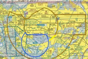
PROPOSED ONT CLASS C MODIFICATION
03/06/2026 FAA CHARTING NOTICE
To: Users of: All Aeronautical Products and Digital Services
From: Aeronautical Information Services, Mission Support Services, AJV-A
Subject: Discontinuation of Selected Charting Products and Services Beginning May 14, 2026
Please be advised that the FAA is discontinuing the following products:
Gulf of America and Caribbean Planning Chart
IFR Gulf of America Vertical Flight Reference
The final publication date for these products will be March 19, 2026. As the current versions of
the above products expire on May 14, 2026, they will be removed from the FAA website.
Concerns about the impacts to the safety and efficiency of the airspace can be reported on the
web or by phone using the FAA Hotline:
View Aeronautical Information Services Safety Alerts and Charting Notices HERE
for awareness of chart and data corrections. A page subscription service is available.
For awareness or participation in a public forum to identify issues concerning the safety and
usefulness of aeronautical charts and flight information products/services, and discuss change
proposals to specifications and methodologies, visit the Aeronautical Charting Meeting (Chart
Group) at (https://www.faa.gov/air_traffic/flight_info/aeronav/acf/ ).
A page subscription service is available.
For aeronautical data or charting inquiries visit the Aeronautical Information Portal
https://nfdc.faa.gov/nfdcApps/controllers/PublicSecurity/nfdcLogin
3/04/2026 A FAASTeam Webinar was held on Feb 24/25 that feature SBD ATC Procedures. Very important, as its location and the air traffic can also influence safe flight at REI. Addressed during the webinar were Four (4) SBD LTAs. For everyone's safety these were designed to inform the pilot community of the ATC PROCEEDURES AT SBD. You can access and view them by Clicking Here
03/04/2026 FAA Radar Data Program Launches at UAS Test Site - From AvWEb - "North Dakota site first non-federal entity to receive unfiltered FAA surveillance feed. - The FAA has activated a radar data sharing initiative with the Northern Plains UAS Test Site in Grand Forks, North Dakota, enabling the integration of federal radar information into the state’s Vantis beyond visual line-of-sight (BVLOS) system. The agreement makes the test site the first non-federal participant to access the FAA’s unfiltered radar data feed.
FAA Deputy Administrator Katie Thomson announced the agreement during the UAS Summit & Expo in Grand Forks in 2024, describing it as a government-to-government release of surveillance data intended to support the integration of unmanned aircraft systems into the National Airspace System." - More details Here.
3/03/2026  To view and read the LTA you may click on the image above.
02/25/2026 Vertical Aerospace Eyes Miami-Dade for eVTOL Network - From AvWeb - "Federal planning, local groundwork and industry partnerships frame potential Miami-area AAM operations. - Vertical Aerospace said last week that it is exploring a network of regional electric aircraft operations in South Florida centered on its Valo eVTOL. - The company’s South Florida planning follows recent federal action to formally position advanced air mobility as a future transportation mode in U.S. cities and regions. A national strategy document released in December outlines a coordinated federal effort to accelerate development and deployment of these operations over the next decade, including demonstrations and initial services expected later this decade." Read the whole article Here.
02/25/2026 House Fails To Advance ROTOR Act - From AvWeb - "Measure on ADS-B equipage falls short of two-thirds threshold. - Read about the rotor act that would require ADS-M IN in certain airspace, and the current political circumstances, HERE.
02/23/2026 Alaska Aviation Weather Unit Updates Surface, SIGWX Charts - From AvWeb - "Changes take effect Feb. 22 as production moves to new system. - Changes take effect Feb. 22 as production moves to new system. -
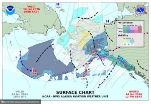
The National Weather Service’s Alaska Aviation Weather Unit will implement updates to its Surface and Significant Weather charts beginning Feb. 22, including changes to chart appearance, resolution and production methods. Changes to the charts were proposed last year.
According to a National Weather Service Service Change Notice, the revised Surface chart will incorporate higher-resolution data, probabilistic precipitation information and improved consistency with other NWS products while transitioning production off a legacy system. Surface charts will continue to be issued four times daily at 00z, 06z, 12z and 18z, and file formats will change from GIF to PNG." - Continue Reading Here
02/19/2026 New Approach Procedure Available at Teterboro Airport Feb. 19 - From NBAA - "New Jersey’s Teterboro Airport (TEB) will introduce a new instrument approach procedure (IAP), RNAV (GPS) RWY 01, beginning Feb. 19 at 0701Z. While offering the advantage of lateral and vertical guidance to the runway, the new IAP notably introduces a visual guidance fix (VGF) and visual segment concept at TEB.
NBAA strongly encourages operators to become familiar with a VGF and an extended visual segment by reviewing
InFO 24005, Instrument Approach Operations with a Visual Guidance Fix (VGF) and an Extended Visual Segment.
The procedure will be advertised on ATIS whenever the approach is in use, and pilots should advise ATC if they are unable to accept it." Continue Here.
02/12/2026 GAO Flags Gaps in Drone Airspace Safety - From AVweb - "Report says FAA must clarify roles, milestones for aircraft communication and avoidance. - A new federal report from the Government Accountability Office (GAO) studied the present state of drone integration into the national airspace system and reported a number of safety gaps, even as beyond visual line of sight (BVLOS) drone flights are expected to rise substantially in the near future.
The FAA is working on proposed BVLOS rules and is engaged in relevant research, but the GAO’s report suggests that the rise of BVLOS operations is outpacing the development of an adequate regulatory framework. According to the report, no planning that presently exists deals directly enough with the specific actions, responsibilities or technical milestones that will be required in order for drones to communicate with and avoid other aircraft in a consistent and standardized way during routine operations.
The report points out some of the limitations inherent in today’s detect-and-avoid approaches. It notes that existing technologies rely heavily on systems that cannot support large-scale integration on their own. According to GAO, the FAA has articulated a long-term vision for an information-centric airspace in which aircraft share two-way position data electronically, but planning so far lacks the detail needed to guide implementation and adequate systems are not yet in place for this to be accomplished successfully yet." Read More Here.
02/11/2026 El Paso airspace closure was tied to Mexican cartel drones, officials say, after FAA lifts 10-day grounding - CBS News - "The Federal Aviation Administration announced Wednesday morning that it has lifted the closure of El Paso's airspace just hours after it said it was halting all flights in and out of the airport for 10 days for what it called "special security reasons." U.S. officials later said the closure was tied to a "cartel drone incursion." - Administration officials told CBS News that the closure was triggered by Mexican cartel drones breaching U.S. airspace. The officials said the Department of Defense took action to disable the drones, and that the FAA and defense officials have determined there is no current threat to commercial travel." - See the CBS Video Coverage Here.
02/04/2026 NBAA Lauds House Passage of Appropriations Bill Reflecting Industry Priorities - From NBAA - "Other NBAA-supported priorities in the THUD bill include recommendations for increased funding for FAA airport improvement grants and the hiring of new air traffic controllers, agency safety inspectors and engineers; expansion of alternative fuels research and production of sustainable aviation fuel and the safe implementation of expanded unmanned aircraft system (UAS) and commercial advanced air mobility (AAM) operations." - PR Release Here.
01/31/2026 NTSB Probable Cause Cites FAA Lapses in DCA Collision - From AINonline - Hearing resulted in 50 recommendations to the FAA, U.S. Army, and other agencies. During the NTSB hearing on Jan. 29, 2025 regarding the midair collision of a U.S. Army Sikorsky UH-60L Black Hawk helicopter and a PSA Airlines CRJ700 about a half mile southeast of Ronald Reagan Washington National Airport (KDCA), the board released its probable cause for the accident.
“We determined that the probable cause of this accident was the FAA’s placement of a helicopter route in close proximity to a runway approach path; their failure to regularly review and evaluate helicopter routes and available data; and their failure to act on recommendations to mitigate the risk of a midair collision near [KDCA], as well as the air traffic system’s overreliance on visual separation in order to promote efficient traffic flow without consideration for the limitations of the see-and-avoid concept.”
During yesterday’s NTSB hearing on the Jan. 29, 2025 midair collision of a U.S. Army Sikorsky UH-60L Black Hawk helicopter and a PSA Airlines CRJ700 about a half mile southeast of Ronald Reagan Washington National Airport (KDCA), the board released its probable cause for the accident.
“We determined that the probable cause of this accident was the FAA’s placement of a helicopter route in close proximity to a runway approach path; their failure to regularly review and evaluate helicopter routes and available data; and their failure to act on recommendations to mitigate the risk of a midair collision near [KDCA], as well as the air traffic system’s overreliance on visual separation in order to promote efficient traffic flow without consideration for the limitations of the see-and-avoid concept.” More Here
01/31/2026 Burbank Airport could be next scene of mid-air crash, airlines warn NTSB - From ABC News - "BURBANK, Calif. (KABC) -- The chair of the National Transportation Safety Board on Tuesday expressed concerns over the dangerous possibility of the next deadly mid-air collision happening at Hollywood Burbank Airport. - The NTSB chair says its commercial airlines that are sounding the alarm, and says the FAA should take the warnings from airlines seriously. - "I keep hearing about other areas in the airspace where they are concerned. Burbank is one where commercial airlines have called me to say the next mid-air is going to be at Burbank, and nobody at FAA is paying attention to us," NTSB Chair Jennifer Homendy said at a hearing, referring to the Federal Aviation Administration. "So, whether it is involving helicopters or not, people are raising red flags, and why aren't people listening? The FAA has to ensure safety. That is their job."
Tuesday's hearing was part of the investigation into a deadly mid-air crash near Washington, D.C. last year that left 67 people dead and involved an Army helicopter and an American Airlines plane. - Whether it's helicopters like the deadly crash in D.C., or private aircraft, the concern is the amount of traffic coming and going from Burbank Airport and Van Nuys Airport in a relatively small airspace. Both airports are extremely busy. - According to the Aviation Safety Reporting System, there have been six near mid-air collisions at Burbank Airport since Jan. 1, 2021. The NTSB is demanding that the FAA take action." Read More Here.
Webmaster Note: Van Nuys East Pattern was lowered as of 1/05/2026, See VNY LTA Here
01/31/2026 Reprinted from Reddit - author: climb-via-is-stupid - This Material is the opinion of the author, SCAUWG.ORG has not verified the content at this time.
The new terminal is being built specifically because the current does not meet runway safety standards (it’s too close to the runways) and to a lesser extent does not meet earthquake standards.
The final approach for RWY8 has always been a shitshow for lack of a better phrase, the separation for aircraft coming in and the Van Nuys traffic pattern is 1000’ if everyone is doing what they’re supposed to be doing. Which if you’re familiar with the Swiss Cheese model, is already two really big holes that thankfully haven’t lined up yet. Unfortunately there’s not really much that can be done because either you a: make the runway longer on the Hollywood Way side so you can increase the glide slope angle (landing angle), or B: make the coordination between BUR and VNY so insanely convoluted that both airports end up severely hampering their operations. Obviously B would be ideal but money talks and the airlines and general aviation users at VNY would scoff at that. So basically there’s no real ideal to handle that because it’s something that’s already been talked about in the long long ago. Maybe since the DCA crash it’s been brought up again.
As to the helicopter traffic that’s in and around both airports and the entirety of the SFV, I mean it kind of just goes back to B from the previous paragraph. We do our best to help out LAPD, LASD, LAFD and LACoF with their operations and we have always erred on the side of caution (it’s kind of our main fucking job to prevent collisions), but the tourist and training helicopters are priority last on the list when it comes any kind of accommodation.
What I’m getting at is is there a potential for a disaster, absolutely. But the mitigations that are currently in place and the good work of the controllers at both BUR and VNY is not something I would really call in to question or even worry about. It’s not great to be like “well it hasn’t happened yet” because I had several close calls there in my time simply because an aircraft was too low on approach or someone at VNY busted their altitude in the traffic pattern. But each and every time it’s been caught by someone in the respective Tower.
All that said, the Swiss cheese model exists for a reason and we’re always looking for ways to mitigate the holes lining up. The safest way is to have no one fly, that’s unrealistic for the amount of money both airports bring in. The next is to turn it into a “one in one out” operation which again is unrealistic because “money”. So right now it’s status quo. But if there’s one thing that’s true in any safety related field, it’s that new regulations are usually written in blood. Maybe the FAA increases separation standards for helicopters vs fixed wings in congested areas. But that’s above my pay grade,"
01/07/2026 New York Helicopter Route - Effective Jan. 22, 2026 - ChartRevise Eastern Long Island Helicopter Route Chart margin tabulations to include Class C Approach Control Frequencies and Special Use Airspace information. See the 26-01 VIS Charting Notice (PDF) for complete information.
01/04/2026 Thousands stranded across Europe as Greece airspace disrupted - From BBC - Mostly Athens - Story Here

Passengers sleep on the floor, after flights were delayed and cancelled when the airspace was closed due to U.S. strikes on Venezuela overnight, at Rafael Hernandez International Airport in Aguadilla, Puerto Rico.
01/03/2026 Airlines cancel dozens of Caribbean flights after US attacks on Venezuela - From CNBC - "Airlines canceled flights throughout the Caribbean on Saturday following U.S. strikes on Venezuela after the Federal Aviation Administration ordered commercial aircraft to avoid airspace in parts of the region. - President Donald Trump said Saturday the U.S. strikes resulted in the capture and removal of Venezuela's President Nicolas Maduro. - U.S. airlines canceled dozens of flights to airports in Puerto Rico and Aruba, according to flight tallies from FlightAware and carriers' sites." "American Airlines is aware of the airspace closures in the Eastern Caribbean that were issued in the middle of the night and is closely monitoring the situation with the FAA," the carrier said in a statement. "We are making schedule adjustments as necessary with the safety and security of our customers and team members top of mind." - Southwest Airlines and JetBlue Airways also showed cancellations in the Caribbean." READ MORE HERE.
12/27/2025 Holiday travelers face flight delays as FAA restricts airspace nationwide amid winter weather: report - From Fox News - "Travelers could face major delays as airports may be overwhelmed with millions of travelers during the holiday weekend. - The Federal Aviation Administration (FAA) on Friday issued at least eight separate airspace flow restrictions, the Daily Mail reported. - The series of Airspace Flow Programs (AFPs) could impact major airports in the United States and Canada during one of the busiest travel days of the year. Some delays could reach more than six hours, the outlet said." Full story Here.
12/23/2025 ‘We’re Going to Get the Flying Cars’: Unpacking the AAM National Strategy - From FLYING - "Transportation Department unveils roadmap for integrating electric propulsion, powered-lift, autonomy, and other aviation technologies. - The U.S. Department of Transportation (DOT) on Wednesday unveiled a roadmap intended to usher in a new generation of vertical takeoff and landing (VTOL) air taxis, autonomous cargo aircraft, electric airliners, and other advanced air mobility (AAM) aircraft. - Transportation Secretary Sean Duffy, FAA Deputy Administrator Chris Rocheleau, and Michael Kratzios, President Donald Trump’s chief science and technology policy adviser, were among federal officials present for the rollout of the AAM National Strategy. - The comprehensive, 10-year blueprint recommends steps to safely integrate AAM aircraft into the national airspace system (NAS) and cement the U.S. as the industry leader." Continue Here.
12/20/2025 NBAA Welcomes Subcommittee Approval of Bill to Reintroduce Supersonic Flight Over the US - From NBAA - PR Release "Washington, DC, Dec. 18, 2025 – The National Business Aviation Association (NBAA) welcomed today’s vote by the House Transportation and infrastructure Committee’s Subcommittee on Aviation to advance legislation to reintroduce supersonic flight over the United States. - H.R. 3410, the “Supersonic Aviation Modernization Act,” would require the Federal Aviation Administration (FAA) to issue regulations to legalize civil supersonic flight in the U.S., as long as the aircraft is operated to ensure that no sonic boom reaches the ground.
NBAA President and CEO Ed Bolen hailed the measure as commonsense legislation guided by recent advances that have shown great promise toward enabling transitions to Mach 1 that are nearly silent to those on the ground. - “By balancing innovative technologies with a continued focus on safety, this legislation is a smart solution to help advance what looks to be a revolutionary technology enabling rapid point-to-point connectivity,” Bolen said. “This measure will also enable the U.S. to maintain its competitive edge and remain the global leader in aviation.”
House Aviation Subcommittee Chairman Rep. Troy Nehls (R-22-TX) introduced the bill in May, with Rep. Sharice Davids (D-03-KS) co-sponsoring. U.S. Sen. Ted Budd (R-NC), a member of the Senate Committee on Commerce, Science, Transportation and Infrastructure, introduced companion legislation.
Review the full copy of H.R. 3410, the Supersonic Aviation Modernization Act.
With limited exceptions for military operations, supersonic flight over the U.S. has been prohibited since 1973 by the FAA over concerns about disruptiveness from supersonic reverberation. - However, the industry has made strides to mitigate that issue for civil operators. NASA recently launched flight testing of the experimental Lockheed Martin X-59 QueSST, designed to reduce the perceived supersonic boom at ground level to a “thump” similar to the sound of a car door closing. - Earlier this year, Boom Supersonic announced that both supersonic flights of its XB-1 demonstrator aircraft included multiple “boomless cruise” runs at supersonic speeds. While not specifically designed to reduce sonic booms, the aircraft utilized specialized, high altitude and high-speed flight profiles and real-time weather data to refract the sonic boom upward, away from the ground.
The NBAA Emerging Technologies Committee supports the advancement of supersonic flight and other aviation advancements, including unmanned aircraft systems, advanced air mobility, unmanned traffic management, commercial space and other future technologies and associated infrastructure representing significant opportunities for business aviation stakeholders.
Credit: Dan Hubbard dhubbard@nbaa.org
12/17/2025 AOPA Asks Feds to Intervene in Dispute With Tribal Authorities - From AVweb/AOPA - "Pilot’s emergency landing leads to legal standoff over airspace jurisdiction on Red Lake Reservation. - AOPA said Wednesday it is urging federal officials to assist in the recovery of a vintage airplane seized by the Red Lake Nation following an emergency landing on tribal land in northern Minnesota. In a letter sent December 17 to Transportation Secretary Sean Duffy and Interior Secretary Doug Burgum, AOPA President and CEO Darren Pleasance described the October 15 incident involving a 1946 Stinson 108 as a situation with broader implications for aviation safety. - Tribal impound basis:
Smedsmo was en route to Bemidji Regional Airport when the engine failed at around 3,500 feet over Lower Red Lake. He managed to safely land on a road within the boundaries of the Red Lake Indian Reservation, but tribal authorities impounded the aircraft. The tribe cited its Resolution No. 59-78, a 1978 measure originally meant to fight back against a proposed military training route over the tribal territory. According to that measure, flight over Red Lake Nation lands is prohibited below 20,000 feet, although no such restriction is noted on federal aeronautical charts." More Here.
12/17/2025 Bedford Discusses ‘State of American Aviation’ in House Hearing - From AVweb - "Lawmakers review post-crash actions as agency details modernization plans. - Federal Aviation Administration administrator Bryan Bedford appeared before the House Aviation Subcommittee on Tuesday to outline the agency’s assessment of the U.S. aviation system and steps taken following a fatal January collision near Reagan Washington National Airport. The hearing, titled “The State of American Aviation,” brought together lawmakers and agency leadership to review airspace safety, air traffic control staffing, and the pace of long-planned modernization efforts. - Safety Measures Following January Collision:
Bedford, who took office in July, said January’s deadly accident between a CRJ700 and a military Black Hawk helicopter near DCA that killed 67 people prompted immediate operational changes and a broader review of risk management practices. - “The DCA accident was a defining moment for the FAA and for the country,” Bedford said in prepared testimony. - During the hearing, Bedford pointed to new helicopter restrictions around Washington-area airports, along with..." More Here.
12/17/2025 US government admits negligence in helicopter-plane collision that killed 67 in Washington - From AP - "WASHINGTON (AP) — The U.S. government admitted Wednesday that the Federal Aviation Administration and the Army played a role in causing the collision last January between an airliner and a Black Hawk helicopter near the nation's capital, killing 67 people. - The official response to the first lawsuit filed by one of the victims’ families said that the government is liable in the crash partly because the air traffic controller violated procedures about when to rely on pilots to maintain visual separation that night. Plus, the filing said, the Army helicopter pilots' “failure to maintain vigilance so as to see and avoid” the airline jet makes the government liable." Continue Reading Here.
12/16/2025 JetBlue Has Near Miss with US Air Force Jet Outside Venezuela - From AVweb - "Pilot notifies air traffic controllers about ‘outrageous’ close call. - According to AP, JetBlue Flight 1112 was taking off from Curacao to New York City’s JFK airport when the military plane crossed its flight path. U.S. military aircraft have been active in the region amid ongoing tensions between the U.S. and Venezuela – whose coastline is roughly 40 miles south of the Caribbean island nation." Full article Here.
12/12/2025 NTSB Warns Congress Over DCA Airspace Provision - From AVweb - "Letter from NTSB agency chair cites concerns tied to January midair collision. - NTSB Chair Jennifer Homendy sent a letter to congressional leaders on Wednesday, urging the removal of a provision in the 2026 National Defense Authorization Act. Homendy wrote that Section 373, despite adding language around alerting systems, would in practice allow military departments to conduct rotary wing training missions in the Washington, D.C., Metropolitan Area Special Flight Rules Area under conditions similar to those in place before the Jan. 29 midair collision near Ronald Reagan Washington National Airport.
Homendy wrote that Section 373 of the NDAA would rely on warnings compatible with commercial aircraft TCAS systems. She noted that TCAS is inhibited during low-altitude descent to avoid nuisance alerts and did not prevent the crash despite issuing an alert nearly 20 seconds before impact, according to the agency’s findings" Finish Reading Here.
12/01/2025 Privatize or modernize? Two views on the future of air traffic control - From NBAA - "In an op-ed published by several news outlets, NBAA President and CEO Ed Bolen said a landmark ATC investment will usher in a new era for aviation." Read BOTH opinions Here
12/01/2025 55 additional airports added to FAA’s FlightLine Surface Awareness initiative - From General Aviation News - "The FlightLine SAI, which is already operational at 14 FAA-towered airports in the National Airspace System (NAS), provides real-time, precise depictions of all ADS-B equipped aircraft and vehicles on the airport surface, enabling proactive management of potential conflicts, especially critical during low-visibility conditions, company officials explained." Read More Here.
11/30/2025 NATO Intercepts Unique Russian ‘Black Pearl’ Over Eastern Europe - From FLYING - "Italian Eurofighter Typhoons scrambled to block a specialized Tupolev Tu-134UBL. - NATO jets intercepted a unique Russian Tupolev Tu-134 aircraft—nicknamed “Black Pearl” by Western security experts—over the Baltics earlier this month. - In a statement, NATO Allied Air Command said Italian Eurofighter Typhoons stationed at Ämari Air Base in Estonia as part of an airspace policing mission intercepted several Russian military aircraft and escorted them out of the area. Among the Russian assets was the Black Pearl, which is a Tu-134UBL, a military variant of the Tu-134 passenger aircraft." Continue Here.
11/29/2025 Flight tracker shows Venezuela airspace after Trump orders shutdown - From The Independent - VIDEO - "Flight Radar shows airlines diverting away from Venezuela after Donald Trump told airlines to consider the airspace closed." - Watch the VIDEO Here.
11/27/2027 FAA Expects Busiest Thanksgiving Travel Period in 15 Years - FAA - "Washington, D.C.- The Federal Aviation Administration is gearing up for the busy Thanksgiving travel time and is ready to get more than 360,000 flights to their destinations. - We expect this Thanksgiving holiday travel period to be the busiest in 15 years, with Tuesday, Nov. 25 being the peak travel day with more than 52,000 flights. - “Thanks to the dedication of our air traffic controllers and every FAA employee, we are ready for the holiday rush and take pride in helping travelers reach their friends and families during this important time of year,” said FAA Administrator Bryan Bedford. “I am deeply grateful to our entire FAA team. Even through a period of record-high traffic, their unwavering commitment keeps the system running safely.” Continue Here
11/27/2025 Current Chart Change: This information has recently been updated and is now available.
- Baltimore-Washington Helicopter Route Chart - Eff. Jan 22 2025
Safety Alerts, Charting Notices & Data Product Notices
REMINDER: You can visit the FAA.GOV Safety Alerts and Chart Changes Page via Our Menu Tab (fast & Easy)
(Excerpt from SCAUWG.ORG)
11/26/2025 FAA’s Bedford: ATC Apps Key to Innovating Faster - From AINonline - "FAA is eyeing a four-layer system - FAA Administrator Bryan Bedford told industry leaders at the Honeywell aviation leadership conclave last week in Washington, D.C., that the agency needs an ATC system based on iPad-like applications. New tools, including commercial off-the-shelf systems, will be used, Bedford said. - “We have to move from an analog National Airspace System to a digital NAS,” he said. "How data is delivered is less relevant than rearchitecting the ATC system. - Bedford added ATC systems such as Stars and advanced technologies and oceanic procedures are some of the most sophisticated and safe on the planet. But these systems are not connected, and only..." Find Out More Here.
11/24/2025 US issues security NOTAM for Venezuelan airspace - From Flightradar24.com - "US issues security NOTAM for Venezuelan airspace
11/22/2025 FAA Seeks Solutions for New Air Traffic Automation System - FAA - Washington D.C. – The Federal Aviation Administration is looking to revolutionize how air traffic controllers receive flight data and move aircraft between facilities. - We’re seeking proposals to replace the current en route and terminal systems with a single, state-of-the-art platform for air traffic control called the Common Automation Platform (CAP). This is part of U.S. Transportation Secretary Sean P. Duffy’s plan to build a brand new air traffic control system.
“Under this Administration’s leadership, we’re going to give our hard-working air traffic controllers the technology they deserve at their fingertips,” said FAA Administrator Bryan Bedford. “CAP will strengthen safety, reduce delays, and ensure America’s airspace is prepared for the future.” - The FAA currently uses En Route Automation Modernization (ERAM) and Standard Terminal Automation Replacement System (STARS) systems to track and control aircraft. ERAM manages high-altitude flights at all 20 Air Route Traffic Control Centers (ARTCC), providing controllers with real-time data for safe and efficient aircraft navigation through en route airspace. STARS tracks and coordinates flights in Terminal Radar Approach Controls (TRACONs) facilities and air traffic control towers, and is used in sequencing, issuing conflict alerts and for weather updates for arriving and departing aircraft.
The CAP would unify these platforms into a single, modern and adaptable solution for air traffic controllers. This initiative will enhance resiliency and stability in the National Airspace System (NAS), allowing controllers to organize airspace more efficiently, and addressing the growing complexity and evolving demands of the future NAS. - Those interested should visit SAM.gov to learn about our request for information. - The FAA previously announced Requests for Information (RFIs) for a runway safety lighting system and vendor challenge to modernize the air traffic flow system. A Prime Integrator to manage the building of a brand new air traffic control system will be announced soon.
11/22/2025 Unpermitted Cranes Close Airport Daily - From AVweb - "Town weighs financial pressures while FAA reviews Dansville crane airspace violations. - Congressional interest has entered the struggle over the future of New York’s Dansville Municipal Airport as large, semi-permanent construction cranes continue to prompt runway closures and federal scrutiny. - Late last month, the situation first drew wider attention when the Aircraft Owners and Pilots Association (AOPA) urged North Dansville officials to address the unpermitted cranes installed by neighboring LMC Industrial Contractors, warning that the structures had already forced pilots to maneuver around them on final approach." More about this Problem Here.
11/20/2025 Bolen’s Summit Panel With Congressional Aviation Leaders Highlights Unity on ATC Modernization - From NBAA - VIDEO - At a Washington, DC industry forum held Nov. 19, 2025, NBAA President and CEO Ed Bolen was joined by two congressional aviation champions in underscoring the breadth and depth of support among government and industry leaders in building a brand-new air traffic control system. “The ATC modernization effort today is different than those of the past – more specific, more focused,” Bolen said in opening remarks for a panel he moderated with House Transportation & Infrastructure Aviation Subcommittee Chair Troy Nehls (R-22-TX) and Rep. Sharice Davids (D-3-KS). - Watch the VIDEO Interview Here
11/19/2025 From FLYING - "The FAA’s recent order banning all aircraft from operating within 1 nm of President Donald Trump’s Mar-a-Lago resort is causing headaches in Palm Beach and neighboring West Palm Beach, where residents say rerouted commercial flights are keeping them up at night and even rattling their Florida homes. - West Palm Beach City Commissioner Christina Lambert addressed widespread complaints from residents at a public meeting on Monday, according to WPEC-TV. She said the city was not given prior notice of the FAA’s decision and learned about it when the general public did." Find Out More Here
11/18/2025 FAA Restores Flights! From AP VIDEO see it Here.
11/16/2025 R2509 Special Use Airspace - The Marines have made a long-standing request for revisions. General Aviation will be affected unless modified. You can read some responses to the proposed airspace here by clicking on the image. You can read the proposed airspace changes Here.

11/17/2025 COMKMENT ON THE ABOVE BRC Position by an AOPA representative:
"I had a conversation last week with Shannon Welch from BRC to talk about what options might be feasible. I am working on getting a meeting with Rep Obernolte’s office to gauge his appetite for possible communications between them and FAA.
I agree their document has some really good points and analysis, but I disagree with their take on TFRs. AOPA does not favor their use in managing SUA for a variety of reasons.
I have been told the next round of comments (FAA review) will take place in the January or February timeframe (more likely February now, due to the shutdown)."
--- Jim McClay - Director, Regulatory Affairs - Airspace, Air Traffic and Security - Aircraft Owners & Pilots Association - 601 Pennsylvania Ave NW - North Building, Suite 250 - Washington, DC 20004 - 202-509-9515 | www.aopa.org
11/15/2025 One Controller at Miami Tower: Air Traffic Control Crisis - From AVweb - "Guest Post: Unpaid and overworked air traffic controller's strain to keep America’s skies safe amid the shutdown. - Miami International Airport, late at night: I was sitting at the hold-short line trying to call for clearance, but the frequency was impenetrable. One controller; just one, was working clearance, ground and tower at the same time at one of the busiest airports in the United States. His voice never stopped. Every second was another instruction, another aircraft to move, another conflict to untangle.
Out on final, a Boeing 787’s captain kept trying to request landing clearance. He couldn’t get in either. His calls were swallowed in the constant stream of radio traffic as the lone controller tried to run an entire airport by himself, taxiways, approaches, departures, all of it. - This wasn’t a dramatic movie moment. It was a real-world snapshot of an air traffic control system stretched far past safe limits, now pushed even closer to failure by the ongoing U.S. government shutdown. Read the completion Here.
11/11/2025 FAA Bars GA Flights from 12 Airports - From AVweb - "NBAA calls for end to government shutdown as NOTAMs ground GA flights at 12 hubs. - The National Business Aviation Association (NBAA) is warning of widespread operational impacts following new federal restrictions effectively prohibiting business aviation flights at 12 of the nation’s busiest airports beginning Monday. The order, issued as a series of NOTAMs, closes access to facilities including Atlanta, Chicago O’Hare, Dallas Fort Worth, Los Angeles International and New York’s JFK. The NOTAMs specify that the airports are closed to all general aviation (GA) and non-scheduled aircraft, though they make certain exceptions for based aircraft, emergency, medical, law enforcement, firefighting and military operations." Read More Here
11/09/2025 ICYMI: Playback Now Available - NBAA News Hour: Making Sense of NAS Impacts Amid the Government Shutdown - On Nov. 6, NBAA hosted an important webinar, “NBAA News Hour: Making Sense of NAS Impacts Amid the Government Shutdown.” - The 8 p.m. ET start of the webinar was timed to follow the FAA’s release of an order detailing planned changes for National Airspace System (NAS) management in light of the government shutdown. - If you missed the live session, a recorded playback is now available to watch.
The timely discussion provides important information on the FAA’s planned changes to management of the NAS, including potential implications for business aviation operations. Don’t miss the details provided in this webinar about how the plans could impact your next mission, and what’s next for our industry. Access the playback today, and stay informed. - You can also access the Department of Transportation’s Nov. 6 announcement regarding changes to management of the NAS in light of the shutdown. View the recorded Webinar Here.
11/06/2025 FAA to list airports with reduced flights during shutdown - From Hill - STORY and VIDEO - "The Federal Aviation Administration (FAA) is slated to release a list on Thursday of the airports affected by the planned reduction in flight operations as the government shutdown stretches into a record 37 days. - FAA Administrator Bryan Bedford announced Wednesday the FAA is reducing flights by 10 percent in 40 “high-volume markets” throughout the country. The cuts are slated to take effect Friday and aim to keep the skies safe amid staffing shortages exacerbated by the ongoing lapse in funding. - “We’re not going to wait for a safety problem to truly manifest itself when the early indicators are telling us we can take action today to prevent things from deteriorating,” Bedford said at a press conference Wednesday. - “The system is extremely safe today and will be extremely safe tomorrow,” he continued. “If the pressures continue to build even after we take these measures, we’ll come back and take additional measures.” - Air traffic controllers have been working without pay since the start of the shutdown on Oct. 1, and many have been working six..." More Here
11/05/2025 Duffy: ‘We’ll Shut the Whole Airspace Down’ - From AVweb - "Transportation secretary Sean Duffy warns growing risks to aviation system amid prolonged shutdown. - Transportation Secretary Sean Duffy said Monday that the impact of the ongoing government shutdown is spreading through the nation’s air traffic system, with staffing shortages causing widespread flight delays and cancellations. Speaking on CNBC, Duffy described the situation as “like a rolling thunder throughout the system,” saying conditions change daily as different air traffic control facilities become short-staffed. - “You saw New York yesterday was incredibly rough,” he said. “Significant delays.” - Missed Paychecks, Heightened Safety Risks - Duffy said air traffic controllers will again likely receive pay stubs showing “zero” pay for the next period, warning that missing a second paycheck could lead many to quit."
11/04/2025 The National TrContinue Here.ansportation Safety Board (NTSB) is sending a team to investigate a loss of separation event that occurred on October 29 between a Southwest Airlines Boeing 737 and a Eurocopter helicopter, the agency announced on Friday. - The close call took place near Cleveland Hopkins International (CLE) Airport in Ohio as Southwest Flight 1333 was making its final approach on a flight from Baltimore-Washington International Thurgood Marshall Airport (BWI), according to news reports. - The helicopter in question was an Airbus H145 belonging..." Continue Here.
11/03/2025 Johnston Regional Airport hopes to pioneer FAA's next-gen digital air traffic control - From WRAL-NEWS - "While the Federal Aviation Administration is facing an air traffic controller shortage, it’s testing a modern alternative to the traditional air traffic control system called a remote tower. The head of Johnston Regional Airport wants to be “first in flight” once this digital remote tower takes off. - While the Federal Aviation Administration is facing an air traffic controller staffing shortage, it’s also testing a modern alternative to the traditional air traffic control system called a digital remote tower. - The head of Johnston Regional Airport wants to be “first in flight” once this remote tower takes off." Read/View it Here.
10/25/2025 SPECIAL USE AIRSPACE AND TFR COURSE - From FAASAFETY.GOV - Written by John Steuernagle, FAA, who is always informative. Unfortunately some of the Data has changed, like reference to DUATS. But 99% of the material contained is wonderful, and highly recommended as a good review for certificated pilots and an informative explanation for those who desire to know more. SPECIAL USE AIRSPACE AND TFR COURSE
10/24/2025 FAA Restricts Flying Around Mar-a-Lago - From FLYING - "New ban will stay in place until at least October 2026." HERE
10/22/2025 Trump administration hunts for ways to pay air traffic controllers - From NBAA - "Controllers received partial pay last week and may receive no pay next week. - The Trump administration is exploring ways to pay air traffic controllers while the federal government is shut down, according to five people familiar with the matter. - It’s part of the Trump administration’s effort to control the most visible or politically fraught impacts of the shutdown, which is now entering its fourth week. Though so far flight delays due to staffing problems at control towers have been sporadic and isolated, a rash of illnesses in the right place at the right time could send delays across the nation soaring and ramp up political pressure on politicians to act.
Paying air traffic controllers is a tough feat as the government would need to find more than $500 million per month to cover their payrolls, said a congressional aide familiar with DOT’s operations, who like others in this article was granted anonymity to candidly discuss the matter. - Read More Here.
0/19/2025 Senate Committee Set to Vote on ROTOR Act - Fr9m FLYING - "Bill requires civilian and military aircraft to use ADS-B navigation technology. - A measure that would close the loophole allowing some military aircraft to fly without using ADS-B navigation technology is one step closer to advancing out of the U.S. Senate Commerce Committee. - Committee Chairman Ted Cruz (R-Texas) and Ranking Member Maria Cantwell (D-Wash.) announced a deal Thursday that allows the Rotorcraft Operations Transparency and Oversight Reform (ROTOR) Act to proceed out of committee in a vote next Tuesday. The proposed legislation requires all civilian and military aircraft to operate with ADS-B Out broadcasting, and to be equipped with ADS-B In. - The bill also strengthens oversight of..." More info Here.
10/16/2025 Digital VFR Sectional Aeronautical Charts - Safety Alerts, Charting Notices & Data Product Notices
Effective Oct 2, 2025 The entire series of Digital VFR Sectional Aeronautical charts was republished to correct issues with the color of multiple features. See the 25-06 VIS Charting Notice (PDF) for complete information.

10/13/2025 Burbank's air traffic control tower shut down last week. How dangerous was it? - From Cato Hernandez , LAist, Photo credit: Mario Tama/Getty Images - "The Hollywood Burbank Airport drew national attention recently when a shortage of air traffic controllers meant its tower had to close. The lack of controllers is a long-running issue that’s getting worse during the federal government shutdown, and it caused long delays for passengers at the airport. - But when an air traffic tower goes dark, what does that mean for your plane’s landing or takeoff? Who's monitoring your flight? Should you be worried? - We asked some long-time veterans of the business to explain. Here’s what we know." For the Full Story and an airspace review, Click Here.
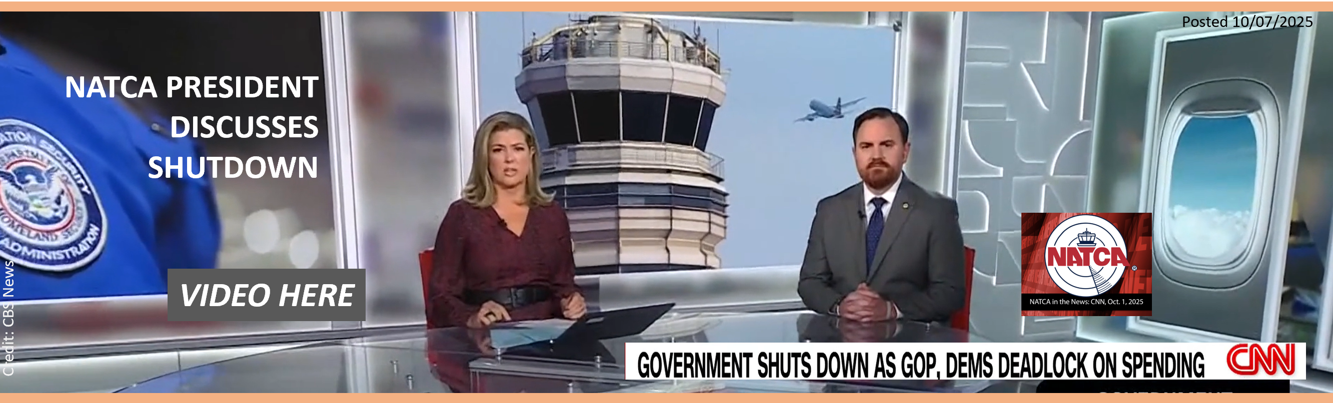
10/01/2025 NATCA in the News: President Nick Daniels Discusses Government Shutdown on CNN - From NATCA - "NATCA President Nick Daniels appeared on CNN with Brianna Keilar on Wednesday, Oct. 1, 2025, just hours after Congress failed to reach an appropriations agreement, sending the U.S. federal government into a shutdown. Daniels discussed how a shutdown is extremely stressful for air traffic controllers and other aviation safety professionals across the country, who already are dealing with critical staffing and unreliable equipment. - Daniels also talked about the approximately 2,350 NATCA members who will be furloughed during" VIDEO and Story Here.
10/04/2025 SpaceX Starship Missions Could Disrupt Florida Air Travel - From - Simple Flying -"Future airline passengers traveling through Florida may face longer delays and reroutes. The reason would not be weather or traffic, but rocket launches and landings. The Federal Aviation Administration (FAA) is currently reviewing SpaceX’s request to operate dozens of Starship-Super Heavy missions each year from NASA’s Kennedy Space Center on Florida’s east coast. - If approved, these missions could cause ground stops lasting up to two hours, affecting flights at some of the state’s busiest airports. Local airport officials and airline groups have warned that... " More to follow Here.
10/04/2025 (From Aug.21, 2025) FAA denies request to increase safety restrictions in skies above Austin's airport - From KUT NEWS - "The Federal Aviation Administration is rejecting a request to upgrade Austin's airspace to the same level surrounding the nation's busiest airports. - Class B airspace — one notch above Austin's Class C airspace — is highly regulated to reduce the risk of midair collisions. Pilots must follow stricter rules, and air traffic controllers have greater authority. - A reclassification to Class B would also have triggered an automatic 15% pay hike for air traffic controllers in the short-staffed control tower at Austin-Bergstrom International Airport. - The tower is operating with fewer than half the 60 controllers recommended in a staffing target set by..." Finish Reading Here and Gain some back story about Class B.

09/27/2025 Part 108’s Implications for Drone and GA Safety - From AVweb - "Part 108 proposals raise questions on right-of-way, portable EC devices, and pilot responsibilities'- YOUR COMMENT INVITED - OPEB UNTIL OCT. 6 -
Announced this summer under a joint FAA and TSA proposal, Part 108 could reshape low-altitude airspace by opening the door for Beyond Visual Line of Sight (BVLOS) drone operations. The rule, now in the public comment stage, marks a major departure from Part 107 and introduces questions for both the unmanned and manned communities on how aircraft will safely share skies below 400 feet. - At the core of the discussion for manned pilots: who has right-of-way, how will drones and crewed aircraft avoid each other, and can portable electronic conspicuity devices offer a bridge for aircraft without ADS-B Out." Continue Here.

09/21/2025 NASA, Partners Push Forward with Remotely Piloted Airspace Integration - From NASA - "NASA and its partners recently tested a tool for remotely piloted operations that could enable operators to transport people and goods more efficiently within urban areas. - The team’s goal is to ensure that when these remotely piloted aircraft – including electric vertical takeoff and landing vehicles (eVTOLs) – take to the skies, air traffic controllers won’t be overburdened by increased flight operations and safety is maintained across the national airspace.
On Aug. 21, NASA’s Air Traffic Management eXploration Project (ATM-X) assisted Wisk Aero when they flew a Bell 206 helicopter in Hollister, California. The purpose of the flight test was to evaluate and fine-tune a ground-based radar developed by Collins Aerospace. The radar, which provides aircraft location data, could be used during future remotely piloted operations to detect and avoid other aircraft in the vicinity. NASA, Wisk, and Collins researchers also used the flight to test data exchange capabilities across different geographic locations between the groups, a critical capability for future remotely piloted operators in a shared airspace. This work builds on a November 2024 flight test NASA performed with Reliable Robotics and Collins Aerospace." More Here.
09/21/2025 Aviation Subcommittee Chairman Troy E. Nehls and Representative Sharice Davids Release Statement on Fourth Session of the Bipartisan ATC/NAS Modernization Working Group - From NBAA - "WASHINGTON, D.C. —Today, Aviation Chairman Troy E. Nehls (R-TX-22) and Representative Sharice Davids (D-KS-03) released a statement following the fourth session of the bipartisan Air Traffic Control (ATC)/National Airspace System (NAS) Modernization Working Group: - “Today, the bipartisan Air Traffic Control (ATC)/National Airspace System (NAS) Modernization Working Group met with stakeholder groups who represent those involved in general aviation in America. From recreational flying to emergency services to non-commercial, non-scheduled civilian flight, general aviation encompasses a wide..." Finish reading Here.
09/17/2025 Pentagon plan pits U.S. Marines against California off-roaders and civilian pilots - From Military.com - "The U.S. Marine Corps tried once to occupy this remote stretch of California desert beloved by off-roaders — but officials managed eventually to broker a deal that allowed both leathernecks and dirt riders to share the same rocky canyons and wrinkled mountains of Johnson Valley.- Now, more than a decade later, the Marines are back — and this time, they want the skies. - The Pentagon has proposed restricting civilian air traffic above much of the Johnson Valley Off-Highway Vehicle Area to expand and support training exercises. But those who frequent the area just west of the Twentynine Palms Marine base say the proposal would severely limit recreational access and reduce safety.
They say the airspace restrictions could prevent rescue helicopters from evacuating injured motorists, and threaten the famed King of the Hammers off-road race that's held there each year. - And perhaps most crucially, they fear the proposal — which must be approved by the Federal Aviation Administration — is just the first step toward the Marines ending public access to an area that was set aside by Congress for public use." Very detailed Article, Read it Here.
'08/31/2025 PROPOSED NEW MOAs - IMPACT to GA - COMMENTS REQUESTED - Short Notice! *
Do You Fly Near 29 Palms R2501 and the Related MOAs?
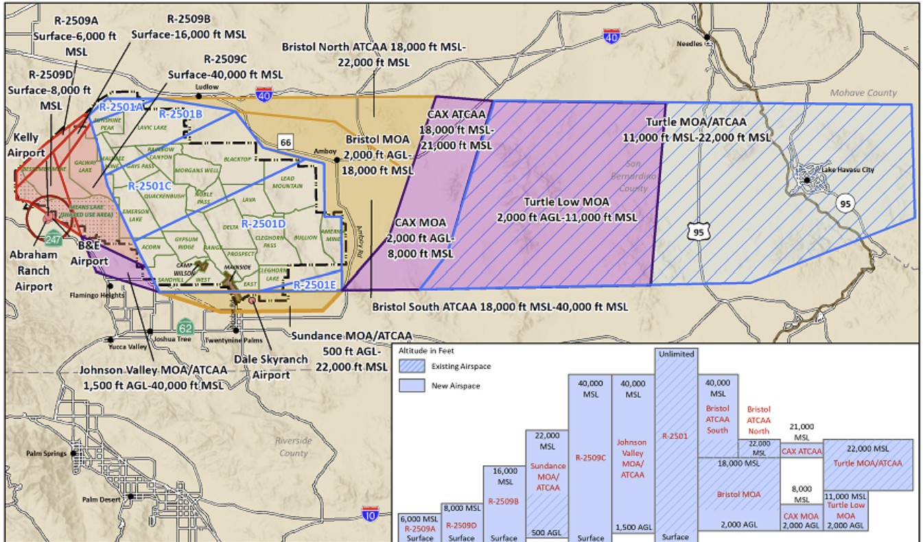
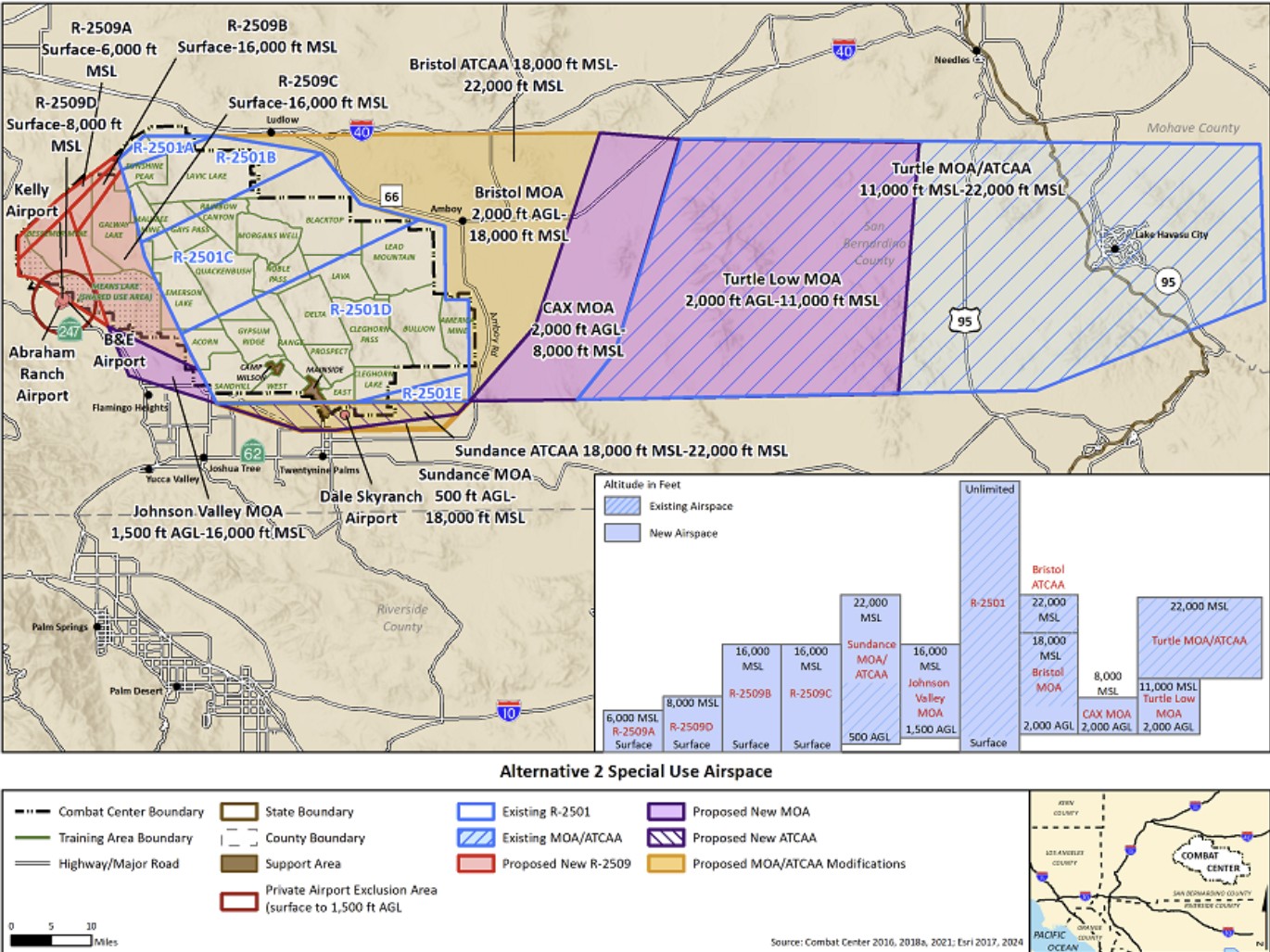
Full details of the alternatives being considered are available at this site. https://www.29palmspsua.com/Alternatives.aspx
* From Email Content sent to SCAUWG.ORG, AOPA, CalPilots, and Southern California Airspace Users Working Group.
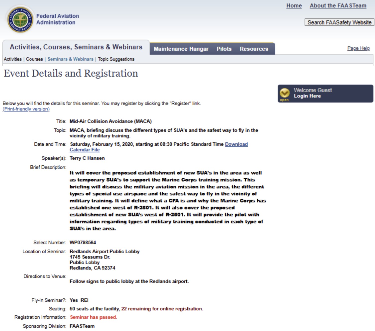
08/31/2025 The MARINE CORPS RECOGNIZED that REIs Airport Association should be kept informed YEARS AGO, But per RAA, DID NOT DO SO. See Email Below from January 21, 2020:
Date: Tue, Jan 21, 2020 at 7:53 AM
Subject: RE: [Non-DoD Source] Re: Notification Request for Public Comments Regarding the R-2501 Expansion at the MCAGCC
To: Redlands Airport Association <redlands.airport.association@gmail.com>, Terry Hansen <Terry.Hansen@cardno-gs.com>
Cc: Kosa CIV D Jonell <jonell.kosa@usmc.mil>
08/31/2025 WINGS SEMINAR Presented in 2020 (The last time the MOA project was addressed with the Redlands Airport Association:
06/29/2025 Fires erupt across Inland Empire - CBS N
08/30/2025 Decommissioning of Alaska NDB proposed - Feedback Solicited - "The FAA seeks feedback on the potential elimination of the nondirectional beacon and associated approach at Iliamna Airport in Alaska. (Google Earth image.) Continue
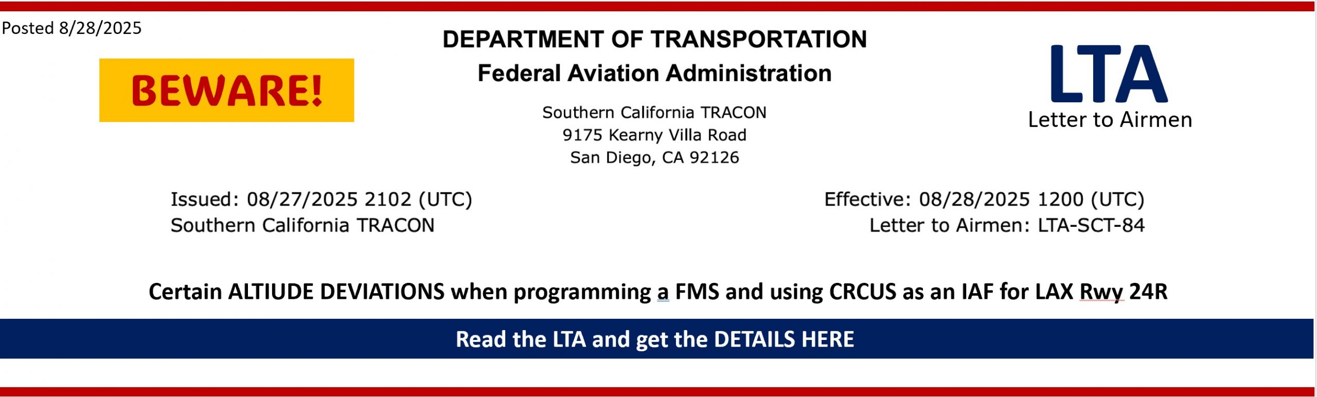
08/28/2025 Click LTA-SCT-84 IRNMN RYDRR HUULL STARs at LAX For the WARNING
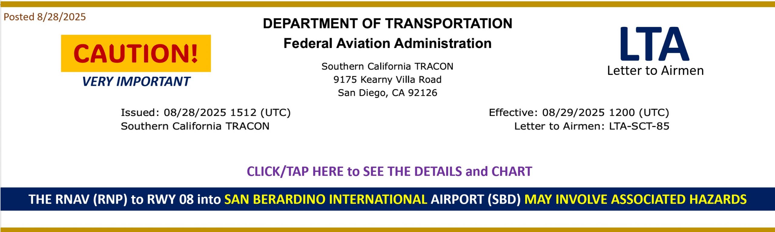
08/28/2025 Click LTA-SCT-85 SBD REI Traffic Awareness For the Cautionary Note
08/28/2025 FAA: San Bernardino International Airport Airspace and Redlands Airport Airspace
Sent: Friday, August 1, 2025 1:37:15 PM
To: Airport <Airport@cityofredlands.org>
Cc: Lopez, Daniel (FAA) <Daniel.Lopez@faa.gov>; Fuentes, Amber (FAA) <Amber.Fuentes@faa.gov>
-
- No lateral changes.
-
Ceiling increases from 3,200’ to 3,700’.
- Class E4 surface extensions (green):
- Will extend from surface (SFC) up to 700’.
- Above 700’, Riverside Class E exists outside of ONT Charlie.
- Aircraft in these E4 extensions must comply with VFR weather minimums under 14 CFR § 91.155:
- 3 NM visibility.
- 500’ below, 1,000’ above, 2,000’ horizontal from clouds.
- No requirement for aircraft in Class E extensions to communicate with SBD Tower.
- Recent 7110.65 changes do not authorize SVFR in Class E extensions.
- Class E extensions do not prohibit paragliding or glider operations in the same way as true surface Class E.
-
Class E airspace exists at all times, regardless of whether the control tower at the associated airport is open or closed.

08/28/2025 B-52 bomber almost collided with two planes: Report - From Newsweek - "A U.S. B-52 bomber nearly hit a small aircraft after avoiding an initial collision with an airliner last month, according to the National Transportation Safety Board (NTSB). - It had been previously reported that the pilot of a SkyWest commercial airliner needed to make an "aggressive maneuver" to avoid contact with a B-52 aircraft close to Minot, North Dakota, on July 19. - The B-52 was then "involved in another loss of separation event" roughly a mile away from Minot International Airport with a privately operated Piper PA-28-151 light aircraft, the NTSB said in a report published on Wednesday. The second close-call had not been previously reported." Why it Matters? Click Here.
08/27/2025 FAA Denies Austin’s Request for Class B Airspace Upgrade - From AVweb - "Agency cites traffic benchmarks as officials warn of safety risks. - The Federal Aviation Administration has denied a request to upgrade Austin-Bergstrom International Airport’s airspace from Class C to the more restricted Class B designation, despite safety concerns raised by local leaders and air traffic officials. The decision follows nearly two years of appeals from U.S. Rep. Lloyd Doggett, D-Austin, who has pressed the agency to act after a series of near collisions at the airport." More Here.
08/19/2025 Joby Completes First Piloted eVTOL Flight Between Public Airports -From AVweb - "Milestone highlights integration with FAA-controlled airspace. - Joby Aviation has flown its electric air taxi between two California airports in what the company describes as a major step toward commercial operations. The piloted eVTOL flight traveled from Marina Municipal (OAR) to Monterey Regional (MRY), marking the first time an electric vertical takeoff and landing aircraft has completed such a trip between public airports. According to Joby, the 12-minute flight included vertical takeoff, wingborne cruise, and integration into Monterey’s controlled airspace, where the aircraft sequenced with other traffic before landing." Read the full story with airspace implications Here. * Disclosure: SCAUWG.ORG Editorial Staff member does have an investment in Joby.
08/13/2025CHARTING NOTICE
To: Users of: All Aeronautical Products and Digital Services
Subject: Aeronautical Chart Users Guide – Change in Publication Schedule - The FAA will continue to publish the Aeronautical Chart Users Guide. However, beginning August 7, 2025, updates will no longer follow the regular 56-day charting schedule. Instead, revisions will be made on an as-needed basis to reflect changes or corrections.
The most current version of the Aeronautical Chart Users’ Guide can be accessed at: https://www.faa.gov/air_traffic/flight_info/aeronav/digital_products/aero_guide/
Users can submit questions or concerns online or by phone using the FAA Hotline. See: https://www.faa.gov/about/office_org/headquarters_offices/aae/programs_services/faa_hotlines
8/13/2025 CHARTING NOTICE
August 13th, 2025 To Users of: All Aeronautical Products and Digital Services, Aeronautical Information Services, AJV-A
Subject: Revised - Discontinuation of Selected Charting Products and Services Beginning August 7th, 2025
This Notice supersedes the Charting Notice published May 30, 2025. Please be advised that the FAA is discontinuing the following products:
VFR Class B Enhancement Graphics
https://www.faa.gov/air_traffic/flight_info/aeronav/digital_products/vfr_class_b/
U.S. VFR Wall Planning
https://www.faa.gov/air_traffic/flight_info/aeronav/productcatalog/planningcharts/VFRWall/
Alaska VFR Wall Planning
https://www.faa.gov/air_traffic/flight_info/aeronav/productcatalog/planningcharts/AKVFRWall/
U.S. IFR/VFR Low Altitude Planning Charts
https://www.faa.gov/air_traffic/flight_info/aeronav/productcatalog/planningcharts/US/
The final publication date for these products will be June 12, 2025. As each of the current versions of the above products expires or becomes outdated, they will be removed from the FAA website. Users can submit questions or concerns onli ne or by phone using the FAA Hotline. See:
https://www.faa.gov/about/office_org/headquarters_offices/aae/programs_services/faa_hotlines
View Aeronautical Information Services Safety Alerts and Charting Notices at (https://www.faa.gov/air_traffic/flight_info/aeronav/safety_alerts/)
for awareness of chart and data corrections. A page subscription service is available.
08/07/2025 Special to SCAUWG.ORG by Santosh Kunar - "In a recent conversation it was revealed that military helicopter pilots (especially Naval ones) always set the altimeter to match the RADAR altimeter regardless of the reported barometric altimeter setting for the area or closest field, especially because they fly over water. - This now brings in a 3rd variable re: the Helicopter Routes: barometric altitude vs. [WAAS Differential] GPS derived altitude (and now) vs. RADAR altitude.
08/07/2025 Special to SCAUWG.ORG by Santosh Kumar - "The TCAS-RA event between Southwest Airlines Boeing 737 out of Hollywood Burbank Airport (KBUR) and the ATAC Hawker Hunter tactical jet based out of NAS Point Mugu (KNTD) that conducts DACT (Dissimilar Air Combat Training) against our U.S, Navy CSGs (Carrier Strike Groups) to help train them against aerial threats in the Pacific Missile Sea Range (Restricted Area R-2519 and Warning Area W-289) off the coast of KNTD and/or W-291 southwest of us." "The ATAC Hawker Hunter pilots apparently had visual separation the entire time and there was no midair collision danger, which suggests a too sensitive or false TCAS-RA warning: TBD by the FAA and NTSB." View video by downloading this file: MOV_9942 (1)
07/30/2025 Drone ‘Hot Spots’ May Create Elevated Risk for Midair Collisions - From FLYING - "FAA-commissioned research warns that UAV flight near airports, heliports, and other busy airspace may place crewed aircraft at risk. - A recent nationwide analysis of drone activity concluded that airports, heliports, and residential neighborhoods may be “hot spots” where the risk of midair collisions between UAVs and crewed aircraft is elevated.
Researchers at Embry-Riddle Aeronautical University, Kansas State University, and Wichita State University’s National Institute for Aviation Research found that drone activity in and around congested airspace may be higher than previously thought. They also discovered that a “sizable number” of drone pilots fly above the FAA-mandated 400-foot ceiling for small uncrewed aircraft systems (UAS)—and, potentially, without authorization."
"Drone ‘Hot Spots’ - Researchers documented more than 6,000 UAS flights and analyzed 43 aerodromes. By their estimate, the drones spent about 10 percent of their total cumulative flight time operating in airspace typically used by crewed aircraft. In some locations, they believe the overlap is even greater." Full report Here.
07/15/2025 From LAX Tower Manager - re-evaluation of Helicopter Routes:
After much thought, I have reconsidered my proposal to eliminate the helicopter routes that are circled in red. And the Sepulveda Route, which is circled in yellow, already states “2500 feet or as assigned by ATC,” which maximizes safety.

A reminder to pilots to ensure that you fly at or below 150 feet on the Shoreline Route (the data below shows many helicopters at 200 feet). As we learned from the DCA accident, the altitude of the helicopter was later heavily scrutinized, so please watch that.

In April I cancelled a Letter of Agreement I had signed in 2012 with a banner tow operator. It authorized the aircraft to transition all four runways at 300 and 400 feet. My goal was to eliminate risk in the system for all users.
LAX airspace is extremely congested, and I appreciate your vigilance to keep it safe.
Sherry Avery - LAX Tower Manager
07/15/2025 From LAX Tower - proposal to revise/eliminate Helicopter Routes near LAX - (see above for re-evaluation) - This file contains a lot of information about LAX!
LAX HelIcopter Route Task Force Workbook
07/15/2025 SCAUWG.ORG CONTRIBUTING EDITOR MIKE CARSON Makes a VFR Chart Change! EMAIL RECEIVED:
From: noreply@faa.gov
Date: July 7, 2025 at 10:29:45 AM PDT
To: mike@kb6fcc.us
Subject: Aeronautical Inquiry AI-247366 has been closed
Michael Carson,
Your Aeronautical Inquiry has been closed. If you have follow-up questions or comments, please use the online inquiry form instead of sending via email.
========================================================
FAA Response:Thank you for bringing this to our attention. The current depiction is shown in blue, but you are correct, the linework for the NOAA Regulated National Marine Sanctuary Designated Areas should be shown in magenta. We will address this discrepancy and anticipate implementing this update for a future cycle.
========================================================
AI-247366
Category: Charts & Publications > VFR Charts
Chart Type: VFR Charts
Chart: Los Angeles
Inquiry: On the Los Angeles sectional chart (June 2025) the Special Conservation Areas magenta symbol is missing. For example, it is missing around the Channel Islands.
========================================================You may view your Aeronautical Inquiries online at https://nfdc.faa.gov
Aeronautical Information Portal
https://nfdc.faa.gov
07/06/2025 The FAA is alleviating the requirement for operators to seek additional FAA approval prior to using Foreign Terminal Instrument Procedures or foreign CAT II/III Facilities.
This change:
- No longer requires operators to seek approval from Safety Assurance offices for individual foreign CAT II/III runway operations or individual foreign RNP AR procedures; however, C060 and C384 will still be required to fly these procedure types, whether foreign or domestic.
- Was initiated because these procedures and facilities have reached a level of maturity that additional individual FAA review is no longer required. This change will be disseminated via the following directives issuance/revision/cancelation.
Documents include:
- Issuing FAA Notice 8900.740 to ensure the:
- Removal of Foreign Tables from OpSpec/MSpec/LOA −
- C059, Special Authorization Category I (SA CAT I) Instrument Approach and Landing Operations
- C060, Category II and Category III Instrument Approach and Landing Operations
- C384, Required Navigation Performance (RNP) Procedures with Authorization Required (AR)
- Decommissioning of OpSpec/MSpec/LOA −
- C058, Special Restrictions for Foreign Terminal Instrument Procedures
- C358, Special Restrictions for “RNP-like” Foreign RNAV Terminal Instrument Procedures with RNP Lines of Minima
- H107, Special Restrictions for Foreign Terminal Instrument Procedures
- Removal of Foreign Tables from OpSpec/MSpec/LOA −
- Revising 8900.1, Volume 3, Chapter 18, Section 5, Part C Operations Specifications—Airplane Terminal Instrument Procedures and Airport Authorizations and Limitations
- Revising Advisory Circular 120-105B, Foreign Terminal Instrument Procedures (FTIP) Acceptance/Review (Cancelling previous version: AC 120-105A)
- Cancelling FAA Order 8260.31C, Foreign Terminal Instrument Procedures (FTIP)
Please go to the following link for further explanation of these changes and to Foreign RNP AR and Foreign CAT II/III facilities spreadsheets: Foreign Terminal IFP Approvals
Note: The Foreign RNP AR and Foreign CAT II/III facilities spreadsheets are updated and will continue to be posted for 90 days to assist operators with making this transition.
Please direct any questions you have to 9-AMC-FSIFP-Oversight@faa.gov.