


From the CHART SUPPLEMENT BULLETIN 10/06/2024
SANTA PAULA (SZP)(KSZP) 1 SE UTC–8(–7DT) N34º20.82´ W119º03.70´
250 TPA—850(600) NOTAM FILE HHR
RWY 04–22: H2665X60 (ASPH) 0.3% up NE
RWY 04: Thld dsplcd 148´. Bldg. Rgt tfc.
RWY 22: Thld dsplcd 225´. Trees.
SERVICE: S4 FUEL 100LL
NOISE: Ngt operations prohibited. +4´ sign in primary sfc at NE end of arpt. 2200´ mt 1 NM S of arpt, for noise abatement
mntn 1500´ upwind over city.
AIRPORT REMARKS: Attended 1600–0100Z‡. 24 hour self fueling with all major credit cards. Be alert to wires crossing over
river bed adjacent to Rwy 04–22. Locations: 1.5 miles and 3.5 miles SW AER 04. Also, 1,500´ and 2.5 miles NE AER
22. Ultralights, banner towing, gliders, remote control models operating in the vicinity. Daily aerobatic activity 3–18 miles
E up to 5255´ AGL. No OHD apchs, no 45º entries, no crosswind entries over rwy. STAs not recommended. Enter pattern
from extended downwind leg or enter from a crosswind leg at least 1 mile byd the dep end of active rwy.
AIRPORT MANAGER: 805-933-1155
COMMUNICATIONS: CTAF 122.9
CLEARANCE DELIVERY PHONE: For CD ctc Los Angeles ARTCC at 661-575-2079.
• • • • • • • • • • • • • • • • • •
HELIPAD H1: H60X60 (ASPH)
HELIPORT REMARKS: Helicopter must use designated heliport located mid–fld on the south side. All apchs/deps are from the
south. Transient helicopter rstd to the heliport. Hover taxi not authorized.
News:
06/27/2026 - At approximately 1 p.m. today (June 27th) an aircraft was reported to have made an emergency landing in the riverbed about a quarter mile east of the runway at Santa Paula Airport. The single engine propeller Bellanca 17-30A departed Glendale, Arizona, this morning around 9 a.m. and was en route to Santa Paula Airport. The pilot was the only person on board the aircraft and was transported to a local hospital with what were reported as minor injuries and in stable condition. There was no damage to property and no other injuries reported. The Ventura County Fire Department and Ventura County Sheriff’s Office were on scene. The National Transportation Safety Board and Federal Aviation Administration were notified and will begin investigating the accident. Please respond with any questions. - Well wishes to you, Jannette O: (805) 388-4287 - E: Jannette.Jauregui@venturacounty.gov
05/24/2026 Rich Stowell’s Post


Judy Phelps Flies West
Judy Ann PHELPS, Master CFI Emeritus-Aerobatic, National CFI of the Year 2011, DPE, Owner CP Aviation, Santa Paula CA
In 2008 I relocated to Ventura, CA and soon after had the opportunity to join the team at CP Aviation. Clay and Judy were warm and welcoming and as I write this am still a member of the team. Last Fall Judy was diagnosed with Stage Four Cancer. She faced the challenge with every fiber of her being, was positive and shared her special gift with all of us. She is loved, respected and has left an indelible imprint on everyone who knew her as a friend, an instructor, a successful business owner and Designated Pilot Examiner.
Her extraordinary community of friends hosted a celebration of her life while she was still with us, and a celebration it was! It was such an amazing experience to hear the stories and be part of the love and respect that everyone shared that night at The Flying Spoon.
I have been an aviation educator at CP Aviation, for eighteen years, during which time I have been sitting in the “right seat” watching Judy manage and grow her business, along with Clay, into a very well regarded flight training organization; recognized for its’ commitment to safety and excellence and welcoming to anyone wanting to pursue a passion for flying. Her role as a Designated Pilot Examiner was something that she embraced and allowed her to have an indirect positive impact on all pilots that she had the privilege to evaluate.
Rich Stowell was a mentor for Judy as she embraced the skills required to teach and grow the Emergency Maneuver Training Program at CP Aviation. Rich posted about Judy, that expresses how special she was. “Master Flight Instructor, colleague, friend. She surpassed her mentor and showed the rest of us what it means to be an aviation educator”.
Her commitment to encouraging women, regardless of age, to pursue flying and have fun every step of the way was important to her. Hiring female instructors to make the flight school environment welcoming to women and balancing the energy in and around CP Aviation were actions that are rarely seen at other flight schools. Seeing her every year at AirVenture, volunteering her time with young women at the Girl Venture event was another example of her passion for aviation and making it welcoming and accessible to the next generation of women in aviation. Judy was a proud member of the Ventura County 99’s and they were integral to the celebration of her life.
Judy was the 2011 CFI of the Year, 2010 Western Pacific Region Flight Instructor of the Year, 2008 Professional Woman Pilot of the Year, Southwest Section (Ventura County 99’s). She is a Master Instructor Emeritus-Aerobatic having been recognized as a Master Instructor for more than 20 years. These recognitions are well deserved and recognize that since she jumped in an airplane in 1994, she has been a role model for many and will be missed. Her spirit will always live on at Santa Paula Airport.  - "Master Instructor"

Memorial Scholarship Honoring the Memory of Judy Phelps
Designated Pilot Examiner - Gold Seal Flight Instructor
Master CFII Aerobatic
“2011 National Flight Instructor of the year”
Past President of the Aviation Museum of Santa Paula
Past President of the Ventura County Chapter of the 99’s
Judy Phelps passed away on Wednesday night, May 20, 2026, surrounded by her loved ones. We know how much of an impact Judy had on every person she met. She had so many people standing by and supporting her through this journey. She appreciated it when her friends would check in with her and offer her their love and support. Judy will continue to live on through all of us. In all our memories. In the many lessons she taught us. We know many people, including her daughter Beverly, and husband Clay, will continue to hear her voice guiding us to that perfect landing or through difficult times.
In lieu of flowers or cards, Judy requested you consider donating to or volunteering for the Aviation Museum of Santa Paula. Judy was always one of the museum’s biggest advocates. She loved the museum and wanted to see it flourish.
We are proud to announce the establishment of the Judy Phelps Memorial Scholarship, created to honor Judy Phelps, DPE, and her lasting contribution to aviation training, mentorship, and excellence through CP Aviation and the Aviation Museum of Santa Paula.
This scholarship is intended to celebrate Judy Phelps's legacy by supporting aspiring aviators who demonstrate dedication, professionalism, and a passion for learning. Through this memorial scholarship, we hope to encourage the next generation of pilots to pursue their goals with the same commitment to safety, skill, and service that Judy exemplified throughout her career.
We invite students, colleagues, friends, and members of the aviation community to join us in remembering Judy Phelps by helping create opportunities for future pilots and supporting the Aviation Museum of Santa Paula.
Kevin R. Nida, President
Board of Directors
Aviation Museum of Santa Paula FOR MORE INFORMATION PLEASE VISIT: https://www.aviationmuseumofsantapaula.org/
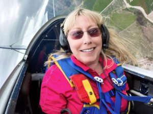
Judy Phelps
DPE, Master CFI-Aerobatic, CFI, CFII, Gold Seal AGI
Judy Phelps, Designated Pilot Examiner, Master Certified Flight Instructor-Aerobatic, CFI – Instrument, specializing in Tailwheel, Spins, Emergency Maneuver Training and Aerobatics.
Judy is our Chief Flight Instructor and a Gold Seal Advanced Ground Instructor. Her focus is on monitoring the high quality of instruction provided to our private, instrument and commercial students by conducting phase checks; as well as teaching Emergency Maneuver Training and Aerobatics.
She is the 2011 National Flight Instructor of the Year, the 2010 Western Pacific Region FAA Flight Instructor of the year, the 2008 Professional Woman Pilot of the Year by the Southwest Section of the Ninety-Nines International Organization of Women Pilots, and the 2006 Woman Pilot of the Year by the Ventura County Chapter of the Ninety-Nines. She is also a charter member of the Society of Aviation and Flight Educators (SAFE). Judy’s career in aviation started in 1994 when she met and married Clay Phelps, the CP of CP Aviation. In 2003 she became a Certified Flight Instructor (CFI) and has logged over 11,000 hours.
Judy Phelps
Normally many people assess that I have perhaps too many words. Too many details. Too many examples. This time is different. There are no amount of words that I can reference when describing the opportunities that Judy granted to so many including myself. There will be no replacement. - Ron Berinstein, Director, Southern California Aviation United Working Group.
11/10/2024 The HAZARDS TFR which included KSZP was moved south a bit, and flight at the airport was again permitted with the pattern moved to the North of the runway as opposed to the South.
The MOUNTAIN FIRE: A Major Threat!
Wednesday 11 /06/2024:
 Santa Paula Airport Ramp View
Saturday 11/09/2024:

Santa Paula Airport Runway View
11/09/2024: Mountain Fire by report (Spectrum News 1) is 17% Contained. Over 130 Structures have been destroyed. Thousands of evacuations!
11/06/2024 In a few terrifying hours, the Mountain fire exploded into SoCal's most destructive in years - From LA Times - The warnings Wednesday morning were dire: Southern Ventura County was primed to be hit with the region's most ferocious Santa Ana wind event in years, creating extremely critical fire weather in the area.
And the conditions lived up to the billing, with 60- to 80-mph gusts slamming the foothills of Moorpark and Camarillo. Alone, the winds were dangerous. But once a small fire ignited in the wilderness north of Somis, the seeds for disaster were firmly planted. Read the full account Here.
Airport Challenge:
#1) Educate Pilots using and/or transitioning through the Santa Paula Flight Intensive Training Area / Waivered Aerobatic Area that they should be reporting their position and intentions on frequency 122.775.
Flight safety demands situational awareness. No transponder is required in this area, and aerobatic activity usually does not allow for ADS-B traffic monitoring. The practice area extends East to near Magic Mountain. Both SoCal Tracon and Magu Approach cover their respective parts of the area, however, communications may not be certain because of the mountainous terrain and the aircraft's altitude. Most aerobatic aircraft only have one radio, they will be communicating on 122.775. Those aircraft with two radios are invited to monitor both ATC and 122.775.
#2) Educate visiting pilots to refer to the Chart Supplement Bulletin and include the recommended traffic pattern design and area landmarks in their preflight management.
Commentary:
Santa Paula is a very neat Airport. you'll find community support regularly visiting the airport on the first Sunday of every month. On that day and regularly, the goal is safety; the means is the superior instructional training available on the field. In addition to providing private pilot, commercial, and instrument training, conventual tailwheel and upset training are emphasized.
Superior features include two aerobatic flight training areas. The waivered airspace East of the field is the area most often in use and is supervised by CP Aviation. One can refer to the Chart Supplement Bulletin for the locations, and the dimensions and area data are available via using the Free Flight Planning application, ChartAware. ChartAware can be downloaded from SCAUWG.ORG and used as an overlay on your iPad using ForeFlight, or any application that uses KML files
The training area comes with pilot responsibility. Pilots are expected to announce their positions and intentions using the Training Area Frequency 122.775 whilst practicing in or transitioning through the area.
Santa Paula is a non-towered airport. It is not an "uncontrolled airport!" The Chart Supplement above details the rules of the sky at KSZP, and those rules might be very different than those first-time visiting pilots might expect. Pattern details are available on SCAUWG.ORG. Arriving pilots from the east when Rwy 22 is in use are expected to enter the pattern upwind over the city to the north of the airport at 1500' MSL for noise abatement. No straight-in approaches are recommended. Those pilots should extend the upwind leg until reaching Peck Road (at the city boundary where agriculture begins). Descending on the crosswind leg is expected so as to enter the downwind leg at 850' MSL. One can expect that several aircraft might turn base leg close-in whilst in the proximity of the 12th St bridge. Beware of the wires near the approach end of the runway. CTAF is 122.9 and it is expected that pilots report their positions on every pattern leg.
Okay, all of that said, I recently heard one twin-engine pilot report 10 miles east for a straight-in approach, and another reported an overhead approach. Some pilots turn a "regular" crosswind after flying over the city. The traffic pattern at Santa Paula can be a diverse mix of craft, and the pattern rules differ from regular. No 45-degree entries. One might find trikes in the pattern as well as Pitts flyers that fly fast and turn base very close-in, tailwheels that fly slow, sometimes low, and a few that fly a base very close-in and land on the grass that parallels the runway. Some helicopter activity. Safety demands listening to the radio for situational awareness and keeping one's head "on the swivel."
Transitioning through the East Practice Area. (3-18 miles east / 1500'-5500')
Many recommend flying over 126 Fwy. and using 122.775 to report position altitude and intentions. Why? Many pilots divided the area into six sections. Three north on the 126 Fwy, and three to the south of the 126 Fwy. The most popular sections are south and north of the 126 Fwy between Santa Paula and Fillmore. Flying down the center should keep you out of the fray of those who are practicing flight and/or flying aerobatic activity. Common reporting points include Grimes Canyon and Balcom Canyon. Occasional flights may be south of the mountain range at the southwest area corner opposite Grimes Canyon. PLEASE USE 122.775 and report. Your goal should not be to meet an aerobatic aircraft in the sky by accident.
Very Professional Flight Instruction and Aircraft Service can be obtained at CP Aviation. Owners Clay and Judy Phelps have an unparalleled reputation for excellence.
Santa Paula Airport Webcam: Want a picture of the airport runway, the mountain south of the field and some weather information? Just dial in the URL: www.santapaulaairport.com
The Restaurant:
The field restaurant is the Flight 126 and Hangar Bar serves a well composed menu. Servers are friendly and seating is available in the cafe for breakfast / lunch as well as on the patio facing the airport ramp. Dinner in the Hangar Bar area, and large windows provide a view of the flight activity. Space can be arranged for parties. Call for hours:(805) 525-7200 - You can visit their website at flight126.com