


![]() Announcement: Our domain has changed to airports.venturacounty.gov.
Announcement: Our domain has changed to airports.venturacounty.gov.
Please Visit Page 2 for later Posts Click Here
Special Notices: (Airport Info Follows)
2/17/2026 PUBLIC MEETING #2 March 3, 2026 6 PM
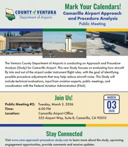
Second Public Meeting in a series
02/16/2026 ANNOUNCEMENT - The Ventura County Department of Airports is providing information related to an aircraft incident that occurred Sunday, February 15th, at approximately 6:07 p.m. A privately owned, single engine Cessna 210 reported engine trouble while enroute to Camarillo Airport (CMA). The aircraft came to rest in a concrete canal near the intersection of Carmen Drive and E. Coe Street in Camarillo. The Ventura County Fire Department and Ventura County Sheriff’s Office were the first on the scene. Two individuals were on board and were recovered from the aircraft with what were reported as significant injuries. No other injuries were associated with the incident. The aircraft, which is based at Oxnard Airport (OXR), was returning from Las Vegas with a planned landing at Camarillo Airport. The National Transportation Safety Board (NTSB) and Federal Aviation Administration (FAA) were notified and began to investigate the incident this morning. - We appreciate your time with this information. Please respond with any questions.
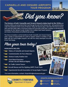
The Ventura County Department of Airports offers group tours of Camarillo and Oxnard airports. Space is limited. E-mail AirportInfo@venturacounty.gov to schedule yours today!
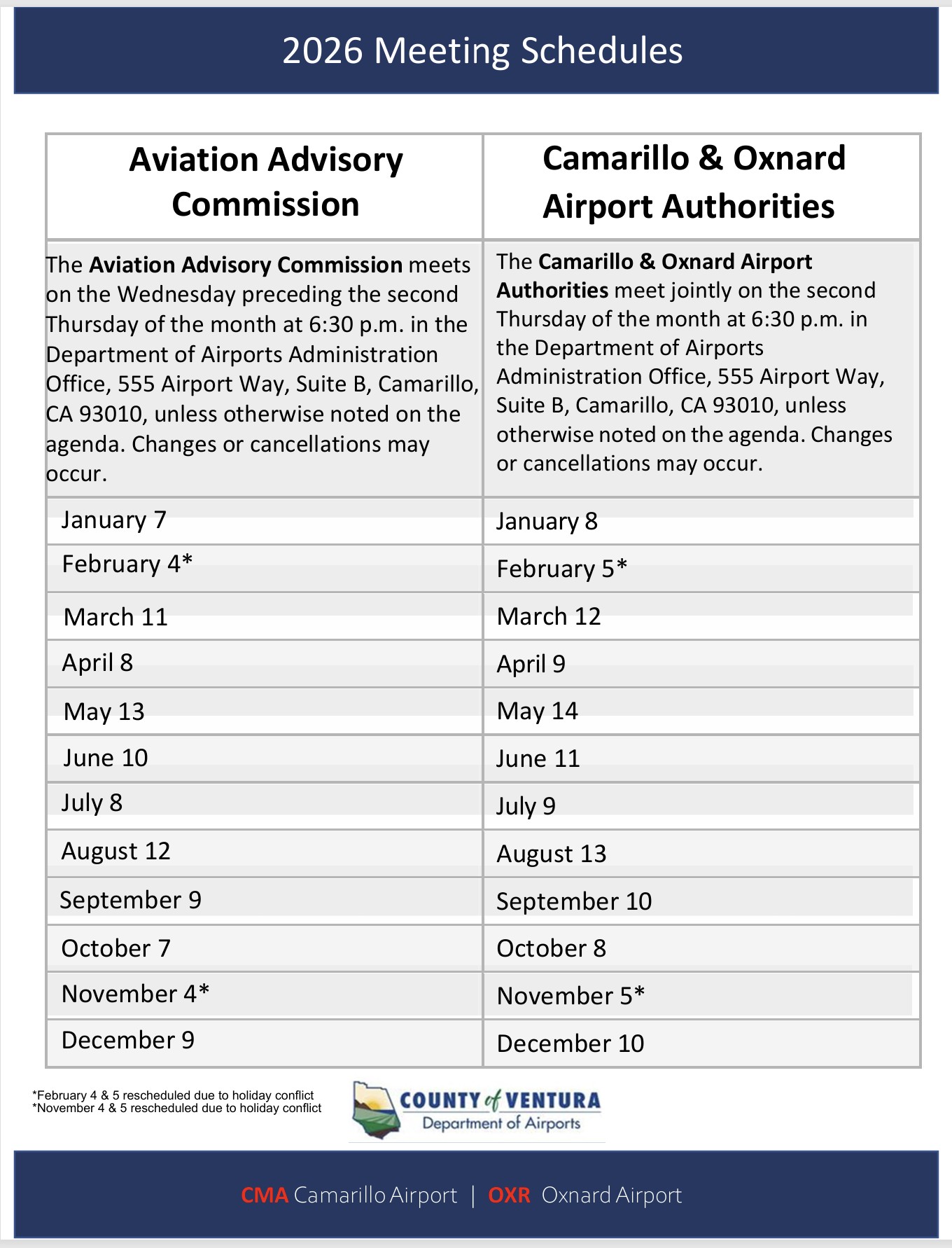
12/11/2025 Airport Advisory Commission Meeting Schedule for 2026: Note: February 4, CANCELLED - February 5, CANCELLED
.
11/03/2025 The Federal Aviation Administration (FAA) recently announced that Camarillo Airport and Oxnard Airport are among several California airports that have been awarded grant funding for infrastructural improvements. The Ventura County Board of Supervisors and County Executive Officer, Dr. Sevet Johnson, were all instrumental in securing this funding for our local airports.
“Securing this kind of funding to ensure that our facilities remain infrastructurally sound is critical,” said Keith Freitas, Director of the Ventura County Department of Airports. “Camarillo and Oxnard airports remain a vital part of Ventura County’s transportation system and provide an annual economic impact locally of nearly $300 million. We are incredibly grateful for the continued support of our elected officials and County Executive Officer and to be among the airports selected as recipients of this FAA grant award.”
During this latest round of FAA grant funding, Camarillo Airport was awarded $14.47 million to partially fund a runway rehabilitation project that will replace approximately 6,000 feet of 30-year old pavement. The start date of the Camarillo Airport runway rehabilitation project has yet to be determined. Additionally, Oxnard Airport was awarded $3.5 million, which was used to fund the pavement replacement of the main parallel taxiway.
We thank you for your time and hope you find this information helpful. Please respond with any questions or concerns. - Well wishes to you all, - Jannette
10/29/2025 The Ventura County Department of Airports remains committed to connecting with all stakeholders of both Camarillo and Oxnard Airports as we continue to provide a transparent communication system. As part of this effort, we’d like to remind the community that we have a variety of methods to connect with us, including those listed below:
Click here to be added to our Airport News e-mail list
(*scroll to the bottom of the page and fill out the form labeled “Join Our Mailing List”)
If you select this option, you will receive all “e-blast” (Airport News) communications from the Department of Airports.
Click here to be added to our Agenda Notification e-mail list
If you select this option, you will receive all agendas and meeting information for both the Aviation Advisory Commission and Airport Authorities for Camarillo and Oxnard airports.
For general inquiries about Camarillo and/or Oxnard Airports, please e-mail airportinfo@venturacounty.gov. - We hope you find this information helpful. Please respond with any questions or concerns. - Well wishes to you, Jannette
10/28/2025 For more information regarding any Ventura County Department of Airports related news, please visit Airport News – Ventura County Airports. Well wishes to you all, - Jannette
10/20/2025 The Ventura County Department of Airports announced the launch of a customer satisfaction survey in October 2024, and we continue to offer the survey to the community to help ensure that the work we are doing, and the services we provide, are meeting the expectations of all stakeholders.
Responses from this short survey will provide Airports’ staff with insights regarding all aspects of the Department including professionalism, accessibility, and communications. Your responses will help us better understand our strengths as well as areas in which we are not meeting expectations as we continue to strive to serve all who have a vested interest in both Camarillo and Oxnard airports.
This survey should take only a few minutes to complete. Whether you are a business partner, community member, customer, pilot, or tenant, your voice matters. We thank you for your time and commitment to helping us ensure you have a positive experience with the Ventura County Department of Airports.
Click here to take the online survey.
You can also find the survey on the homepage of our website (vcairports.org). Those interested in completing a paper survey may visit our office located at 555 Airport Way, Suite B, in Camarillo. - Well wishes to you all, - Jannette
10/16/2025 Thank you to all who joined us at the first public meeting for the Approach and Procedure Analysis (Study) for Camarillo Airport. At the meeting, the project team shared an overview of the Study and presented three new flight procedure adjustments under consideration that may help reduce aircraft noise. We appreciated the opportunity to answer questions and listen to your valuable feedback.
For those who were unable to attend, the presentation and recording are available through the links below and on the Study website.
Next Steps
The project team will continue refining the proposed flight procedures adjustments based on community and stakeholder feedback. Additional potential procedures will also be developed for further consideration. The next public meeting is anticipated to be held in early 2026.
Stay Connected
To learn more about the Study, please visit https://www.cma-approach-procedure-study.com/.
Well wishes to you all,
Jannette, County of Ventura, Dept of Airports - Communications & Engagement Manager & Public Information Officer, O: (805) 388-4287 E: Jannette.Jauregui@venturacounty.gov


EXCERPT From Chart Supplement Bulletin SW, 12 JUN 2025 to 7 AUG 2025 (Above)


EXCERPT From Chart Bulletin Supplement SW, 12 JUN 2025 to 7 AUG 2025 (Above)

EXCERPT From POINT MUGU NAS (NAVAL BASE VENTURA CO) (NTD)(KNTD) NAS (ANG) Chart Supplement Bulletin SW, 12 JUN 2025 to 7 AUG 2025

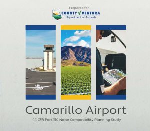
Introduction to Camarillo Airport


For these procedures, please refer to the Ventura County Airport Website Click Here
Ventura County News, Events, Challenges & Reference Material
02/12/2026 What initiated Camarillo’s Requests for Proposals (RFPs)?
CMA Site One Development Here
CMA Site Two Development Here
The Ventura County Department of Airports would like to provide regular updates regarding the Requests for Proposal (RFP) related to Camarillo Airport, specifically with regard to the development and/or repair or replacement of existing hangars. We’d like to provide clarification regarding these RFPs and what the possible projects will mean for Camarillo Airport and for the community. As a reference, we have attached both open RFPs.
- What initiated the Requests for Proposals (RFPs)?
We received several letters of interest for the sites from current tenants at Camarillo Airport, which led to the RFPs. As we shared during the Part 150 Noise Compatibility Study process, the FAA requires that we consider and evaluate proposals for additional development. Should a proposal be accepted, the goal would be to protect the integrity of the structures at the airport through either the development of new hangars OR the replacement/repair of current hangars that are in disrepair.
So why even consider the development of new and/or larger hangars?
As we have shared, both Camarillo and Oxnard airports are federally funded, which means we are required to consider all development proposals, which precludes us from excluding certain types of aviation development.
Having said that, it is important to note that both open RFPs reference the following requirements of any potential developer, with mindfulness of the community set as the highest priority:
The desired improvement/development proposal shall include aviation facilities beneficial to and compatible with the community, airport users, and customers, and consistent with the existing Airport Master Plan and recent Airport Layout Plan Update, as further described below.
Why are the bids unavailable on the Department of Airports website? Continue to read this document HERE.
01/04/2026 VENTURA CTY PILOTS INCLUDED - Agency shake-up for Southern California firefighting aircraft program - From NBC News - "The helicopters could be deployed at a moment’s notice, primarily in a six-county region of Southern California but would be available as needed to fight fires in any of the 15 counties where Southern California Edison (SCE) provides electric utility services, providing aircraft support in areas where tanker planes might not always play a role, particularly at night when those planes are usually grounded." - “The QRF has proven to be a game-changing resource in reducing wildfire risk in Southern California,” a statement from SCE read. - The program established by now-former Orange County Fire Authority (OCFA) Chief Brian Fennessy in 2021 expired last Wednesday and will not be renewed as originally designed after members of the OCFA board failed to vote to approve a new contract." The Entire Story Here.
The Ventura County Department of Airports offers group tours of Camarillo and Oxnard airports. Space is limited. E-mail AirportInfo@venturacounty.gov to schedule yours today!
12/11/2025 Airport Advisory Commission Meeting Schedule for 2026: Note: February 4, CANCELLED - February 5, CANCELLED
.
11/03/2025 The Federal Aviation Administration (FAA) recently announced that Camarillo Airport and Oxnard Airport are among several California airports that have been awarded grant funding for infrastructural improvements. The Ventura County Board of Supervisors and County Executive Officer, Dr. Sevet Johnson, were all instrumental in securing this funding for our local airports.
“Securing this kind of funding to ensure that our facilities remain infrastructurally sound is critical,” said Keith Freitas, Director of the Ventura County Department of Airports. “Camarillo and Oxnard airports remain a vital part of Ventura County’s transportation system and provide an annual economic impact locally of nearly $300 million. We are incredibly grateful for the continued support of our elected officials and County Executive Officer and to be among the airports selected as recipients of this FAA grant award.”
During this latest round of FAA grant funding, Camarillo Airport was awarded $14.47 million to partially fund a runway rehabilitation project that will replace approximately 6,000 feet of 30-year old pavement. The start date of the Camarillo Airport runway rehabilitation project has yet to be determined. Additionally, Oxnard Airport was awarded $3.5 million, which was used to fund the pavement replacement of the main parallel taxiway.
We thank you for your time and hope you find this information helpful. Please respond with any questions or concerns. - Well wishes to you all, - Jannette
10/29/2025 The Ventura County Department of Airports remains committed to connecting with all stakeholders of both Camarillo and Oxnard Airports as we continue to provide a transparent communication system. As part of this effort, we’d like to remind the community that we have a variety of methods to connect with us, including those listed below:
Click here to be added to our Airport News e-mail list
(*scroll to the bottom of the page and fill out the form labeled “Join Our Mailing List”)
If you select this option, you will receive all “e-blast” (Airport News) communications from the Department of Airports.
Click here to be added to our Agenda Notification e-mail list
If you select this option, you will receive all agendas and meeting information for both the Aviation Advisory Commission and Airport Authorities for Camarillo and Oxnard airports.
For general inquiries about Camarillo and/or Oxnard Airports, please e-mail airportinfo@venturacounty.gov. - We hope you find this information helpful. Please respond with any questions or concerns. - Well wishes to you, Jannette
10/28/2025 For more information regarding any Ventura County Department of Airports related news, please visit Airport News – Ventura County Airports. Well wishes to you all, - Jannette
10/20/2025 The Ventura County Department of Airports announced the launch of a customer satisfaction survey in October 2024, and we continue to offer the survey to the community to help ensure that the work we are doing, and the services we provide, are meeting the expectations of all stakeholders.
Responses from this short survey will provide Airports’ staff with insights regarding all aspects of the Department including professionalism, accessibility, and communications. Your responses will help us better understand our strengths as well as areas in which we are not meeting expectations as we continue to strive to serve all who have a vested interest in both Camarillo and Oxnard airports.
This survey should take only a few minutes to complete. Whether you are a business partner, community member, customer, pilot, or tenant, your voice matters. We thank you for your time and commitment to helping us ensure you have a positive experience with the Ventura County Department of Airports.
Click here to take the online survey.
You can also find the survey on the homepage of our website (vcairports.org). Those interested in completing a paper survey may visit our office located at 555 Airport Way, Suite B, in Camarillo. - Well wishes to you all, - Jannette
10/16/2025 Thank you to all who joined us at the first public meeting for the Approach and Procedure Analysis (Study) for Camarillo Airport. At the meeting, the project team shared an overview of the Study and presented three new flight procedure adjustments under consideration that may help reduce aircraft noise. We appreciated the opportunity to answer questions and listen to your valuable feedback.
For those who were unable to attend, the presentation and recording are available through the links below and on the Study website.
Next Steps
The project team will continue refining the proposed flight procedures adjustments based on community and stakeholder feedback. Additional potential procedures will also be developed for further consideration. The next public meeting is anticipated to be held in early 2026.
Stay Connected
To learn more about the Study, please visit https://www.cma-approach-procedure-study.com/.
Well wishes to you all,
Jannette, County of Ventura, Dept of Airports - Communications & Engagement Manager & Public Information Officer, O: (805) 388-4287 E: Jannette.Jauregui@venturacounty.gov
EXCERPT From Chart Supplement Bulletin SW, 12 JUN 2025 to 7 AUG 2025 (Above)
EXCERPT From Chart Bulletin Supplement SW, 12 JUN 2025 to 7 AUG 2025 (Above)
EXCERPT From POINT MUGU NAS (NAVAL BASE VENTURA CO) (NTD)(KNTD) NAS (ANG) Chart Supplement Bulletin SW, 12 JUN 2025 to 7 AUG 2025
Introduction to Camarillo Airport
For these procedures, please refer to the Ventura County Airport Website Click Here
Ventura County News, Events, Challenges & Reference Material
02/12/2026 What initiated Camarillo’s Requests for Proposals (RFPs)?
CMA Site One Development Here
CMA Site Two Development Here
The Ventura County Department of Airports would like to provide regular updates regarding the Requests for Proposal (RFP) related to Camarillo Airport, specifically with regard to the development and/or repair or replacement of existing hangars. We’d like to provide clarification regarding these RFPs and what the possible projects will mean for Camarillo Airport and for the community. As a reference, we have attached both open RFPs.
- What initiated the Requests for Proposals (RFPs)?
We received several letters of interest for the sites from current tenants at Camarillo Airport, which led to the RFPs. As we shared during the Part 150 Noise Compatibility Study process, the FAA requires that we consider and evaluate proposals for additional development. Should a proposal be accepted, the goal would be to protect the integrity of the structures at the airport through either the development of new hangars OR the replacement/repair of current hangars that are in disrepair.
So why even consider the development of new and/or larger hangars?
As we have shared, both Camarillo and Oxnard airports are federally funded, which means we are required to consider all development proposals, which precludes us from excluding certain types of aviation development.
Having said that, it is important to note that both open RFPs reference the following requirements of any potential developer, with mindfulness of the community set as the highest priority:
The desired improvement/development proposal shall include aviation facilities beneficial to and compatible with the community, airport users, and customers, and consistent with the existing Airport Master Plan and recent Airport Layout Plan Update, as further described below.
Why are the bids unavailable on the Department of Airports website? Continue to read this document HERE.
01/04/2026 VENTURA CTY PILOTS INCLUDED - Agency shake-up for Southern California firefighting aircraft program - From NBC News - "The helicopters could be deployed at a moment’s notice, primarily in a six-county region of Southern California but would be available as needed to fight fires in any of the 15 counties where Southern California Edison (SCE) provides electric utility services, providing aircraft support in areas where tanker planes might not always play a role, particularly at night when those planes are usually grounded." - “The QRF has proven to be a game-changing resource in reducing wildfire risk in Southern California,” a statement from SCE read. - The program established by now-former Orange County Fire Authority (OCFA) Chief Brian Fennessy in 2021 expired last Wednesday and will not be renewed as originally designed after members of the OCFA board failed to vote to approve a new contract." The Entire Story Here.
10/05/2025 FAA awards Camarillo Airport $14.4 million for runway repairs - From VC Star Sept. 23, 2025 - "Funding from the Federal Aviation Administration will allow for much needed repairs at the Camarillo Airport. - The facility will use a $14.4 million grant from the FAA's Airport Improvement Program, announced Sept. 19, to repave its runway, which is more than three decades old. The funding, one of the largest sums the Camarillo Airport has received, is part of a combined $170 million awarded to 46 airports across California.- “As you can imagine, in airports the No. 1 critical thing to have is an operational runway,” said Keith Freitas, Ventura County director of airports." - "Repairs are expected to take place in early 2027, and Freitas said work will be completed at night so the businesses located at 555 Airport Way do not need to close during the day." - Full Story Here
(Cancelled) 09/22.-29 The Commemorative Air Force Museum Southern California Wing, which is based at Camarillo Airport, will be welcoming the B-17 Sentimental Journey tour the week of September 22nd. The tour is scheduled to end Monday, September 29th. - Residents can expect to see the Douglas B-17 Flying Fortress operational in the Ventura County area during its visit. One of only three B-17s in the world that are still flying, the aircraft can be expected to be seen flying lower and slower than what residents may see from other aircraft, which is typical for a B-17. The aircraft’s unique engine will also produce a different sound than what residents may typically hear. - The Sentimental Journey tour is offering both ground tours and flights beginning Wednesday. [Event%20Archives%20-%20CAF%20SoCal]Click here to learn more. - Please respond with any questions or concerns. - Well wishes to you all, - Jannette
08/14/2025
08/14/2025 From: Jannette Jauregui, MSJ - Communications & Engagement Manager & Public Information Officer -Jannette.Jauregui@venturacounty.gov
As a follow-up to our prior communication updates regarding airport noise studies, last week the Ventura County Department of Airports held public hearings on the FAR Part 150 Noise Compatibility Programs for both Camarillo and Oxnard Airport noise studies. We also provided to each audience a presentation that summarized project accomplishments and staff answered all questions both before and after the formal hearing. The meetings were recorded so that anyone unable to attend the meetings would have access to all information shared during the meetings.
Accordingly, the Ventura County Department of Airports is pleased to share video links to last week’s community meetings for both Camarillo and Oxnard Airports. Separate links are provided below for each meeting section. Part 1 covers the first hour, which included a summary presentation and questions from the audience that were answered by the panel. Part 2 is the formal hearing where the Noise Compatibility Program measures are identified, followed by audience comments that will be answered in writing by the project team and included in the study documents. Part 3 captures all remaining questions and comments made immediately following the formal hearing.
CAMARILLO AIRPORT
[Camarillo%20Airport%20Part%201%20–%20Presentation%20and%20Q&A]Camarillo Airport Part 1 – Presentation and Q&A (https://youtu.be/yBq6XqXW0DI)
[Camarillo%20Airport%20Part%202%20-%20Formal%20Hearing]Camarillo Airport Part 2 - Formal Hearing (https://youtu.be/MzbgNPJSXG8)
[Camarillo%20Airport%20Part%203%20-%20Q&A%20Resumes]Camarillo Airport Part 3 - Q&A Resumes (https://youtu.be/ixLC4ydiKwg)
OXNARD AIRPORT
[Oxnard%20Airport%20Part%201%20-Presentation%20and%20Q&A]Oxnard Airport Part 1 -Presentation and Q&A (https://youtu.be/Exp_EcnQOJ0)
[Oxnard%20Airport%20Part%202%20-%20Formal%20Hearing]Oxnard Airport Part 2 - Formal Hearing (https://youtu.be/6OZV626jZDA)
[Oxnard%20Airport%20Part%203 -%20Q&A%20Resumes]Oxnard Airport Part 3 - Q&A Resumes (https://youtu.be/FBORQaapTe8)
As a reminder, the public comment process for both studies remainS open through August 19th.
Click here to visit our website and access all study documents and/or provide a public comment.
We appreciate your time very much. Please respond with any questions or concerns.
Well wishes, Jannette
8/9/2025
This message is a follow-up e-mail regarding our noise comment phone line being down as part of an outage affecting several parts of the County. The noise comment line is now up and running. We appreciate your patience during this time. Below are some important points to note:
VNOMS remains the best way to log a noise comment/disturbance. Click here to leave a noise comment using VNOMS.
If you’d like your noise comment logged into the system for further research and as part of our noise data, please use VNOMS or the noise comment phone line only.
The correct noise comment phone number is 805-382-3022. This number should be utilized only for comments not logged using VNOMS. You may leave a single message to note all noise disturbances in a single day.
We’d like to emphasize that Airports’ staff will still be available for calls and/or e-mails related to noise concerns that do not need to be logged or included in our noise comment data. Our commitment to the community and all Airports stakeholders will remain a priority always.
We appreciate your time. Please respond with any questions or concerns. - Well wishes, Jannette
8/8/2025 From: Jauregui, Jannette<Jannette.Jauregui@venturacounty.gov>
As you may know, the Canyon Fire broke out in the mountains near Piru north of Highway 126 early yesterday (8/7) afternoon. The fire quickly spread to the east and into Los Angeles County. Fire crews from throughout the region immediately mobilized to attack the blaze, including resources from the Ventura County Air Unit.
Neighbors may notice an increase in air traffic due to the fire response, with a particular increase in helicopter activity. Additionally, Los Angeles County Fire is expected to send firefighting helicopters and support equipment to Camarillo and Oxnard airports as part of the Canyon Fire response.
It is important to note that Ventura County Fire and the Ventura County Aviation Unit are currently providing support for both the Canyon Fire and Gifford Fire, which has been burning in the Santa Barbara and San Luis Obispo area since August 1st.
The Department of Airports would like to once again send our gratitude to our emergency response teams for the continued partnerships in providing critical, lifesaving resources to the community.
Please response with any questions or concerns. - Jannette
Below is information related to this weekend’s Wings Over Camarillo air show. We are resending the information sent last week with an added update regarding the FA-18 departure.
As a reminder, the Wings Over Camarillo air show is coming to Camarillo Airport this weekend. the Department of Airports would like to inform the community of what to expect in the days leading up to the event, during the event, and at the closing of the event.
Aircraft will be arriving for the air show beginning this afternoon (8/14), including two FA-18s, both of which are expected to arrive at approximately 4 p.m. today. It is important to note that the FA-18s will not be performing in the air show but will be on static display for visitors to see up close. Aircraft coming Friday (8/15) are expected to arrive between 11 a.m. and 6 p.m.
Neighbors can expect an increase in air traffic and noise for the entirety of the airshow on Saturday, August 16th and Sunday, August 17th, primarily between 12 p.m. and 5 p.m. Some aircraft will depart the area on Sunday, August 17th between 5 p.m. and 6 p.m. One FA-18 will be departing at approximately 2 p.m. Sunday, while the other, larger aircraft, including the second FA-18, are expected to depart on Monday before noon.
The Department of Airports and the Camarillo Wings Association are working closely alongside Ventura County Animal Services to ensure that our neighbors are aware of expected noise impacts, including those on animals in the area. All pyrotechnics associated with the air show are ground based and will be conducted with animals at the shelter in mind.
About the 2025 Wings Over Camarillo Air Show
This year’s event will provide visitors with the opportunity to experience all things aviation including multiple aerobatic performances, a mini jet show, two eVTOL (electric vertical take-off and landing) aircraft performances, sail plane, E-2 Hawkeye, Dawn Patrol, a B-25, Japanese Zero, and the C-53 D-Day Doll (which isn’t just named for, but was actually used in, the 1944 landing on the shores of France), STEM pavilion, car show, community vendors, and more.
We hope you find this information helpful. Please respond to this e-mail with any questions or concerns.
|
555 Airport Way, Suite B Camarillo, CA 93010 |
Jannette Jauregui, MSJ Communications & Engagement Manager & Public Information Officer O: (805) 388-4287 E: Jannette.Jauregui@venturacounty.gov airports.venturacounty.gov
Please note my email address has recently changed as has our website URL. Please update your records accordingly. |
|


PART 150 NOISE STUFY DATES
07/01/2025 The Ventura County Department of Airports is in the process of updating the Part 150 Noise Compatibility Study for the Camarillo Airport (CMA) in accordance with Title 14 of the Code of Federal Regulations, Part 150 (14 CFR Part 150). This study is a cooperative effort between the Ventura County Department of Airports and the Federal Aviation Administration (FAA). This voluntary Part 150 study, which is funded by a grant from the FAA, will update the Noise Exposure Maps for Camarillo Airport published in 1998 and Part 150 Study Noise Compatibility Program adopted in 1999.
It is important to understand what this study does and does not do.
A Part 150 Study:
- Identifies the current and projected annualized aircraft noise levels at Camarillo Airport using the Community Noise Equivalent Level (CNEL) noise metric.
- Identifies measures to reduce the noise impacts within the noise exposure contours from aircraft operating to and from Airport through changes in aircraft operations or airport facilities.
- Encourages future land uses which are compatible with aircraft noise, such as commercial or industrial in undeveloped areas.
- Determines methods to reduce the adverse impacts of noise above FAA thresholds in existing residential areas.
- Establishes a procedure to implement, review, and update the program.
A Part 150 Study does not:
- Evaluate aircraft operations from other area airports.
- Consider other types of impacts (air quality, accidents, etc.).
- Use noise metrics other than CNEL to determine noise impacts.
- Provide justification for airport expansion.
This website hosts project-related materials for review on the Documents page.
Click here for a PDF of the Initiation Brochure that provides more details about the study.
You can WATCH a CMA NOISE WORKSHOP VIDEO by CLICKING HERE
April 2023 - Camarillo Airport ALP Update And Narrative Report - "The Department of Airports is conducting an Airport Layout Plan & Narrative Report study (ALP Update) for Camarillo Airport (CMA) with the clear objective to provide systematic guidelines for the Airport’s overall maintenance, development, and operation. In contrast with an Airport Master Plan, the study will not include an analysis to examine whether CMA’s role could change over time. The ALP Update is concerned only with identifying strategies that will sustain the airport within the same role CMA has had since its inception as a General Aviation Airport in 1976.
The ALP Update is a proactive document which identifies and plans for future facility needs well in advance of the actual need for the facilities. This is done to ensure that Airport management can coordinate project approvals, design, financing, and construction to avoid experiencing detrimental effects due to inadequate facilities.
The study will be prepared by Coffman Associates, a national aviation consulting firm specializing in airport planning studies. The study process is anticipated to take approximately 18 months to complete, followed by agency reviews and approvals. The structure of the ALP Update follows FAA guidelines. Accordingly, the FAA will also review and approve the aviation forecasts as well as the technical drawings depicting the current and planned layout of all facilities, which is a minimum requirement to establish eligibility for FAA grant funding.
For a PDF of the Initiation Handout that provides more details about the study, click here.
STUDY DOCUMENTS
Click here for a PDF of the Initiation Brochure that provides more details about the study.
 Download .pdf Download. pdf Download .pdf
Appendix A: Planning Advisory Committee
Appendix B: Public Participation
Appendix C: Joint Powers Agreement
Appendix D: Grant Assurances
Appendix E: NCP Review
Sky Diving in Camarillo
July 11, 2022 Ventura County to announce plans to ditch Camarillo Airport Master Plan update - From VC Star - "Ventura County Department of Airports is abandoning its Camarillo Airport Master Plan update in response to community opposition. Airports Director Keith Freitas will present plans to transition away from a master plan and instead update the airport layout plan at the Wednesday Camarillo City Council meeting. The master plan explores future possibilities for the airport while the layout plan focuses on maintenance and other near-term projects, he said. Freitas said Monday the decision to do away with the update was due to negative feedback from the city and residents. While updating the master plan last year, the county began the process to amend a 1976 agreement with Camarillo. Read the story Here.

The Ventura County Department of Airports recently added new Fly Friendly VC signage at Oxnard Airport. The signs, which are part of the pilot education element of Fly Friendly VC, replace outdated signage that was located at gates V4 and V5 off of 5th Street. A third sign was added for the gate off of Victoria Avenue to help ensure that Fly Friendly VC is accessible to as many pilots as possible.

The Department of Airports remains committed to Fly Friendly VC and to seeking ways to continue to educate both pilots and the neighboring communities about the program.
We hope you find this information helpful. Please respond with any questions or concerns. - Jannette O: (805) 388-4287 E: Jannette.Jauregui@venturacounty.gov

Updates to Oxnard Pilot Guide for Fly Friendly VC
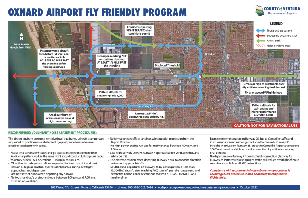


6 Training Flights over Oxnard


Additional Flight Tracks: See Website HERE

News, Events, Challenges & Reference Material
OXNARD AIRPORT PART 150 STUDY
PART 150 NOISE STUFY DATES
The Ventura County Department of Airports is in the process of preparing a Part 150 Noise Compatibility Study for the Oxnard Airport (OXR) in accordance with Title 14 of the Code of Federal Regulations, Part 150 (14 CFR Part 150). This study is a cooperative effort between the Ventura County Department of Airports and the Federal Aviation Administration (FAA). This voluntary Part 150 study, which is funded by a grant from the FAA, will include Noise Exposure Maps and a Part 150 Noise Compatibility Program for Oxnard Airport.
It is important to understand what this study does and does not do.
A Part 150 Study:
- Identifies the current and projected annualized aircraft noise levels at Oxnard Airport using the Community Noise Equivalent Level (CNEL) noise metric.
- Identifies measures to reduce the noise impacts within the noise exposure contours from aircraft operating to and from Airport through changes in aircraft operations or airport facilities.
- Encourages future land uses which are compatible with aircraft noise, such as commercial or industrial in undeveloped areas.
- Determines methods to reduce the adverse impacts of noise above FAA thresholds in existing residential areas.
- Establishes a procedure to implement, review, and update the program.
A Part 150 Study does not:
- Evaluate aircraft operations from other area airports.
- Consider other types of impacts (air quality, accidents, etc.).
- Use noise metrics other than CNEL to determine noise impacts.
- Provide justification for airport expansion.
This website hosts project-related materials for review on the Documents page.
Click here for a PDF of the Initiation Brochure that provides more details about the study.
SKYDIVING OPERATIONS AT OXNARD AIRPORT (KOXR)
Effective Dates: Ongoing
Primary Contact: Keith Freitas, Director of Airports, Ventura County, (805) 388-4200
Skydiving Operator: Skydive Coastal California,(805) 222-4763
Overview:
Skydiving operations are being conducted at and in the vicinity of Oxnard Airport (KOXR) on a daily
basis, weather permitting, from 9:00 AM to sunset, except Tuesdays and Wednesdays. Pilots
operating in or near KOXR are advised to exercise caution and maintain vigilant situational
awareness due to frequent parachute activity.
Operational Details:
Jump Details: Tandem jumps only, maximum two sky divers per drop
Drop Zone Location: On the southwest corner of the airfield.
Jump Altitude: 8,000 feet MSL
Drop Aircraft: Cessna 182
Communications:
CTAF (KOXR): 134.95 MHz
Mugu Approach: 124.7 or 128.65 MHz
Expected Activity Hours: Thursday through Monday, sunrise to sunset
Parachute Descent Area: Surface to 8,000’ MSL within a 2–3 NM radius of drop zone center.
Pilot Advisory:
Check KOXR NOTAMS for any current details.
Monitor KOXR ATIS 118.05 whether skydiving operations are in effect
Contact CTAF (134.95) in the Class D or Mugu Approach (124.7) in the general vicinity of KOXR
above 2,000 MSL when skydiving operations are in effect. Jump plane will normally announce
“jumpers away in two minutes” on these frequencies. KOXR will advise pilots in Class D airspace
that skydiving operations have commenced, landing on the south side of the runway.
Maintain the runway centerline while departing during skydiving operations. Avoid overflying
the published drop zone during active jump operations
Be prepared! Pilots have been easily startled when departing runway 25 or landing runway 7
due to proximity of the drop zone with normal flight paths. At altitude, be prepared that
parachutists may be encountered from 8,000 feet MSL to surface level within five miles to the
south of the airport.
Report any conflicts or hazards to the Ventura County Director of Airports or FAA VNYS FSDO.


Jump Plane stays usually within 6 miles of OXR

Jump Plane Flight Path
RESOURCES

FAA Airport Compliance OXR Voluntary Noise Abatement Flight School Directory
 What is Avgas? Flight Training Video Contact Us
Sky Diving in Oxnard