


“Supporting Airports, Strengthening Communities”
This Page starts with April 1, 2026 - For Prior Events See Page 2
Updates & Proposed Changes
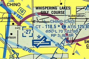
CLASS C CONFLICT with CHINO Traffic Pattern
The Los Angeles Terminal Area Chart (TAC) is updated every 56 days.
How to REPORT CHART ISSUES: "Aeronautical Inquiries"
Use this link: http://www.faa.gov/air_traffic/flight_info/aeronav/aero_data/aeronautical_inquiries
VFR CHART CHANGE NOTICES:
The Western Service Center Operations Support Group provided the attached “CHARTING NOTICE – 56-Day Visual Charts” from the FAA web site; https://www.faa.gov/air_traffic/flight_info/aeronav/safety_alerts/
The notice states; "Like other FAA Supplement, Enroute and Terminal products, each new visual navigation chart title panel will indicate the applicable AIRAC effective date range and no longer include an edition number.”
As the IFR charts on 56-day publishing schedule do not have an edition number, the new 56-day visual charts will be identified in the same way using effective dates.
Aeronautical Charting Meeting (Charting Group)
- The Aeronautical Charting Meeting (ACM) is a public meeting held two times every year. The purpose of the ACM is three-fold:
- Identify issues concerning safety and usefulness of aeronautical charts and flight information products/services.
- Discuss and evaluate proposals concerning aeronautical charts and flight information publications, digital aeronautical products, database coding, instrument flight procedures, and instrument flight procedure development, policy, and design.
- Provide an opportunity for government and interested participants to brief and/or discuss new navigation concepts, terminal instrument procedures (TERPS) policy/criteria changes, and charting specifications and methodologies.
The Aeronautical Charting Meeting is divided into two groups — the Instrument Procedures Group (IPG) and the Charting Group (CG) See Order 7910.5.
The CG portion of the ACM includes briefings and discussions on recommendations regarding aeronautical charts and flight information products/services. Please visit the ACM Instrument Procedures Group Web Site for information regarding Instrument Procedure issues.
The meeting is a facilitated discussion of new and outstanding topics. The status of an open issue will be reported from meeting to meeting until a resolution is reached, at which point the issue will be closed.
Last Meeting was held on April 20-23, 2026
06/09/2026 Aeronautical Charting Meeting for U.S. Federal Aviation Administration: information has recently been updated and is now available.
- Regarding the Aeronautical Charting Meeting for U.S. Federal Aviation Administration. This information has recently been updated, and is now available.
- ACM 26-01 CG Minutes, April 20-23, 2026 (PDF)
- The next meeting will be held virtually September 21-23, 2026.
- New submission deadline for ACM 26-02 August 21, 2026
- The minutes for the Instrument Procedures Group Portion of ACM 26-01 are available on the IPG Website.
Rune Duke
Aviation Safety Flight Technologies & Procedure Division, Flight Procedures & Airspace Group
Flight Technologies & Procedures Division webpage
Jennifer L. Hendi
Aeronautical Information Services, AJV-A2
Visit Aeronautical Information Services Here
FLIGHT in the INLAND EMPIRE - PRECAUTION!
Pilots should be aware that this is a busy flight area. Besides the VFR traffic (often with some legacy aircraft), and IFR traffic there is a multitude of IFR training flights flown in the area located around the Paradise VORTAC (PDZ). Extreme caution should be exercised. Be on the lookout for jet arrivals into SBD,
AIRSPACE NEWS & PROPOSALS & CHART NEWS
07/19/2026 FAA’s BVLOS Proposal to Supercharge U.S. Drone Delivery Growth
The Federal Aviation Administration’s proposed Beyond Visual Line of Sight (BVLOS) rules could dramatically accelerate the U.S. drone delivery market by replacing the long, case-by-case waiver process with a standardized, scalable pathway for operators Federal Aviation Administration+1.
What the FAA Proposal Means
Under the new framework, certified operators could conduct BVLOS flights without needing individual waivers, which previously took years to secure Devdiscourse+1. The proposal includes:
- Two authorization types:
- Part 108 operating permit: Up to 100 drones, 55-pound payload limit, and ability to fly over suburban (“Category 3”) areas Supply Chain Dive.
- Other BVLOS authorizations for heavier payloads and broader airspace use, with safety requirements like collision-avoidance software and 400-foot altitude limits Forbes.
- Safety and operational rules: Drones must be certified, operators background-checked, and traffic management systems in place to keep BVLOS flights separate from manned aircraft Federal Aviation Administration+1.
- Expanded use cases: Beyond retail deliveries, the rules could enable medical supply transport, agriculture, energy, and public safety missions Federal Aviation Administration+1.
Market Impact
The change is expected to remove a major scalability barrier. For example, Kroger’s earlier drone pilot program failed to scale because it required constant human observers to maintain visual contact Devdiscourse. With BVLOS, drones can fly longer routes, reach more customers, and operate from centralized hubs, reducing labor costs and congestion.
Industry forecasts are bullish: PwC projects U.S. drone market growth at 65% annually through 2034, with global drone deliveries jumping from ~13 million in 2024 to over 800 million by 2034 Devdiscourse+1. Major players like Walmart, Amazon, Wing, Papa John’s, Wonder, and DoorDash are already scaling networks, and smaller operators such as Manna Aero and Matternet are expanding via BVLOS-capable partners Devdiscourse+2.
Strategic Implications
- Retail & food delivery: Faster, more cost-efficient last-mile service in congested urban and suburban areas STAT Times.
- Healthcare: Zipline’s BayCare partnership aims to deliver medical supplies between hospitals and to patients’ homes by 2027 Dronelife.
- Competitive race: The U.S. is positioning itself to “lead the way in drone technology” against China, with BVLOS as a key enabler Federal Aviation Administration+1.
Bottom line: If adopted, the FAA’s BVLOS proposal could transform drone delivery from a niche pilot program into a mainstream logistics mode, unlocking massive growth in the U.S. and beyond.
07/11/2026
| Date Posted | Affected Product(s) | Effective Date | Subject and Additional Information |
|---|---|---|---|
| Jul 9, 2026 | Aeronautical Data Delivery Service (ADDS) & UAS Data Delivery System (UDDS) | Jul 9, 2026 | The URLs for the ADDS and UDDS web applications are being replaced with new URLs . See the 26-01 AIS Data Product Notice (PDF) for complete information. |
| Jul 7, 2026 | U.S. Chart Supplement Southwest | Jul 9, 2026 | Wray Municipal Airport, CO (RYA) Airport Entry - Omitted. See the 26-01 SA Safety Alert (PDF) for complete information. |
07/02/2026 RCO SERVICE -
The FAA published a Federal Register Notice in 2025 notifying the public of its intent to decommission the entire RCO network in the CONUS. After numerous public comments and the results of a Safety Panel, the FAA revised its approach and will retain 262 RCOs until technology allows for further reductions. Remote communications outlets in 674 locations will be decommissioned beginning in late fiscal year 2026. Notices to Airmen (NOTAMs) will be issued as each frequency is decommissioned. Frequencies in Alaska and those designated for emergency or military use are not included.
- RCOs to be Decommissioned
- FS RCO Service Volumes for 2,500' and 5,000' AGL
- FS RCO Decommissioning Frequently Asked Questions (FAQs)
06/28/2026 ASAG's June 24, 2026 ASAG meeting Minutes are ATTACHED.
No Meeting in July. Our next ASAG Zoom Meeting will be held on the 2nd Wednesday in August, (Aug 12), at 12:00 pm, MST (Arizona time). You can register in advance for the August meeting at:
https://faavideo.zoomgov.com/meeting/register/lnh0fgqZQGKNQfC4ayfi0Q
When you register, ensure that you spell your email address correctly. A few seconds after clicking on the registration blue button, you will receive a confirmation email containing the link to join the meeting, (either from a PC, Mac, Linux, iOS or Android), and the meeting Password. If after 5 minutes you don’t receive an email, check your SPAM folder. If it’s not there, perhaps you spelled your email incorrectly, so try registering again. - If you would like to join by phone, the confirmation email contains everything you will need: The Phone Number, Meeting ID and the meeting Password. - NOTE: We will be using the FAA’s Zoom account for the August meeting.
Monday, August 10th, you will receive a meeting reminder, the August Meeting agenda & once again, the Zoom registration link. - Best wishes, Jim
James D Price - Arizona ASAG Secretary
06/24/2026 As noted in the June 1, 2026, memo titled “Change in Posting Location for Flight Procedures and Airspace Group (FPAG) Policy Memos and Letters,” the Flight Procedures and Airspace Group (FPAG) has migrated the “Memos / Letters” previously available on this website to the Dynamic Regulatory System (DRS).
This notification alerts users that the “Memos / Letters” have been removed from the FPAG Directives, Advisory Circulars, Letters & Memos website and that they should rely on the DRS website for the authoritative listing of FPAG active and historical memos. Please see the recent memo explaining the change for additional information.
06/16/2026 Airspaces over Vancouver, Toronto shut to low-level flights for World Cup matches - From WINGS - "Airspace restrictions have been placed over both Toronto and Vancouver during the times when the cities are hosting games for the FIFA World Cup tournament. - The Canadian Armed Forces say Nav Canada will be implementing restrictions on low‑level visual flight traffic, both for the Vancouver Harbour and the Toronto Billy Bishop control zones that are near each city’s downtown core. - They say temporary airspace restriction will be active for three hours before and after each game. - Nav Canada did not immediately respond to requests for details of the restriction zones, but Seair Seaplanes in Vancouver says the zone there covers the inner-city including BC Place Stadium." - Details Here.
06/16/2026 FAA Proposes New Regulation to Enable Companies to Request Drone Flight Restrictions Near Fixed-Site, Critical Infrastructure Facilities - From Lexology - "
- Comments due July 6, 2026. Under its proposed 14 C.F.R. Part 74, operators and proprietors of fixed-site (permanent, non-mobile), critical infrastructure (defined by statute and regulation) facilities could request the Federal Aviation Administration (FAA) to restrict unmanned aircraft (drone) operations near such facilities.
- FAA-Approved Unmanned Aircraft Flight Restrictions (UAFR) would define airspace in which drone operations would be restricted, subject to narrow exceptions. UAFRs would not physically impede drone operations or empower facility operators and proprietors to interfere with drone operations through detection or mitigation measures, though those with lawful independent authority could do so.
- Companies across a broad range of sectors could apply for UAFR. Potentially eligible facilities include: energy production, transmission, and distribution facilities; oil refineries; chemical facilities; transportation (rail, aviation, marine, and pipeline) facilities; commercial facilities that draw large crowds (e.g., for entertainment, shopping, lodging); and facilities in the communications, information technologies, critical manufacturing, emergency services, food and agriculture, healthcare and public health, nuclear, water, and wastewater.
- Potential environmental impacts and public safety threats from drone attacks are central considerations " Details Here.
06/10/2026
![]() InFO 26009, United States Geological Survey (USGS) Volcanic Observatory Notification for Aviation (VONA), is published. -
InFO 26009, United States Geological Survey (USGS) Volcanic Observatory Notification for Aviation (VONA), is published. -
This InFO provides information on a new notification system from State Volcanic Observatories (SVO) concerning volcanic ash alerts that are critical for aviation safety. - The InFO can be viewed by downloading the attached .pdf files or by clicking on the following link, https://www.faa.gov/other_visit/aviation_industry/airline_operators/airline_safety/info/all_infos -
06/06/2026 FAA NOTICE: Attention subscribers of the Flight Procedures and Airspace Group (FPAG) “Directives, Advisory Circulars, Letters & Memos” website: We wanted to alert you that we have migrated the “Memos / Letters” previously available on this website to the Dynamic Regulatory System (DRS). All Active and Historical/Canceled FPAG memos are now publicly available on DRS without any sign-in required. - See AFS-400 Memo (dated June 1, 2026), Change in Posting Location for Flight Procedures and Airspace Group (FPAG) Policy Memos and Letters.
DRS serves as a central knowledge hub that consolidates all regulatory guidance from the Office of Aviation Safety (AVS), providing a single, easy-to-access location for aviation regulations and guidance materials used by FAA staff and the public alike. - You can find FPAG Memos / Letters in DRS within the document subcategory of “FS Policy Statements, Memos and Deviations,” found within the “Policy Statements, Memos and Deviations” and then “Flight Standards Policy” category. - To receive email notifications about new or canceled FPAG memos, sign in or create a DRS account, then navigate to “My Profile,” Select “Preferences,” choose the Document Type “FS Policy Statements, Memos, and Deviations,” check “Notify Me," and click “save” to complete setup.
06/01/2026 Authorities will take down drones at World Cup events amid wartime security measures - From LA Times - "With the U.S. at war with Iran, authorities released a series of security measures for the World Cup, including a no-drone zone at all venues nationwide, with officials saying they will take down any unauthorized flying objects. - The no-drone rules are similar to those used during the Super Bowl but this time they will be enforced at multiple venues over multiple days." More Here.
05/15/2026 Southern California Airspace Users Working Group - CFI Update! - From Gary Palmer, CFII, - "This note is to make you aware of changes to several So. Cal. TEC routes. The below linked files were provided to Air Traffic Controllers. - These changes are now in effect. - It should be expected that a TEC route will receive a full route clearance for the immediate future.
May 14 Changes:
• TEC Routes are published in the Chart
Supplement Southwest US.
• EDW, ONT, PSP and VTU all up-lettered as to
match ERAM.
• Of these, ONT, PSP and VTU have some slight
route amendments explained in further
slides.
• No other TEC Routes groups have been
amended or up-lettered for the May 14 change.
Eventually, all Southern
California TEC Routes will be up
lettered from the P routes to the
Q routes.
• “Expect altitudes” may change to ensure route
MVA compliance.
• Routes may be slightly modified due to Data
Comm compliance or other issues.
Due to AIS workload, these
changes will be done, and
briefed, in batches across the next 6-12 months
VIEW A DETAILED DESCRIPTION OF ALL THE CHANGES CURRENYTLY IN EFFECT BY CLICKING - HERE
5/12/2026 CHART NOTICE / SAFETY ALERT: Airport Diagrams in the Chart Supplement Publication and the Terminal Procedures Publication (TPP) - All Volumes - Eff Date May 14 - Update to Magnetic Variation Calculation Methods for Airport Diagrams. See the 26-01 CS Charting Notice (PDF) for complete information.
Plus: digital-Terminal Procedures Publications (d-TPP) (2605) & (2606), U.S. Terminal Procedures Publications (TPP) Vol AK, NW-1, & SW-1 Chart Supplement Alaska, Northwest U.S. and Southwest U.S. - Eff. May 14, 2026
5/07/2026 FAA Proposes Rulemaking to Allow UAS Flight Restrictions Over Certain Critical Infrastructure - From Kaplan Kirsch -
On May 6, 2026, the FAA published the long-awaited Notice of Proposed Rulemaking (NPRM), Designation – Restrict the Operation of Unmanned Aircraft in Close Proximity to a Fixed Site Facility, commonly referred to as the “2209” rulemaking. As mandated by Section 2209 of the FAA Extension, Safety and Security Act of 2016, the proposed rule would establish a process to allow certain facility owners and proprietors to request and maintain an unmanned aircraft flight restriction (UAFR) to protect public safety and critical infrastructure. While the FAA proposes to limit UAFR eligibility to certain fixed site facilities across sixteen critical infrastructure sectors, the proposed rule would significantly expand the tools available to non-federal entities to address safety and security risks from unmanned aircraft systems (UAS).
Under federal law, state and local governments are generally preempted from regulating UAS operations, including prohibitions on operations over critical infrastructure. While state and local law enforcement may request that the FAA establish a temporary flight restriction over eligible public gatherings, the proposed 2209 rule would provide critical infrastructure owners and proprietors with a mechanism to request ongoing UAS flight restrictions over their facilities. Owners, proprietors, and state and local agencies interested in protecting such facilities in their jurisdictions should review the facilities eligible for UAFRs, as well as the FAA’s proposed sector-specific application criteria. Comments on the proposed rule are due July 6, 2026.
Eligible Facilities
Section 2209 tasked the FAA with establishing criteria and processes for restricting UAS operations over certain critical infrastructure. Through Executive Order 14305, Restoring American Airspace Sovereignty (June 6, 2025), the President directed that the forthcoming 2209 rule should define “critical infrastructure” coextensively with 42 U.S.C. § 5195c(e) and the designated critical infrastructure sectors identified in National Security Memorandum 22 of April 30, 2024 (NSM–22), which includes the chemical, commercial, communications, manufacturing, dams, defense, emergency services, energy, financial services, food and agriculture, government, healthcare, information technology, nuclear, transportation, water, and wastewater sectors.
The FAA evaluated facility types within these sectors, in coordination with other agencies, to determine which types of facilities may warrant a UAFR. The FAA then developed sector-specific eligibility criteria which materially limit the types of facilities that may apply for a UAFR. For example, within the transportation sector, airport owners and proprietors are not eligible to apply, relying instead on existing processes to manage UAS operations near airports, but owners and proprietors of rail facilities may request a UAFR to the extent of their “rail secure areas,” as defined by 49 C.F.R. § 1500.3. In the commercial sector, the FAA’s criteria excludes stadiums or venues where events may be covered by other temporary flight restrictions, such as sporting events, marathons, and parades. The FAA specifically requests comment on its decision to limit UAFRs to the fixed site facilities within the sixteen NSM-22 sectors, whether there are facilities within other sectors the agency should consider, and what application criteria should apply.
Restriction Application and Designation
To apply for a UAFR, the FAA proposes to require owners and proprietors to demonstrate that that their facility meets the sector-specific criteria and that there is a safety or security need for the UAFR. Applicants would need to describe the potential UAS activity over the facility, the nature and vulnerability of the facility’s assets, and potential consequences or effects if the UAS exploited a vulnerability. Entities must also explain how the UAFR would be integrated into the facility’s security plans to supplement existing security measures. UAFRs would be published in the Federal Register for notice and comment before the FAA makes a final determination.
If granted, the “Standard UAFR” would have clearly defined horizontal and vertical limits within which UAS operations would be restricted, unless the operation falls within certain exceptions, including broadcasting the identity of the operator through Remote ID (14 C.F.R. Part 89) and providing notification to the fixed site facility. The rule also proposes “Special UAFRs” that would significantly restrict UAS operations around sensitive federal sites and other eligible facilities where security or operational integrity could be compromised by routine UAS activity.
Bigger Picture: How the Proposal Fits Into the Evolving UAS Regulatory Framework
The FAA is simultaneously working to significantly expand UAS operations through the Beyond Visual Line of Sight (BVLOS) rulemaking, which would establish a regulatory pathway for both recreational and commercial use of large UAS (up to 1,320 lbs.) to operate beyond the operator’s visual line of sight. As recognized by the FAA, compliant UAS operators would be expected to avoid any airspace subject to an established UAFR. However, UAFRs may also provide a benefit with respect to noncompliant UAS operations, in that they may prove important to future evaluations of whether counter-UAS (C-UAS) support is required to protect certain critical infrastructure. In December, through the SAFER SKIES Act, Congress paved the way for non-federal law enforcement agencies to deploy C-UAS technologies against UAS posing a credible threat to people, facilities, or operations, including critical infrastructure, subject to federal oversight. The federal implementation of the SAFER SKIES Act is ongoing.
The proposed 2209 NPRM would make significant strides in helping certain critical infrastructure owners and proprietors address the anticipated increase in UAS operations around the United States. However, the rule limits the entities that may apply for UAFRs and may leave certain facilities vulnerable. Critical infrastructure owners and proprietors, state and local governments, and non-federal law enforcement should review the NPRM, alongside the broader UAS regulatory and C-UAS legal framework, to determine if the proposed regulation provides adequate protection for their facilities.
For additional information, please reach out to John Putnam, Subash Iyer, Laura Kilgarriff, Steven Osit, or any other Firm attorney with whom you normally work.
Kaplan Kirsch publishes Alerts to announce late-breaking developments in legislation, regulation, and policy for our clients and colleagues and is not intended as legal advice. Please contact legal counsel for legal advice on the matters that appear in our Alerts.
05/02/2026 FAA Pursues ATC Consolidation - FAA eyeing purchase of Dallas building for consolidated ATC facility - From The Air Current - "The Federal Aviation Administration is considering purchasing a large commercial office building in Dallas, Texas that could eventually serve as the site of a consolidated air traffic control facility, people familiar with the matter told The Air Current. - The FAA last year was given $1.9 billion by Congress to close at least three ATC facilities responsible for controlling aircraft in cruise flight (known as “enroute” facilities) and construct one consolidated campus that would allow controllers to guide the same traffic from a single location. That money came as part of the broader $12.5 billion “down payment” for ATC modernization and was specifically earmarked to “construct a new” facility, according to the budget bill which set aside the funds." Read More Here.
04/30/2026 NASR Data (Issue date) (name) (effective date) Text)
| Apr 30, 2026 | Digital Obstacle File (DOF), Daily DOF, and Daily Change File | May 4, 2026 | Digital Obstacle File (DOF), the Daily DOF (DDOF), and Daily Change File will reflect approximately 6000 obstacle studies. See the 26-01 DOF Data Product Notice (PDF) for complete information. |
04/24/2026 FAA Turns to AI To Ease ATC Strain - From AVweb - "Agency says new tool could extend planning timelines for traffic management as part of a broader modernization effort. - The FAA is evaluating proposals for a new artificial intelligence-based air traffic management tool designed to help controllers identify potential conflicts and congestion earlier than current systems allow. - Transportation Secretary Sean Duffy said during an interview Friday at a Semafor event in Washington that three companies are working with the agency on software intended to improve how flights are managed across the National Airspace System. - “We have three companies that are working right now with us on developing software to look at even how flights are managed,” Duffy said during the Semafor event. - According to Duffy, the tool would use AI to examine upcoming and ongoing flights and identify periods when arrivals and departures are concentrated too tightly, creating avoidable delays. Bloomberg reported that Palantir Technologies, Thales and Air Space Intelligence were selected to compete on the project." Continue Here.
04/18/2026 NOTAM MODERNIZATION - "...the FAA did install its new NOTAM system on April 18, 2026. - The changeover took place between midnight and 4 a.m. EDT on that date, when the FAA shut down the existing U.S. NOTAM System (USNS) and replaced it with the new NOTAM Management Service (NMS)." General Aviation News
"During the transition window, all active NOTAMs before the cutover remained available through normal distribution channels, and the FAA recommended using the FAA’s FNS NOTAM search to ensure pilots received the most timely and accurate information." General Aviation News - "After the switch, NOTAMs from the FNS page and third-party providers flowed through the NMS, but operators were told they would not notice any differences in the display format." NBAA
"The new system, which had been tested since September 2025, was developed to address the January 2023 outage that grounded flights for 90 minutes and to provide greater redundancy, resilience, and near-real-time data exchange." - SAOPA "While the April 18 changeover was a major infrastructure upgrade, more visible improvements — such as easier-to-read layouts — were planned for later." - General Aviation News
Both a NOTAM MODERNZATION WEBINAR (HERE) and THE NMS Portal (HERE) are accessible from our menu under AIRSPACE. See Notams > Notam Resources.
04/11/2026 Joby and ASI partner to integrate eVTOLs into the US National Airspace System - From UNMANNED AIRSPACE - "Joby Aviation and Air Space Intelligence (ASI) have announced a partnership to accelerate the integration of advanced air mobility (AAM) into the U.S. National Airspace System. - “Building on ASI’s Flyways AI Platform – an open AI-powered airspace intelligence platform that uses high-fidelity 4D modeling to optimize flight operations – Joby and ASI plan to work together to advance how scaled eVTOL operations can be safely integrated into dynamic, increasingly complex and high-traffic airspace. Joint demonstrations, including live operational exercises, are expected later this year,” said Joby in a press release.
“With the FAA’s Brand New Air Traffic Control System (BNATCS) set to form the foundation for the next generation of air traffic management, the partnership will also explore how more automated, software-defined approaches to airspace coordination can enable increasingly autonomous flight operations,” said the company." Continue Here.
04/10/2026 Mastering the Mission: Navigating Increasingly Complex International Airspace - From Business Aviation Insider - "How to keep pace with constant change in global operations. - According to Matt Borie, chief intelligence officer at Osprey Flight Solutions, multiple national and international civil aviation governing bodies and civilian flight operators have begun reevaluating their current overflight policies. “In addition, civil aviation entities are required to conduct risk assessments of their flight routes on a continuous basis for compliance, actuarial and insurance purposes,” Borie said." Get the International Rundown Here.
04/08/2026 NY/NJ Port Authority selected to test next-generation electric aircraft - From TransportationToday - "The Port Authority will be one of eight projects nationwide to participate in the FAA’s Advanced Air Mobility and Electric Vertical Takeoff and Landing Integration Pilot Program (eIPP), a first-of-its-kind federal initiative to accelerate the safe integration of next-generation electric aircraft into the national airspace system." Continue Here.
04/08/2026 7 NBAA Tips for Navigating Challenging Florida Airspace - From Business Insider - “Florida airspace is like a funnel. We have a lot of traffic coming from the north and west, and at the same time, numerous departures from South Florida and the Caribbean – all that converges in the middle of the state.” - Janice Planten NBAA Air Traffic Services Director - Get the Tips Here.
04/06/2026 Pentagon Mulls Anti-Drone Lasers in Downtown Washington - From AvBrief.com - "The New York Times says the Pentagon is considering using its controversial LOCUST laser weapon to shoot down drones at Fort Lesley J. MacNair, a military base in southeast Washington where Secretary of Defense Pete Hegseth and Secretary of State Marco Rubio both live. The base is about two miles across the Potomac River from Reagan National Airport, well within the range of the laser weapon. Use of LOCUST on the southern border near El Paso has caused airport closures and intense disagreement between the military and the FAA. So far, the only casualties have been a mylar party balloon and a $30 million drone owned by Customs and Border Protection. Both were mistaken for drones allegedly used by drug cartels at the border." More Here.
03/31/2026 EASA: Narrow Mideast Corridors Increase Operational Risk - From AvWeb - "European regulators say conflict-related airspace restrictions are increasing congestion and risks. - The European Union Aviation Safety Agency (EASA) has begun warning that Iran conflict-related airspace restrictions and advisories in the Middle East are creating added operational risk by pushing more traffic into a smaller number of usable routes. As fewer corridors between Europe and Asia are available, there is also less flexibility for reroutes and more pressure on traffic flows.
That concern comes as EASA and other agencies advise operators not to fly in the airspace of Bahrain, Iran, Iraq, Israel, Jordan, Kuwait, Lebanon, Qatar, the United Arab Emirates and large portions of Saudi Arabia and Oman, with limited exceptions in specified higher-altitude segments of Saudi and Omani airspace. - EASA has said the region remains exposed to “spill-over risks, misidentification, miscalculation and failure of interception procedures,...” Continue Here.
03/25/2026 Amazon Breaks From Commercial Drone Industry on Safety - From FLYING - "Company’s Prime Air unit withdraws from the Commercial Drone Alliance. - Amazon’s Prime Air drone delivery business has withdrawn from arguably the country’s largest and most influential drone advocacy group over a “fundamental and irreconcilable disagreement” on safety, it wrote in a letter viewed by FLYING. - First reported by Reuters, the letter marks Prime Air’s formal departure from the Commercial Drone Alliance (CDA) due to clashing perspectives on the FAA’s consequential Part 108 proposal, which contains provisions for beyond visual line of sight (BVLOS) operations. - The proposal generated thousands of comments, many criticizing the FAA for going too far—and some for not going far enough." Complete Article Here
03/25/2026 Chart Error Pauses New VFR Routes at Seattle’s Boeing Field - From FLYING - "Pilots should continue to use 2021 procedures due to clerical mistake on updated TAC. - If you’re flying into King County International Airport-Boeing Field (KBFI) using the published VFR procedures, take note. Officials say there’s a clerical error on the VFR Terminal Area Chart (TAC) released March 19, and pilots should continue using the routes that have been in place since 2021 until further notice." Read More Here.
03/19/2026 Going to Sun & Fun in Lakeland, Fla? Click here to see the NOTAM on the FAA’s website. You can also access the NOTAM at FlySNF.org/Aerospace-Expo/The-NOTAM-Is-Here. This page also includes other information about the show, including tips on flying in, information about the Pilot Welcome Center, and more.
03/19/2026 FAA Ends ‘See and Avoid’ In Mixed Helicopter Traffic Areas - From AvWeb - "The FAA has suspended visual separation for helicopters and fixed-wing aircraft in high-traffic airspace. - The Federal Aviation Administration (FAA) is suspending the use of visual separation between helicopters and fixed-wing aircraft in some of the nation’s busiest airspace, requiring controllers to instead use radar to maintain standard separation, the agency announced Wednesday.
The change applies to Class B and Class C airspace as well as Terminal Radar Service Areas, where helicopter traffic frequently crosses arrival and departure paths near major airports.
Under the new general notice (GENOT), controllers will no longer rely on pilots to “see and avoid” other aircraft in these environments. Instead, they will actively manage traffic using defined lateral or vertical separation standards.- Federal officials said the move follows a year-long safety review that identified an overreliance on visual separation in high-traffic areas—particularly where helicopter and airline operations intersect." Read more about this important notice Here.
03/13/2026 Senator Raises Safety Concerns Over Anti-Drone Laser System - From AvWeb - "Recent incidents near Texas prompt questions about coordination between federal agencies and aviation safety. - Sen. Maria Cantwell, the U.S. Senate Commerce Committee’s top Democrat, said recent incidents involving a laser-based counter-drone system raised concerns about aviation safety and coordination among federal agencies. In a letter to the U.S. Department of Defense, the Federal Aviation Administration and the U.S. Department of Homeland Security, Cantwell wrote that the events highlighted what she described as shortcomings in interagency communication." - Conclusion Here.
03/12/2026 Honeywell Gains FAA Approval For New Aspen RNAV (RNP) Approach - From AvWeb - "Honeywell’s new RNAV (RNP) approach into Aspen (KASE) Runway 15 is now FAA-approved, providing lower minimums, a stabilized descent, and guided missed approach for safer operations. - Honeywell has received FAA approval for a new RNAV (RNP) approach into Aspen/Pitkin County Airport (KASE) Runway 15, one of the country’s most challenging mountain airfields. The move promises safer, more predictable access to the high-altitude airport, especially in tricky weather. - The Aspen RNAV (RNP) N Rwy 15 procedure offers lower minimums and a stabilized descent compared with the “dive and drive” approaches pilots have traditionally used to navigate the canyon. Minima are set at 537 feet height above touchdown with 1¼‑mile visibility, with a 3.5° approach angle designed to reduce pilot workload in marginal conditions." Read About it Here.
03/11/2026 LA TAC CHART UPDATE - LOS ANGELES SPECIAL FLIGHT RULES AREA - FLIGHT FOLLOWING FREQUENCIES: The Frequencies upon exiting the Route in order to rejoin Flight Following Service have been sought after. The lines below have added to the TAC Chart Special Flight Rules description: (Reproduced from the March 19, 2026, LA TAC Chart)

03/11/2026 Drones Need Their Own Rules - From AvBrief - "A drone program at the New Mexico State University (NMSU) test site caught my attention. They are doing safety work: Find small drones, track them, and reduce collision risk. - The problem zone is surface to 400 feet AGL. Helicopters work there. Manned aircraft pass through on climb and descent. Now add the drone stack and more low-altitude traffic coming, including eVTOL operations. Same layer. More mixing. - See and avoid does not hold up well here. Drones are small and they blend into the ground. In the drone zone you are also watching terrain, wires, landing spots, and other traffic. It can be harder than higher airspace because everything is closer and the targets are smaller. - ATC may not see the drone at all. Most drones are not on ADS-B, so you usually do not get a target on your screen. That is why I keep pushing DFR / DFR-B." Find out More about this very Important Safety Problem Here.
03/11/2026 RTX Seeks Larger Role in FAA’s $12.5B ATC Overhaul - from FLYING - "Company will reportedly pitch its common automation platform to consolidate existing ATC systems. - RTX, which in January received a $438 million contract to help the FAA replace hundreds of antiquated radar systems, is reportedly vying for an even larger chunk of the $12.5 billion Congress has allocated for the agency’s Brand New Air Traffic Control System (BNATCS) effort. - On Tuesday at RTX facilities in Washington, Collins Aerospace officials demonstrated a system designed to unify fragmented ATC data sources, which the company, per FlightGlobal, will pitch to the FAA as the BNATCS common automation platform (CAP). - The regulator has selected a prime integrator—Peraton, which will oversee the entire effort—and handed out contracts to RTX and others for various subtasks. But it still seeks a CAP to aggregate data from the disparate en route and terminal systems that are used to track and manage aircraft." - Continue Here.
03/10/2026 Reported today by Southern California Airspace Users Working Group (independent from SCAUWG.ORG) is that the ad-hoc committee assigned to investigate a proposal for consideration by the FAA, to better design the Ontario Class C airspace. Chairperson Eve Lopez of CalPilot announced the committee's result that was determined to better orchestrate the airspace to accommodate safer operations at Chino and Cable airports whilst maintaining the integrity needed at Ontario. Changes have been submitted to the FAA for consideration. Should they be accepted a future public comment period will ensue that will detail the chosen modifications to the current design determined to be beneficial be the FAA. SCAUWG, the group, applauded Eve Lopez for her dedicated guidance. The proposed airspace makes both boundary and shelf altitude changes and looks like this:
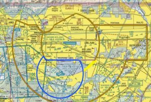
PROPOSED ONT CLASS C MODIFICATION